• Sailing is all about the Weather.

    Big into the exploration of Atlantic Hurricanes since Katrina came uninvited into his world, James (Jim) Gurley (JamesG161) has followed every Tropical Storm birthed in Atlantic, Gulf and Caribbean waters since. Being a boater, he knows that we often need more time to prepare than we get from the TV weather folk. Jim relies on the science of storm development to share early warning info with friends and fellow boaters.

    Early in 2018, Jim and John Shepard, (JSSailem) started to chat about the weather data available. John asked Jim to help forecast Pacific NW storms, and this morphed into discussions on weather forecasting.

    For John, sailing in the PNW is sometimes hit and miss. One day is ugly, then a string of beautiful days but no wind, followed by a series of blue-sky days and 12 knot breezes. Being ready for those great sailing days means you need to look to the Pacific Ocean and what is brewing. John has been into Pacific NW Weather since the 1970’s when his first PNW November storm hit bringing more than 40 days and 40 nights of continual rain.

    Together we want to share information, new APPs, safety, and thoughts about letting the weather help you. Identify some of the resources for sailors and help prepare you for your next sailboat outing.

    It is far better to go out on the water knowing what to expect in weather terms, than to be out on the water and see dark ominous clouds suddenly appear, unprepared.

Hurricane Zeta <--- TS Zeta <--- Invest 95L

Jan 19, 2010
12,362
Hobie 16 & Rhodes 22 Skeeter Charleston
Very cost prohibitive - and I believe someone looked into this a looooong time ago. :beer:
Well I have tried to research this topic several times and all I can find are discussions about either seeding it with silver iodine crystals or dropping a bomb into the storm. The crystal seeding has issues beyond efficacy. And the bomb idea does not drain energy but adds energy to the storm. And the bomb would have to be BIG. So... back to my original premise. What if we slowed or even stopped the up draft of warm air? I'm not talking about blowing out the hurricane. I'm thinking of knocking the engine driving the hurricane from a V8 to a V6.

Cost prohibitive? Maybe, I'll confess that I have not done a rigourous analysis but liquid nitrogen can be purchased for about $1/liter

reference:
(Price of Liquid Nitrogen - The Physics Factbook.)

So 100,000 liters = 26,417 gallons (I just pulled that number out of my arse but it seems big) would cost ~$100,000. Lets assume I'm clueless (I am) and the scale needed to be 5 times 100,000 liters and then double that for operational costs and you have a price tag of $1million.

Go crazy and assume my scale is not even close and scale by 1000x more and you are just now at a price tag of $1 billion. The estimated cost of Katrina was $125 Billion. I still think the insurance companies would be happy to foot the bill for any hurricane expected to make landfall on a major city even if all we accomplished was knocking a catagory 5 to a catagory 1. I can even imagine many countries pitching in to make one western-hemispher hurrican-busting fleet of planes (or drones) for this purpose. I just wouldn't want to be a ship under those clouds when all that moist air suddenly drops 50 degrees.

For the nerds... a typical hurricane generates 5.1E19 Joules/day or 2.13E18 J/hr

reference
!

The enthalpy of vaporization of liquid nitrogen is 199,200 J/Kg. The heat capacity of gaseous nitrogen is temperatue dependent but it is approx ~1100 J/Kg-C. The boiling point of liquid nitrogen is 77K (-196C). So a Kg of liquid nitrogen evaporating and then warming to room temperature (~25C) absorbs 442,300 Joules of heat energy.

If you assume the process of dumping liquid nitrogen into a hurricane would take an hour and you wanted to absorb half of the energy creation of the hurricane in that hour you would need 2,408 billion Kg. Okay that is a LOT but I don't think you will need that much. When a Kg of liquid N2 evaporates and warms, its volume expands to ~872 liters so you can expect a sudden high pressure zone to form where the eye of the hurricane once was. I think if we could knock even 10% of the energy out of the updraft we could affect the destructive power (no math here just a gut check). At worst I think we could nudge its trajectory.

I personally don't have the resources to test my theories..:biggrin: but if a government lab wants to give me a big grant.....:poop:
 
Jan 19, 2010
12,362
Hobie 16 & Rhodes 22 Skeeter Charleston
Simple answer is NO WAY JOSE!

I did the calculations a few years ago. Just take a small storm of just 100 miles in diameter.
The stored up Solar Energy from the Ocean that makes a storm is HUGE!!!
People even suggested just NUKE it with a few low yield bombs. Most nukes are only 3 miles in diameter.

Remember it took all year to HEAT up the Gulf and Caribbean. Stored Solar Energy.
Our sailboat's fuel, winds from Solar Energy.

No Sun, No Heat, No Fuel.

When Hurricane Hunters drop a buoy, it measures the relative humidity on that drop from 200mbar to surface.

This is dropsonde earlier today just off the Yucatan

View attachment 186657

The energy driving force is the area between the Green and Red lines and a low level drop one too. 700 mbars
Lot of real data info put into the NOAA models.
Note the pinch point at 916 mb , Zeta was not sucking up much HEAT.

End of Attenuation thoughts.
Jim...
Sorry I was typing while you posted that. I don't understand what that graph is showing.
 
Oct 22, 2014
20,989
CAL 35 Cruiser #21 moored EVERETT WA
I was looking for the "Simple Explanation" I saw a couple of years ago. It was focused on the cause / experienced results examination of the tropical storm formation.

What "Jim" said "Remember it took all year to HEAT up the Gulf and Caribbean. Stored Solar Energy." I have come to understand the heat in the ocean is the driver of storms. If you were wanting to disrupt the storm formation you would want to cool the ocean.

I found this site which may help to understand the formation.

The Science Behind The Formation Of Hurricanes

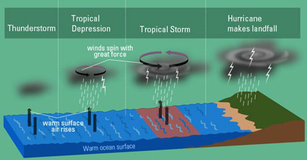
The first condition to form a hurricane is warm tropical water. This is why all hurricanes form near the equator, usually following a very predictable path. The next step in a hurricane's formation is the evaporation of warm tropical water into giant cumulonimbus clouds. Now the formation of a hurricane gets complicated. The cumulonimbus clouds begin to stack on each other forming giant columns of air. Heat energy is released from the cooling water vapor; the air at the top of the clouds columns warms up making the air pressure increase and causing winds to move outward away from the high pressure area. At this point thunderstorms form while the clouds begin to spin around the center point. Once wind speed reaches 39 miles per hour, the storm is classified as a tropical storm.


When wind speeds reach 74 mph, the storm is officially becomes a hurricane. Hurricanes stand around 50,000 feet high and around 125 miles across. The eye is around 5 to 30 miles across depending on the size of the storm. At this point the storm will continue to grow stronger as long as it has access to warm ocean water. The only good part is that it will cease to grow and start to deteriorate once it hits land. Of course this can also be catastrophic for mankind as the brute force of nature overwhelms the eastern seaboard.
 
  • Like
Likes: JamesG161
Feb 14, 2014
7,399
Hunter 430 Waveland, MS
At worst I think we could nudge its trajectory
Not even a budge.

The problem is that a Hurricane moves to find more energy quickly. [ normally 10 mph]
Do your calculations on the top 20 feet of Ocean water that has collect Solar Energy for months.

The Enthalpy of Water is Huge versus Liquid N2

Plus do you know how much Enthalpy was removed to Liquify Nitrogen?
Seeding clouds to rain more would work better, but that is nearly impossible too.

Look at John's explanation for more info on Hurricane formation.

What is the energy content of 100 miles in diameter and 20 feet of water depth on the path of a storm?

Scientist too...
Jim...

PS: I am not a scientist to a few on SBO, no names mentioned.:ass:
 
Jun 2, 2004
3,390
Hunter 23.5 Fort Walton Yacht Club, Florida
There was some group doing a study on this in the 90s. I was at Keesler then and had several friends who flew with the Hurricane Hunters whom we discussed this over many beers on one anothers boats. I initially only even noticed because they were flying a B-57 and I thought the only ones left were in a museum.

The theory works the problem is in the proportions. These storms are HUGE and dropping several or even hundreds of planefuls of liquid or solid nitrogen is kinda like lighting a match on the sun.

The resources it would take to make it effective would be better spent on preparation and mitigation along areas prone to storms.
 
  • Like
Likes: JamesG161
Jun 21, 2004
2,532
Beneteau 343 Slidell, LA
JIm,
appears that this one is going to be a CAT 2. Contradictory info; however, local NO weather forecasters predicting winds of 80mph later tonight. 5-7 foot surge on coast. Good thing is that is moving fast. Likely going to be problems with trees down and loss of power.
Hopefully the boats weather this OK. Be safe!:confused:

All I can say for now is...
The LOW pressure that Hurricane Zeta will follow, will determine the path.
Timing is every thing...
Jim...
 
Oct 22, 2014
20,989
CAL 35 Cruiser #21 moored EVERETT WA
You guys stay hunkered down as the storm is moving quickly towards the SE Coast of Louisiana. Agree with wind forecasts in and about 80mph. Alabama coast and possibly on to the Panhandle of Florida may see Tornado formations as the storm moves inland.

Looks right now like the Lake Charles area will not see its 3rd storm. Good news for them.

Storm could reach Cat2 status before making landfall this evening. A lot depends. The Texas Low. The time over water.

I believe there is another HH mission scheduled. Will check the reports.

Listen to your local weather and safety notices.
 
Oct 22, 2014
20,989
CAL 35 Cruiser #21 moored EVERETT WA
Latest from the HH flight showing winds on the East side of the eye in the 64-83 kt range.


Stop is about 100 miles out. Moving at a 15 plus kt pace.
 
Oct 22, 2014
20,989
CAL 35 Cruiser #21 moored EVERETT WA
I have been wondering. No responses to text messages. Guessing the Cell Tower may have been affected.
 
  • Like
Likes: JamesG161
Oct 22, 2014
20,989
CAL 35 Cruiser #21 moored EVERETT WA
Jim just texted that Zeta is over Big Easy and east of kloude1. Winds gusting. Power as been fine until just now. Flickered and out. Suspect there are trees knocking out the power.
 
  • Like
Likes: JamesG161