• Sailing is all about the Weather.

    Big into the exploration of Atlantic Hurricanes since Katrina came uninvited into his world, James (Jim) Gurley (JamesG161) has followed every Tropical Storm birthed in Atlantic, Gulf and Caribbean waters since. Being a boater, he knows that we often need more time to prepare than we get from the TV weather folk. Jim relies on the science of storm development to share early warning info with friends and fellow boaters.

    Early in 2018, Jim and John Shepard, (JSSailem) started to chat about the weather data available. John asked Jim to help forecast Pacific NW storms, and this morphed into discussions on weather forecasting.

    For John, sailing in the PNW is sometimes hit and miss. One day is ugly, then a string of beautiful days but no wind, followed by a series of blue-sky days and 12 knot breezes. Being ready for those great sailing days means you need to look to the Pacific Ocean and what is brewing. John has been into Pacific NW Weather since the 1970’s when his first PNW November storm hit bringing more than 40 days and 40 nights of continual rain.

    Together we want to share information, new APPs, safety, and thoughts about letting the weather help you. Identify some of the resources for sailors and help prepare you for your next sailboat outing.

    It is far better to go out on the water knowing what to expect in weather terms, than to be out on the water and see dark ominous clouds suddenly appear, unprepared.

Hurricane Zeta <--- TS Zeta <--- Invest 95L

Feb 14, 2014
7,399
Hunter 430 Waveland, MS
In a year of amazing activity, we have a new disturbance forming in the only spot left, with any significant stored Solar Heat,

Invest 95L finds it.

Talk about tracking at this time is ludicrous but here it is..
storm_95.gif


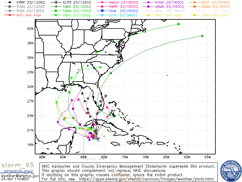
TABM/TABD good for 2 days or about a north course.

Where is BEEF aka HEAT?

ohc_aQG3_latest_natl-2.gif


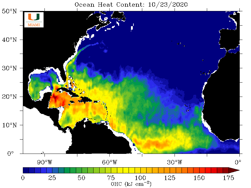
Duh... the only spot left for HEAT in the 2020 season.:facepalm:

But the good news, the Gulf is very cool now, so little intensifying to a major hit is unlikely.

Of course it will get a name of TS Zeta.

Jim...

PS: I think had one blind date, in college, with a girl named ZETA. Bad breath and a mustache.:laugh:
 
Nov 6, 2006
9,884
Hunter 34 Mandeville Louisiana
More like a Cajun slang term for a foolish person.. "Look at dat coo-youn feeding dat alligator!"
 
  • Like
Likes: BigEasy
Jan 19, 2010
12,362
Hobie 16 & Rhodes 22 Skeeter Charleston
Yes couyon = goofus

But the expression usually implies the person is doing something that will likely end in a visit to the ER
 
  • Like
Likes: jssailem
Feb 14, 2014
7,399
Hunter 430 Waveland, MS
Of course it will get a name of TS Zeta.
Over night a Hurricane Hunter made a pass through and did NOT find Tropical storm winds, but they did find the counter clockwise circulation.
recon_NOAA2-0228A-CYCLONE.png


The nearest buoy has 11 knot winds.
NDBC - Station 42056 Recent Data

At the time Tropical Storm Zeta is just stationary.

Key model are not lining up.

LOWs over TX will pull TS Zeta , there are no HIGHs to push it.

Late today more reliable information will be available.
Jim...

PS: Forecast for my area, in Coastal MS, has peak winds of 24 mph on Wednesday.
 
Feb 14, 2014
7,399
Hunter 430 Waveland, MS
All I can say for now is...

Yucatan HIT

Tracking Models are wrong until it passes into the Gulf of Mexico.

The LOW pressure that Hurricane Zeta will follow, will determine the path.
Timing is every thing...
Jim...
 
Oct 22, 2014
20,993
CAL 35 Cruiser #21 moored EVERETT WA
Damnit Jim.
That makes the whole Gulf Coast vulnerable. We need some way of steering these storms so they can become predictable. Then we can put them on Auto Pilot.
 
Feb 14, 2014
7,399
Hunter 430 Waveland, MS
Tracking models are close enough this morning.

@BigEasy and @kloudie1 will have the worst of it.

I am signing off for now to move my boat, since we are under Hurricane Watch now.

Hurricane Zeta will zip across the Gulf at 17.6 mph, very fast crossing.:clap:
Dammit Jim...
 
Oct 22, 2014
20,993
CAL 35 Cruiser #21 moored EVERETT WA
Well Storm watchers... Jim is off to shelter his boat.

Zeta is showing herself to be a pest. The third storm this year to impact the Yucatan Peninsula.
Testing the Gulf waters for her path towards our Gulf Coast, looks like the Low Pressure that formed in West Texas is going to be the steering agent as Zeta moves out into the Gulf this morning. Bad news is the southern area of the Gulf still has some warm waters and will provide some fuel to the storm as it moves in an initial NW direction. The upper level winds are somewhat moderate at this time. This will give some opportunity to Zeta to build vertically as she starts across the Gulf. The High Pressure over Florida is exerting some drag on Zeta. When coupled with the Texas Low it appears Zeta will move quickly across the Gulf (good News). If the Texas Low reaches Louisiana before Zeta comes ashore this will help to mitigate Zeta as a Hurricane. The cooler waters within a 100 miles of the US Gulf coast will also tend to attenuate Zeta. (more good news).

Currently Zeta is being called a Tropical Storm. The current tracks are trending showing Zeta's landfall somewhere from the SE Louisiana shore to the coast of Alabama. This of course places our leader Dammit Jim right in the center of Zeta's path. Jim and I talked about the possible storm surge With the current track and speed of the storm crossing the gulf storm surge may be on the weaker side.

Stay safe out there. Listen to your local advisories. While the current structure in the Gulf and the winds aloft sound positive, we all know storms can have a mind of their own. The next 18 hours will tell us how Zeta will form to be what she wants to be.
 
  • Like
Likes: JamesG161
Jan 19, 2010
12,362
Hobie 16 & Rhodes 22 Skeeter Charleston
You all know a lot more about this than I do but I've had this nagging question for some time now.... and I'm guessing that if it were actually a good idea, we would have already done it but... why can't we attenuate the power of a hurricane?

My understanding (and I'm sure there are some holes) is this... the warm air in the eye rises....
1603811191507.png


and as the air rises it cools and spills over the sides... the coriolis effect gets it spinning... like this...

1603811467191.png


So if the engine that runs a hurricane is rising warm air, why can't we just cool those air columns down? I'm thinking a fleet of a hundred or so C140's packed full of liquid nitrogen dewers with altitude detonators should do the trick.
1603811771397.png


Drop the dewars in the rising air columns and have them go off about mid column. Or engineer something like this...

1603811836750.png


It might cost a billion dollars per storm but I'm sure the insurance companies would come out ahead if they funded it. Okay you strom experts.... tear me a new one... ;)
 
  • Wow
Likes: JamesG161
Feb 14, 2014
7,399
Hunter 430 Waveland, MS
Ok my total crew[landlubbers too] tied us up in record time. Took about 1.5 hours as they laughed about how easy it was for the THIRD time this year.:banghead:

I even let my neighbors power boat [40 footer] have 3 extra hurricane tie up lines.

But we are ready.

Image 10-27-20 at 11.28 AM.jpg

Looking like 9pm Wednesday nite for the Eye to pass over @kloudie1 and @BigEasy.

It is moving so fast that when the Eye passes, and the winds change direction, little storm surge is expected.

I do hope this Ends the 2020 season.:ass:
Dammit Jim...
 
Feb 14, 2014
7,399
Hunter 430 Waveland, MS
why can't we attenuate the power of a hurricane?
Simple answer is NO WAY JOSE!

I did the calculations a few years ago. Just take a small storm of just 100 miles in diameter.
The stored up Solar Energy from the Ocean that makes a storm is HUGE!!!
People even suggested just NUKE it with a few low yield bombs. Most nukes are only 3 miles in diameter.

Remember it took all year to HEAT up the Gulf and Caribbean. Stored Solar Energy.
Our sailboat's fuel, winds from Solar Energy.

No Sun, No Heat, No Fuel.

When Hurricane Hunters drop a buoy, it measures the relative humidity on that drop from 200mbar to surface.

This is dropsonde earlier today just off the Yucatan

recon_NOAA2-1228A-ZETA_dropsonde4_20201027-1034.png


The energy driving force is the area between the Green and Red lines and a low level drop one too. 700 mbars
Lot of real data info put into the NOAA models.
Note the pinch point at 916 mb , Zeta was not sucking up much HEAT.

End of Attenuation thoughts.
Jim...