Getting a stand alone Bluetooth GPS receiver is cheaper that the cell model IPad, more accurate and allows multiple devices to connect to it ( dependent on which model). It also decreases the battery draw on the IPadMake sure it has an internal GPS. At least in the Apple line, this means getting a wifi and cellular model. The GPS chip is on the cell phone chip. The WiFi only models get location data from the wifi network. You do not need a cellular data plan, just have the capability.
Recommendation on Tablet to use for Navionics App?
- Thread starter Rikejr
- Start date
I started with an old LG Phone running Navtronics, it worked well but the screen was too small. I then found a used 2018 Verizon Galaxy Tab A for $50 and a Unicorn Beatle Case with some creative mouting has been perfect for us.
Some action shots are in my thread:
Our 2003 C310! | Sailboat Owners Forums
Some action shots are in my thread:
Our 2003 C310! | Sailboat Owners Forums
I don't know if there is a way to check, but I have heard that larger tablets cannot charge as fast as they discharge the battery when running Navionics and can lead to a temporarily unusable device. Once again it's just something I have heard so it is not admissible as evidence.
My mini ipad 7" has never had this problem, over heating in the waterproof case is an issue.
My mini ipad 7" has never had this problem, over heating in the waterproof case is an issue.
My tablet does that if plugged into an incompatible charger. I added higher output USB outlets at the chart table and they work well.I don't know if there is a way to check, but I have heard that larger tablets cannot charge as fast as they discharge the battery when running Navionics and can lead to a temporarily unusable device. Once again it's just something I have heard so it is not admissible as evidence.
My mini ipad 7" has never had this problem, over heating in the waterproof case is an issue.
I recommend a Samsung galaxy tab active. IP68 rated (yes even when charging, ports are waterproof too), can handle higher temps than standard tablets, battery is swappable so you can have a backup.
I run navionics on mine, will sync happily with the one on your iPhone (one account works on all devices you own regardless of OS). AIS overlay on the charts from any compatible wifi enabled unit.
Get a ram mount you can click it in in 2 seconds and you have waterproof charging, remove from mount and store below when at the dock. Electrics on the boat go down you can get about 12-16 hours of navigation on a full battery (double that if you keep a charged battery as a spare). If it’s charging in the sun and getting too hot it will stop charging and run off the battery to cool down (an iPad will shut down).
Battery ages (as they all do) and you can buy just the battery. Drop it underwater it will be fine. Screen works when wet or with gloves. Charge it in the pouring rain no problem. Try that with an iPad. Oh it costs less than an iPad too.
The tab active is designed specifically for outdoor use; other tablets are fragile, prone to overheating in the sun, not even water resistant, and must be treated with great care. Seems an easy choice to me.
bonus-Sd card expandable memory. Load 3 weeks of movies on the thing if you want.
Last edited:
I’ve been using an older iPad with a Dual external gps for a back up at my chart table for years and it’s been pretty reliable. XGPS150A - Universal GPS Receiver — Dual GPS Solutions
I have a Garmin chartplotter at the helm which is my primary mode of navigation. It has an internal WiFi as does my Vesper AIS. I’m not sure if the iPad can’t or could join the WiFi and obtain a gps location from either devices. The Navionic app and the Garmin show AIS data so it must be picking up that data from the Vesper.
I have a Garmin chartplotter at the helm which is my primary mode of navigation. It has an internal WiFi as does my Vesper AIS. I’m not sure if the iPad can’t or could join the WiFi and obtain a gps location from either devices. The Navionic app and the Garmin show AIS data so it must be picking up that data from the Vesper.
jssailem
SBO Weather and Forecasting Forum Jim & John
- Oct 22, 2014
- 24,454
Your Vesper AIS, if the XB8000, will let your iPad running a compatible app like iNavX join using the WiFi gateway. You will receive all data that is shared through the AIS. The Vesper will share GPS location provided by the Vesper antenna. If you have a NMEA 2000 connection to Vesper that data will be available to the iPad or other devices you connect to the Vesper WiFi. You can connect up-to 5 devices.I’m not sure if the iPad can’t or could join the WiFi and obtain a gps location from either devices.
Talk about back up.
I think my Ipad 2 with an external GPS antenna might finally be retired(still works fine). It started as back up to an old hard wired CP(still works fine). But it became the better planning CP with the larger screen.
Then the iPad became the more depended upon CP. An iPhone with another nav app became back-up to the iPad, the Garmin became back-up, back-up.
I retired my last iPhone (6, something- still works fine) and have gone to an 11. I didn't want the extra size of the 12 (or the cost) as it lives in my pocket.
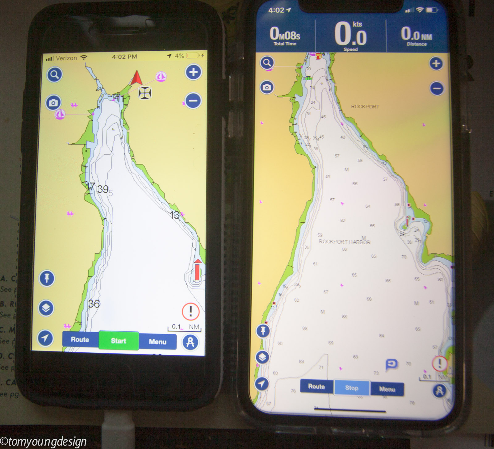
The new iphone is essentially the same pocket size (a bit bigger), but the screen is much bigger. Here's my harbor on both:
I've been trying to settle on a small CP to replace the ancient Garmin on the mount that swings in an out of the companionway (still works even after the last, big, GPS whatever it was,...). I like that it only uses 4W as it runs 24/7. It's a great anchor minder.
But I notice, the screen on the old Garmin is 5" dia. My iPhone is over 6" dia.
And my wife has an iPhone 12 which is substantially larger in screen size (and a better zoom lens for me") ). We'll put Navionics on that as well.
). We'll put Navionics on that as well.
At this point, I'm not sure what I'll do with CP's.
Then the iPad became the more depended upon CP. An iPhone with another nav app became back-up to the iPad, the Garmin became back-up, back-up.
I retired my last iPhone (6, something- still works fine) and have gone to an 11. I didn't want the extra size of the 12 (or the cost) as it lives in my pocket.
The new iphone is essentially the same pocket size (a bit bigger), but the screen is much bigger. Here's my harbor on both:
I've been trying to settle on a small CP to replace the ancient Garmin on the mount that swings in an out of the companionway (still works even after the last, big, GPS whatever it was,...). I like that it only uses 4W as it runs 24/7. It's a great anchor minder.
But I notice, the screen on the old Garmin is 5" dia. My iPhone is over 6" dia.
And my wife has an iPhone 12 which is substantially larger in screen size (and a better zoom lens for me
). We'll put Navionics on that as well.At this point, I'm not sure what I'll do with CP's.
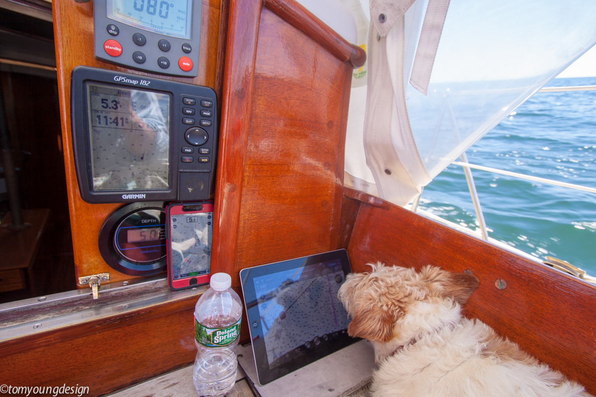
I thought he was route planningLooks like the pooch is enjoying the reflective selfi
I second this. I have the active2, love that it's waterproof and doesn't overheat in the sun. The one downside of just about all phones/tablets is that they have glossy screens. One could add a matte screen protector, but would be better if phones & tablet came out of the factory with a matte screen option.I recommend a Samsung galaxy tab active. IP68 rated (yes even when charging, ports are waterproof too), can handle higher temps than standard tablets, battery is swappable so you can have a backup.
I run navionics on mine, will sync happily with the one on your iPhone (one account works on all devices you own regardless of OS). AIS overlay on the charts from any compatible wifi enabled unit.
Get a ram mount you can click it in in 2 seconds and you have waterproof charging, remove from mount and store below when at the dock. Electrics on the boat go down you can get about 12-16 hours of navigation on a full battery (double that if you keep a charged battery as a spare). If it’s charging in the sun and getting too hot it will stop charging and run off the battery to cool down (an iPad will shut down).
Where on the boat have you mounted your ram mount?
It is for me. Increasing redundancy and versatility in the new tools. I haven't piloted on paper in over 10 years so I tossed all my outdated charts.Progress or not? Only you can decide. Looks like the pooch is enjoying the reflective selfie.
I do not see a paper chart in the mix.
I'm glad I didn't blast any holes in the boat for gizmos. Their use is evolving so quickly. I'm waiting (were close) to when AIS is more useful on my coast.
One thing I find most useful today is the CP in my pocket. I'm rarely behind the wheel so pods would be little use to me. To have a reliable CP that can call up weather, local info and keep track of where I am has made that location (pocket), permanent.
It's a good time to be piloting.
Excuse my ignorance on this subject. I have no knowledge or experience with marine GPS Guidance. I am starting to do some coastal cruising my area doesn’t have strong cell service. Would a tablet with cell capability and navionics app. Work as my navigation system?
That setup will work fine, in the sense that it will show your position on the Navionics chart. You don’t need active cell service or even a subscription for the GPS to work - you just need the cell hardware in the device because the GPS radio is packaged with that.Excuse my ignorance on this subject. I have no knowledge or experience with marine GPS Guidance. I am starting to do some coastal cruising my area doesn’t have strong cell service. Would a tablet with cell capability and navionics app. Work as my navigation system?
Whether a tablet is an adequate navigation system as compared to a traditional purpose-built GPS is a matter of a whole further discussion.
jssailem
SBO Weather and Forecasting Forum Jim & John
- Oct 22, 2014
- 24,454
Welcome to the SBO Forum @BaC and congrats on your starting new adventures.starting to do some coastal cruising my area doesn’t have strong cell service.
My thinking about GPS and navigation or "Coastal Cruising" is not about the beautiful weather days, but the nasty, wind blowing, huge waves, rain, fog, dark miserable weather that can suddenly appear and test your sailing skills. It is times like this that the best of the digital equipment can suddenly fail. That is not when you want to bet your life on a tool designed to work in the safe secure environment of your home.
Assuming that economics is driving this question, I would lean towards one of the Garmin hand held GPS gadgets. Easy to have in the cockpit. Designed for use in wet conditions. Relatively inexpensive. And a good chart of your area. You can get charts free from the NOAA site. Print as many off as you desire.
At some point you may want to extend your adventures. This may cause you to look for a Chart Plotter and all that installing one and the battery needs included.
What ever path you take study up on navigation, dead reckoning, and weather.
Good luck
The two charting apps I use work off line. You don’t need a GPS. I prefer a stand alone GPS receiver that connects with BT. It allows for cheaper/non-cell service IPADs and lowers the potential of the iPad overheating by not using more battery.
If you are talking about Android tablets (not iPad) then the discussion about cell capable is different. iPads are oddball in that the GPS receiver is part of the same radio component as the cellular radio, not true with most Android devices. My Lenovo without cell capability has a very good GPS receiver.Excuse my ignorance on this subject. I have no knowledge or experience with marine GPS Guidance. I am starting to do some coastal cruising my area doesn’t have strong cell service. Would a tablet with cell capability and navionics app. Work as my navigation system?
When it comes to discussing dedicated purpose built GPS handheld devices vs. phones or tablets, I'd put my life in a Samsung before a Garmin. I've had handheld Garmin devices fail but I have mistreated several Samsung's that have never let me down (until the battery finally dies). They have much better screen resolution and work in sunlight - I'm typing this in my cockpit in full sunlight on my Galaxy S10. Plus the charts automatically update when you connect to a network. They are waterproof and, with a good case, very rugged.
A dedicated plotter at the helm is still a good idea as well as having paper charts for backup but practice coastal navigation with the paper charts or they won't be much use when you pull them out in anger.
Debatable, without the energy calculation and heat diss specs of the hardware involved. I would argue that overall energy used on the boat is the same or greater if using external Bluetooth devices + mob devices, vs internal GPS. The difference is negligible and not worthy of concern. I prefer having an all in one package such as phone or tablet with internal GPS; no finicky pairing involved and fewer charging cord/battery concerns.lowers the potential of the iPad overheating by not using more battery.