• Sailing is all about the Weather.

    Big into the exploration of Atlantic Hurricanes since Katrina came uninvited into his world, James (Jim) Gurley (JamesG161) has followed every Tropical Storm birthed in Atlantic, Gulf and Caribbean waters since. Being a boater, he knows that we often need more time to prepare than we get from the TV weather folk. Jim relies on the science of storm development to share early warning info with friends and fellow boaters.

    Early in 2018, Jim and John Shepard, (JSSailem) started to chat about the weather data available. John asked Jim to help forecast Pacific NW storms, and this morphed into discussions on weather forecasting.

    For John, sailing in the PNW is sometimes hit and miss. One day is ugly, then a string of beautiful days but no wind, followed by a series of blue-sky days and 12 knot breezes. Being ready for those great sailing days means you need to look to the Pacific Ocean and what is brewing. John has been into Pacific NW Weather since the 1970’s when his first PNW November storm hit bringing more than 40 days and 40 nights of continual rain.

    Together we want to share information, new APPs, safety, and thoughts about letting the weather help you. Identify some of the resources for sailors and help prepare you for your next sailboat outing.

    It is far better to go out on the water knowing what to expect in weather terms, than to be out on the water and see dark ominous clouds suddenly appear, unprepared.

Hurricane Isaias <--- TS Isaias <--- PTC 9 <--- Invest 92L

Feb 14, 2014
7,399
Hunter 430 Waveland, MS
We noted this tropical wave when it was 20 days away. World wide weather information continues to improve.:biggrin:

Of all the Northern Atlantic storms in 2020, this is the one to watch closely for USA impact.

storm_92.gif


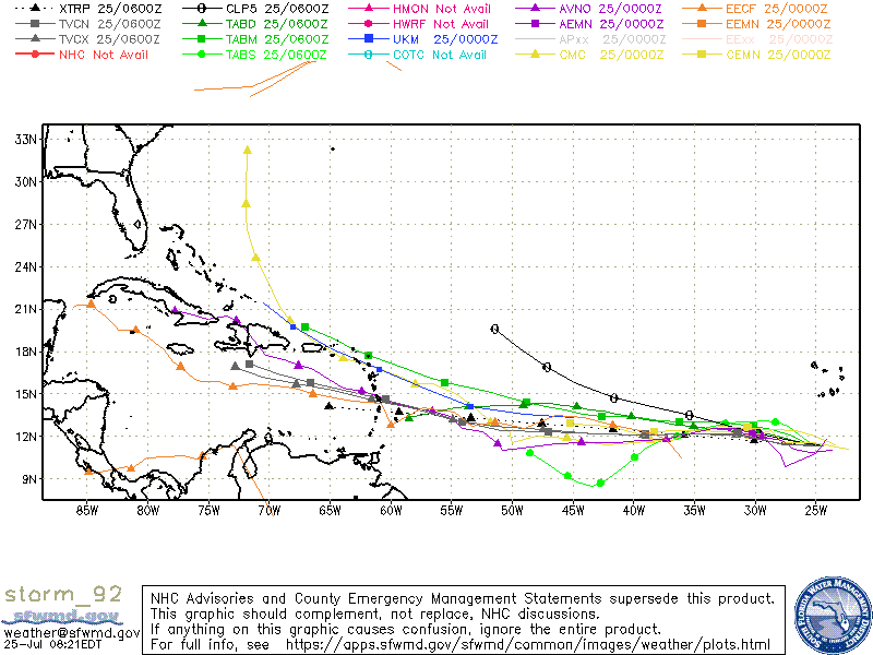
I like TABM for the first 4 day tracking.

The good news...

TS Gonzalo removed a lot of Atlantic Heat from the birthing area and our oceans have less overall Heat this year.;)

cdas-sflux_ssta7diff_eatl_1.png

Jim...

PS: Sahara Dust is working well to dampen this storm.
 
Last edited:
Feb 14, 2014
7,399
Hunter 430 Waveland, MS
Potential Tropical Cyclone #9 is gaining some strength as it approaches the Antilles.

The principle models again, disagree.

When they disagree, I fall back on the movements of Pressure fronts and their timings.

HIGH pressures generally move ESE at about 10 miles/hour, this time of the year.

HIGHs push LOWs;)

PTC 9.jpeg


The
HIGH over CO now is the key timing one.
Jim...
 
Last edited:
  • Helpful
Likes: Will Gilmore
Nov 18, 2010
2,441
Catalina 310 Hingham, MA
In Maho Bay on St. John, USVI. Getting the outer edge rain bands now. The Euro was right again. At least for track. They have been good on this intensity as well.

Currently seeing 4 knots gusting to 25. Some rain but not true downpour yet.

Fair winds,

Jesse
 
  • Like
Likes: JamesG161
Feb 14, 2014
7,399
Hunter 430 Waveland, MS
Euro model [ECMWF] seems best for open waters and GFS [NOAA] takes over near mainland USA coast.

Both models are now converging and showing the Islands as the disrupter.

The Dry Sahara Dust is denying a lot of Convection moisture [surface to jet stream up-flow]

The HIGH over CO yesterday is stalling and shows a stationary front.

Friday 31st will be best for a good direction.
Jim...
 
Feb 14, 2014
7,399
Hunter 430 Waveland, MS
Tropical Storm Isaias [ E sigh azz ] barely made that status overnight, as the CCW motion became apparent.

The Hurricane Hunters are trying to find the center of the storm now.
Once they find it, the tracking models will be more reliable.

As normal, the highest winds are found on the Eastern Half of the circulation.

It appears to be East Coast Skimmer, which will be mainly rain and storm surge.
recon_AF309-0409A-ISAIAS.png


The crossing flight paths are where the Hunters are finding the center. Barometric Pressure 1005 millibars.
Jim...

PS: Those wind barbs are at flight level, not surface which are estimated at barely 40 knots.
 
Last edited:
  • Helpful
Likes: Will Gilmore
Jan 1, 2006
7,039
Slickcraft 26 Sailfish
Yeah the media, i.e. Weather Channel loves a storm. But I never dismiss these things. Remember my namesake Andrew? It was a disorganized, nare do well storm. But it devastated Homestead. So I'll stand on guard.
 
Feb 14, 2014
7,399
Hunter 430 Waveland, MS
We are posting this as of 9am Eastern and our last analysis, since the news cycle will take over as @Captain Larry-DH just posted a link in #13 above.
____
Good News part...
We are not seeing Hurricane Isaias strengthening and is barely keeping its Hurricane status. Most of the High Winds should remain offshore.
HIsaias.jpeg


The main reason for weakening...
I showed the upper air wind directions on this EMCWF tracking model above.
HIGHs are CW and LOWs are CCW.

Dry Sahara Dust winds are reducing the surface evaporation or heat engine fuel.
The storm is being "sucked in" by the almost stationary LOW over New Jersey now.
______
Bad News part...
Storms Surge and Coastal flooding. Not much fun sailing along the South East Coast this weekend.
______

Dammit Jim...

PS: The Gulf was protected by the HIGH, so we are going sailing.:biggrin:
 
  • Helpful
Likes: Will Gilmore

jviss

.
Feb 5, 2004
6,745
Tartan 3800 20 Westport, MA
Thanks. Any prognosis for New England Coast, like where I will be for the next week - Rhode Island Sound, Buzzards Bay?
 
May 17, 2004
5,025
Beneteau Oceanis 37 Havre de Grace
jviss and I will both be watching the track closely it seems. I’m planning on a few day trip on the northern Chesapeake later this week. Plan was to leave Wednesday. Hopefully Isaias passes through by then.
 
  • Like
Likes: jssailem
Jun 14, 2010
2,081
Robertson & Caine 2017 Leopard 40 CT
jviss and I will both be watching the track closely it seems. I’m planning on a few day trip on the northern Chesapeake later this week. Plan was to leave Wednesday. Hopefully Isaias passes through by then.
It will pass before Wednesday.