• Sailing is all about the Weather.

    Big into the exploration of Atlantic Hurricanes since Katrina came uninvited into his world, James (Jim) Gurley (JamesG161) has followed every Tropical Storm birthed in Atlantic, Gulf and Caribbean waters since. Being a boater, he knows that we often need more time to prepare than we get from the TV weather folk. Jim relies on the science of storm development to share early warning info with friends and fellow boaters.

    Early in 2018, Jim and John Shepard, (JSSailem) started to chat about the weather data available. John asked Jim to help forecast Pacific NW storms, and this morphed into discussions on weather forecasting.

    For John, sailing in the PNW is sometimes hit and miss. One day is ugly, then a string of beautiful days but no wind, followed by a series of blue-sky days and 12 knot breezes. Being ready for those great sailing days means you need to look to the Pacific Ocean and what is brewing. John has been into Pacific NW Weather since the 1970’s when his first PNW November storm hit bringing more than 40 days and 40 nights of continual rain.

    Together we want to share information, new APPs, safety, and thoughts about letting the weather help you. Identify some of the resources for sailors and help prepare you for your next sailboat outing.

    It is far better to go out on the water knowing what to expect in weather terms, than to be out on the water and see dark ominous clouds suddenly appear, unprepared.

Humberto <--PTC 9 <--Invest 95L

Oct 22, 2014
20,992
CAL 35 Cruiser #21 moored EVERETT WA
Looking at Humberto this graphic may help understand the wisdom being shared in this Sailors Text
Winds around a Low.jpg


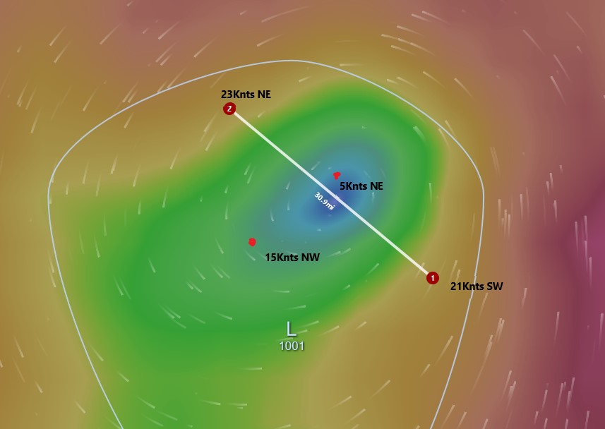
Traveling from point 2 to point 1 you leave a wind field of 23knots See the barometer drop as you cross the eye it becomes calm then start into another wind field traveling in the opposite direction and with some increasing force moving from Yellow to Red is sailing into increasing wind strength 30-40 Knots. The storm is moving in NE direction The place to be in this storm is to the SW. Where the breezes are 15 from the NW. The Green Zone.
 
  • Like
Likes: JamesG161
Oct 22, 2014
20,992
CAL 35 Cruiser #21 moored EVERETT WA
Reading again the post, I expanded the image and you can see on this image 2 that if you move from the lower right to the upper left in the storm (moving in a NW direction across the storm) you go from a red zone 30-40 knots SW into a calm (Storm Eye) then back into the wind and a Red Zone 30-40 knots out of the north.
Winds around a Low2.jpg


Another way of looking at this is to examine Dorian now out in the Atlantic. There is large 30-40 knot windfield (the area in Red) between the center of the Low and the following (pushing ) High Pressure shepherding Dorian across the Northern Atlantic.
Dorian out in the Atlantic.JPG
 
  • Like
Likes: JamesG161
May 24, 2004
7,129
CC 30 South Florida
Wow, the real track of this disturbance blew out the early track models. Meteorologists agree than when a disturbance lacks organization and a defined center the models do not perform as well. I was one that thought for sure that disturbance would enter the Gulf after crossing Florida based on the time of the year and previous systems observations, but I was wrong but not surprised. That is how weather is.
 
Oct 22, 2014
20,992
CAL 35 Cruiser #21 moored EVERETT WA
Yes Benny weather will change.
As Jim often reminds me you need to look beyond the surface reports and look at the big picture.
 
Jan 1, 2006
7,039
Slickcraft 26 Sailfish
Another way of looking at this is to examine Dorian now out in the Atlantic. There is large 30-40 knot windfield (the area in Red) between the center of the Low and the following (pushing ) High Pressure shepherding Dorian across the Northern Atlantic.
View attachment 169707
Are you saying in the Dorian example that the pushing high is compressing the isobars thereby increasing the wind. Or that too much of an oversimplification?
 
  • Like
Likes: JamesG161
Feb 14, 2014
7,399
Hunter 430 Waveland, MS
1864 manual for Naval Cadets
Cool find!:plus:

Their example of 29" Hg = 989 milliBars is a nice semi-tropical storm

and 29.5 " Hg = 998 milleBars. rise o_O

It not so much a Fair Weather Barometer Rise.

IMHO a Fair Weather rise would bet 1000mb to 1012 mb...

Jim...

PS: Was that the Confederate Naval Cadets?:pimp:
 
May 24, 2004
7,129
CC 30 South Florida
Believe me here in Florida we are very aware of the weather and the reliability of forecasted tracks and intensity, I remember in 2005 there was a train of 3 named storms that caused me to make decisions about securing the boat during a two week period. For two of them chose to stay at the dock but for one moved the boat to a Hurricane hole. I would say over the years I may have prepared a boat for a named storm at least 25 times and knock on wood have not lost one yet. Like I say prepare the boat but foremost make sure the insurance premiums are up to date.
 
Feb 14, 2014
7,399
Hunter 430 Waveland, MS
Or that too much of an oversimplification?
Not at all, in John's Dorian example.
That HIGH pushes, and Bends Dorian's LOW.

Thus the winds must accelerate to continue to CCW circulate.
Jim...
 
Feb 14, 2014
7,399
Hunter 430 Waveland, MS
Humberto [ umm Bear Toe] is now a Hurricane and is NOT following old Dorian.

We are getting Pacific HIGHs pulsing Eastward.

So Humberto is following behind another HIGH.
Jim...
 
Aug 22, 2017
1,609
Hunter 26.5 West Palm Beach
The latest forecast has Humberto going Major just before reaching Bermuda.