high water?

May 25, 2012
4,335
john alden caravelle 42 sturgeon bay, wis
new november readings. lakes michigan/huron are 16" higher today than they were one year ago. still predicting a wetter than average winter.
next year could be 24" + higher than last.
 
Jan 11, 2014
11,423
Sabre 362 113 Fair Haven, NY
new november readings. lakes michigan/huron are 16" higher today than they were one year ago. still predicting a wetter than average winter.
next year could be 24" + higher than last.
It's not looking good for next spring and summer. Spoke with my marina owner this afternoon. He's already planning on how to deal with the flood waters.
 
  • Like
Likes: jon hansen
Aug 2, 2010
502
J-Boat J/88 Cobourg
Lake Ontario info from the IJC website.

This report adds credibility to my question about manipulation of water levels causing at least some of the issue in Lake Ontario. I don't wish to imply that keeping the levels constant and appropriate for all would be easy but the need to deviate from the agreement implies previous behaviours that contributed to the problem over the last few years.
 
  • Like
Likes: Will Gilmore
Jan 11, 2014
11,423
Sabre 362 113 Fair Haven, NY
This report adds credibility to my question about manipulation of water levels causing at least some of the issue in Lake Ontario. I don't wish to imply that keeping the levels constant and appropriate for all would be easy but the need to deviate from the agreement implies previous behaviours that contributed to the problem over the last few years.
No, it does not. The need to deviate simply means that some conditions differ from the models used to guide their decisions about outflow. The most salient conditions that have occurred in the last few years are abnormally high precipitation rates in the Great Lakes Basin which cause abnormally high water levels in the upper lakes. All that water flows uncontrolled through Lake Ontario.

Around 2013 there was abnormally low levels of precipitation in Great Lakes Basin and as a result the upper lakes were lower than usual resulting in lower water levels and less inflow into Lake Ontario. If and when those conditions occur again, the IJC will need to restrict the outflow.
 
Sep 22, 2018
1,869
Hunter 216 Kingston
This report adds credibility to my question about manipulation of water levels causing at least some of the issue in Lake Ontario. I don't wish to imply that keeping the levels constant and appropriate for all would be easy but the need to deviate from the agreement implies previous behaviours that contributed to the problem over the last few years.
It is my understanding the “plan” has defined limits. It also has a vehicle to have a review process based on what is happening and if deemed appropriate the limits can be overridden for a set period of time.

The ability to “control” the Lake Ontario outflow and to some small degree it’s level lies with the “tap” at the dam. Because Lake Ontario is downstream of all the other Great Lakes the tap has no effect on their levels. If there is a lot of precipitation in the entire basin the lake levels are going to be high because it is beyond human control, same is true for low precipitation - lake levels will be low.
My 2 cents for what it’s worth.
 
  • Like
Likes: Will Gilmore
May 25, 2012
4,335
john alden caravelle 42 sturgeon bay, wis
huge system dumping lots of rain on the lake michigan/huron water shed today. the pattern continues.
 
Feb 14, 2014
7,422
Hunter 430 Waveland, MS
  • Like
Likes: jon hansen

DougM

.
Jul 24, 2005
2,242
Beneteau 323 Manistee, MI
High water and wind took out the pierhead light an Manitowac Wisconsin about a week
ago. Screen shot of an Mlive.com article
F501A013-4551-4AD1-90CF-3A5347E47BAD.png
 
  • Like
Likes: Will Gilmore
Aug 2, 2010
502
J-Boat J/88 Cobourg
Now that I have been looking for it I have seen several people and groups blaming the 2014 plan for at least some of the issues. One complaint centered around the make-up of the Commission which they claimed needed a better balance between stakeholders above and below the dam at the eastern end.
Again, I don't wish to blame anyone or claim to know what all the levers are but I think this needs to be an element of the discussion. I vividly remember when they changed the system for the Trent Severn Waterway with new people and new systems/rules. There was chaos with some lakes too low and some too high but clearly not enough management when unusual things happened with the water flow.
Dan
 
Jan 11, 2014
11,423
Sabre 362 113 Fair Haven, NY
The change in the 2014 plan involved raising and lowering the lake/river level about 4-6" at different times of the year. Primarily to flood some wet lands to help restore them. The 2017 and 2019 floods were primarily due to excessive rainfall throughout the Great Lakes Basin and the Ottawa River basin.

If the old plan was in place the lake would have flooded, perhaps it might have been a few inches lower, but it still would have flooded. With the upper lakes still above average levels and Lake Ontario still a foot or more above average another flood in 2020 seems likely.
 
Sep 22, 2018
1,869
Hunter 216 Kingston
Well they have opened the tap like they said. I’m hoping the freeze up holds off so they can keep it wide open for awhile. Up to Mother Nature to decide that I guess! ;)

A3847F3B-0F7A-4DDC-88C8-47A76823DA19.jpeg
 
  • Like
Likes: dlochner

TomY

Alden Forum Moderator
Jun 22, 2004
2,759
Alden 38' Challenger yawl Rockport Harbor
I've learned a lot about the Great Lakes from this thread. Our local Island Institute has been working with islands in the Great Lakes to form a similar coalition of our islands off the coast of Maine. There was an article in the Working Waterfront this month centered around a meeting on Mackinac Island.


It was interesting to see the similarities to Maine islands but also the differences. As this thread has shown, there's little similarity to the GL rising waters as our islands and coastline deal with sea level rise. Yet both are related to climate change.

Another island concern that is unique to the GL which I hadn't thought about are 'ice bridges'. That was a new one on me.

Islands like Mackinac usually get frozen in at some point, and that ends ferry service. Then the only island links are 'ice bridges' for snowmobiles or trucks from supplies and mainland connections. We deal with winter weather ferry delays and closures regularly as big seas shut service down to a day or so. An ice bridge relies on predictable cold which is becoming less predictable.

It's been over 50 years since our Penobscot Bay last froze solid enough to drive vehicles on the ice to the islands out in the bay.

I enjoyed reading this aticle and see the similarities in housing, employment, tourism. We share all this stuff with our island connections.

Do you guys have special island cars? I'm proud to say, at least one of ours ended up and 'island car' Def. Island car or truck; no longer inspectable,...

Island truck.jpg


Island truck gassing up.jpg


Island car #42.jpg
 
  • Like
Likes: Will Gilmore
May 25, 2012
4,335
john alden caravelle 42 sturgeon bay, wis
stats are in: michigan/huron for december were 16.5 over last dec. more above average rain predicted
 
Aug 27, 2012
92
Hunter 1990 Hunter 35.5 Toronto
That's the myth people want to believe because they want to blame someone for the damage to their property caused by record rainfalls throughout the Great Lakes Basin.

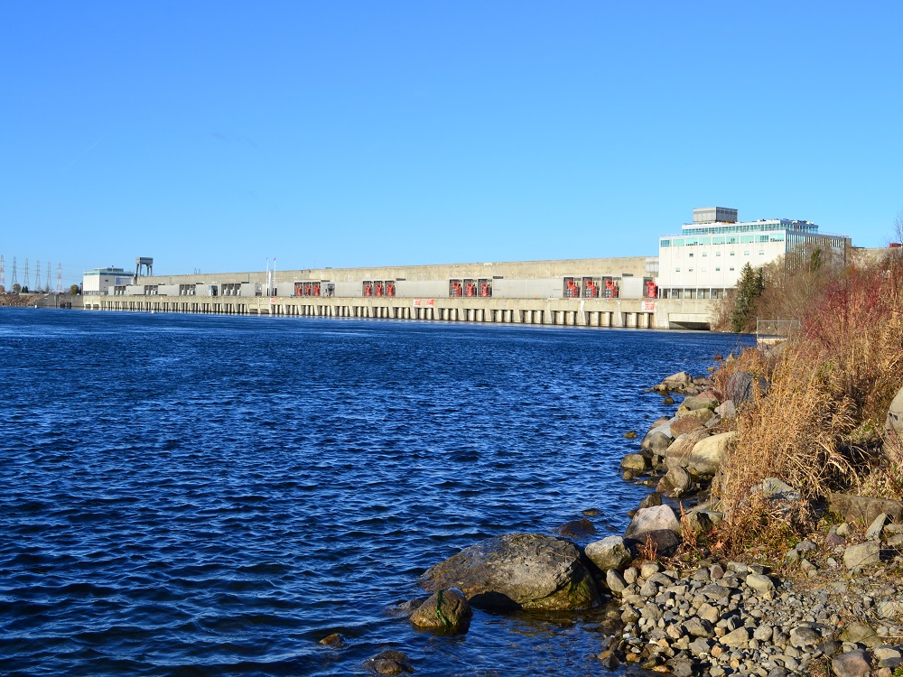
People also want to believe the Moses-Saunders Dam can just be opened and all the water will immediately drain away. Of course if the dam suddenly disappeared and the water left via the St Lawrence, Montreal would be washed away in the process. Lowering the water 1 inch on Ontario raises the water 11 inches in Montreal. Dropping the water 1 foot on Lake Erie would raise the water level on Ontario by about 16 inches.

Between Duluth and the Moses-Saunders dam on the St Lawrence there is only one dam, at Sault St Marie, the outlet for Lake Superior. And all that water flows right through my marina. :(

April 8 this past spring the lake was 246’ at that point the spring melt was happening on the Ottawa River in 5-6 weeks with them slowing the out flow at the dam to protect Montreal the water went to over 249’
At that time they were able to open the dam and the out flow was maxed out for a couple of months at 10,400
They dropped the level back to 246’
Since then they have cut the out flows way back to 8,500+- to reduce the current for shipping
This period was the time when they could of lowered the water to 244.5 and it would of set us up for a good spring. Instead shipping got preference over the entire lake and we are now really in danger of even higher levels this coming spring
 
Aug 27, 2012
92
Hunter 1990 Hunter 35.5 Toronto
April 8 this past spring the lake was 246’ at that point the spring melt was happening on the Ottawa River in 5-6 weeks with them slowing the out flow at the dam to protect Montreal the water went to over 249’
At that time they were able to open the dam and the out flow was maxed out for a couple of months at 10,400
They dropped the level back to 246’
Since then they have cut the out flows way back to 8,500+- to reduce the current for shipping
This period was the time when they could of lowered the water to 244.5 and it would of set us up for a good spring. Instead shipping got preference over the entire lake and we are now really in danger of even higher levels this coming spring