Why We Still Carry Paper....

Status
Not open for further replies.
Feb 6, 1998
11,760
Canadian Sailcraft 36T Casco Bay, ME
Over the years, been using chart plotters since 1997, I have come across many errors and omitted pieces of data from the NOAA cartography. This is why I still carry paper and do my best to mix that and my plotters information with "local knowledge". When cruising my home waters paper only really comes out in thick fog, so I can write on it, but it is still always on-board.

We also suffered a lightning strike last year which took out four devices not plugged into ANYTHING. Essentially all electronic gear on-board, including my laptop, and disconnected back up GPS devices, were fried.

This is but one example of a Garmin error, though they all have them and this is not meant to pick on Garmin....

0.2 nm Scale:
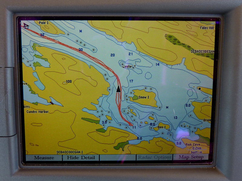

0.3 nm Scale - Hey Where Did The Land Go??:
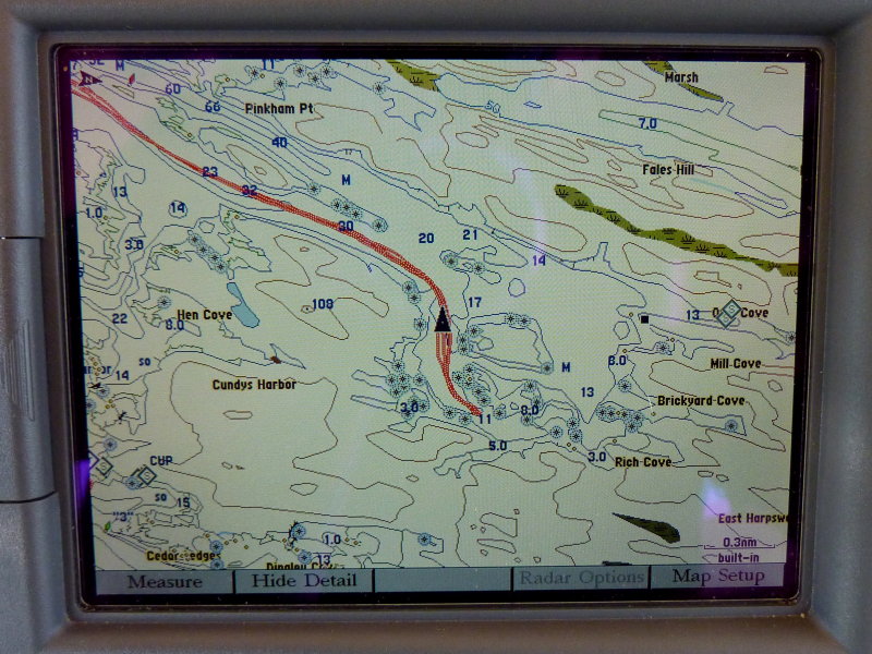

0.5 nm Scale - Land, Land, Bueller, Bueller.........:
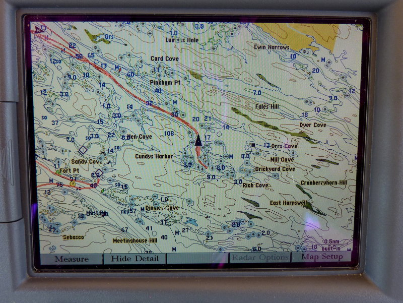

0.8 nm Scale - Oh there you are land..........
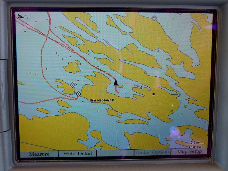

Check out the 108 foot deep spot on the 0.3 & 0.4 nm scales.... Oh yeah that's a hill not a harbor.....:D:D

I find it amusing when people pay such homage to a particular brand like they are infallible or something. None of them are and they ALL make mistakes. My NOAA charts have never lost the islands or land on me..;) I love my Gamin stuff but like most brands it is not perfect...
 
Feb 2, 2010
373
Island Packet 37 Hull #2 Harpswell Me
I get tucked in between Snow and Little Snow and have never once noticed the land disappearing on my Garmin 740. I find the paper charts are best for planning a route when you can see the whole picture without having to zoom in and out.
Is NOAA to blame or is it the fault of the manufacturers?
 
Feb 6, 1998
11,760
Canadian Sailcraft 36T Casco Bay, ME
I get tucked in between Snow and Little Snow and have never once noticed the land disappearing on my Garmin 740. I find the paper charts are best for planning a route when you can see the whole picture without having to zoom in and out.
Is NOAA to blame or is it the fault of the manufacturers?
It's not NOAA's fault it is the data programmers who do the charting for Garmin who made the error. These errors often get fixed in the next revision, probably fixed in yours, but then different ones show up. One revision showed us anchored on land at one of our favorite coves but on the HH plotter it was perfect...

If you begin paying very close attention you can find errors on just about any brand of cartography. Our Raymarine and Northstar plotters were famous for dropping rocks at varying zoom's.... At one scale the awash rock was there then zoom to the next one and it was gone...
 
Jun 6, 2006
6,990
currently boatless wishing Harrington Harbor North, MD
Are you suggesting that we use GPS to navigate at the "very much smaller than a mile" level? I beleive that the best practice calls for "going visual" in close quarters as soon as practical/possible.
GPS is great and can give you a lot of data not avalable with out it but it is not a precision navigation tool and was never meant to be one for civilian use. Perhaps if you are anchoring near a precision landing equipped airfield and have the WAS turned on you could but I'm thinking that would be the exception not the rule.

I find that my OpenCPN program does not "drop rocks" when using raster charts. It does when using vector charts though. I find the raster to be easier on the eyes in all cases. I'm thinking that youall are using vector charts as raster can't "drop" anything as it is just a picture and does not turn on/off items based on zoom level.
 

RichH

.
Feb 14, 2005
4,773
Tayana 37 cutter; I20/M20 SCOWS Worton Creek, MD
GPS chartplotters are vulnerable to major errors of 'resolution' .... trying to use a magnification scale greater than the original 'base' data of the actual survey.

Another example of a resolution error would be driving an automobile while looking through binoculars.
 
Jul 28, 2010
914
Boston Whaler Montauk New Orleans
Another example of a resolution error would be driving an automobile while looking through binoculars.
I think I saw a couple of those people on my way in to work this morning. ;)
 
Jun 6, 2006
6,990
currently boatless wishing Harrington Harbor North, MD
Driving while using binos is not a resolution issue RichH. It is an example reduced bandwidth (reduced field of vision) and an excellent example of natural selection at work.
 
Nov 6, 2006
10,220
Hunter 34 Mandeville Louisiana
Interesting.. I have a Garmin 545 and I don't have a problem with land disappearing, but it shifts things a bit in some areas.. In the top right corner of Lake Pontchartrain, it tracks us clearly up in the swamp instead of in the middle of the bayou.. About a 150 foot distance.. There is a place in the North Shore Channel where it shows the channel displaced by a couple of hundred feet .. Back in the LORAN days, this was a place with bad "crossing angles" of the TD lines. That generated errors in positioninng of about the magnitude noted in the Garmin.. My suspicion is that they used a TD-to-coordinates translator to encode the vector charts and the errors were replicated ?? I dunno.. This is one with built in-charts that don't upgrade with normal upgrades.. I'll document to Garmin via the link and see what they say..
 
Feb 26, 2004
23,362
Catalina 34 224 Maple Bay, BC, Canada
RTFM from Garmin or any other chart plotter.

Maine Sail's point is NOT whether you use visuals or "all other means of navigation" including your HEAD (the one on your shoulders :)).

It IS, as I read it, meant for those folks who rely completely on their screens as opposed to using all other means of information available.

Get your eyes off the screen-only.

Understand the limitations of the instrumentation you have.

Pretty simple. Disappearance of features simply because of difference zoom scales is just as bad as being in a different place on the screen than you know you really are.

I think this is just a nice, well written and presented WARNING to the screen-slaves and paper-less sailors that may be out there (present company excluded, of course).

Thanks, Maine Sail.
 
Feb 6, 1998
11,760
Canadian Sailcraft 36T Casco Bay, ME
Are you suggesting that we use GPS to navigate at the "very much smaller than a mile" level? I beleive that the best practice calls for "going visual" in close quarters as soon as practical/possible.
Not at all I am merely suggesting that these devices are not as perfect as some make them out to be and people should use them as PART of their navigation system not as the entire system.

As for "very much smaller than a mile" you've clearly never spent much time in Maine...:) These devices are very accurate when everything is working as it should and the screens are working properly, about 98-99% of the time as I experience it.

I regularly blip my radar right over a nun or can which is right there on the screen and all line up within a few feet.. Rocks, islets, awash rocks are most often the same and we have hundreds of thousands of them along this coast.... In Maine you are very often below 1nm screen resolution and it is still very, very accurate...

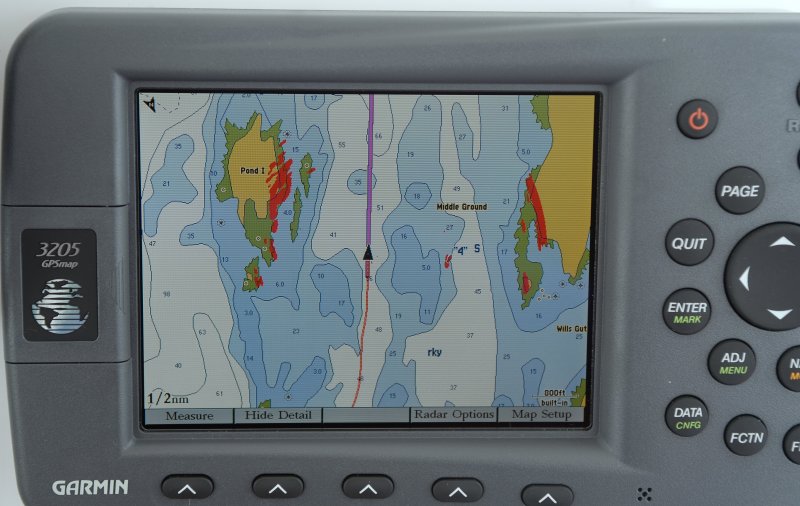
This is what it is like most of the time. Note the accuracy of the red nun with radar overlay, and this is at the 800 foot resolution...


GPS is great and can give you a lot of data not avalable with out it but it is not a precision navigation tool and was never meant to be one for civilian use.
You're kidding right...? I can't even draw a pencil line on most charts thin enough to equal the accuracy I regularly see with my plotter. My WAAS is almost always enabled though not always picking it up. Still the accuracy of these devices is astounding and far greater than I could ever DR or plot manually.

I find that my OpenCPN program does not "drop rocks" when using raster charts. It does when using vector charts though. I find the raster to be easier on the eyes in all cases. I'm thinking that youall are using vector charts as raster can't "drop" anything as it is just a picture and does not turn on/off items based on zoom level.
Most all plotters use vector and some do a better job than others but they all miss the mark occasionally, just as paper does. I know of MANY uncharted rocks and obstacles on this coast that NOAA/paper never picked up either that is why I also rely on "local knowledge". If it's not on paper it's not on your plotter, and if it's on paper it's likely on your plotter but there is no 100% guarantee.

FWIW my Garmin has been far more accurate in chart accuracy, rendering and not missing objects than my Raymarine C-80 and Northstar 952X ever were... I believe the Northstar and the C-80 used Navionics. Accuracy was not the issue, when the data was there they were almost always spot on, it was missing data such as rocks or depth contours that was the frustrating part..
 
Jan 22, 2008
280
Hunter 25_73-83 NORTH POINT MARINA/WINTHROP HA IL
I cannot imagine dispensing with paper charts. Although I have succumbed to the new technology, I always use paper charts when going into unfamiliar areas and keep a DR plot/fix to mark my way. This along with eyeball navigation is an excellent and safe practice to avoid the above problems you mentioned. When we sail at night, we use exclusively paper charts and depending upon our proximity to shore, plot fixes every 1/2 hour to 1 hour intervals. I am amazed how many sailors cannot dead reckon or plot fixes but rely solely on their chart plotters. Good point. Good luck and good sailing, Ron
 
Jun 6, 2006
6,990
currently boatless wishing Harrington Harbor North, MD
I got it on the accuracy MS. My point is when GPS goes south and you have been "watching the screen" you will be in a world of hurt as you already know.
My GPS goes off line about once every time I go out. Course, I live in Navy test ranges and they do some weird stuff so my experience is probably different than most.
 
Feb 6, 1998
11,760
Canadian Sailcraft 36T Casco Bay, ME
I got it on the accuracy MS. My point is when GPS goes south and you have been "watching the screen" you will be in a world of hurt as you already know.
My basic point...:)

My GPS goes off line about once every time I go out. Course, I live in Navy test ranges and they do some weird stuff so my experience is probably different than most.
We had the Brunswick Naval Air base only a few miles awy and still we never lose our GPS signal. Since 1997 I don't recall that I ever lost my signal. That sucks if you lose it often. The only time I have lost reception it was the fault of the antenna connection or the GPS device..
 
Feb 2, 2010
373
Island Packet 37 Hull #2 Harpswell Me
My Garmin gpsmap 740 has never lost a signal, is accurate within a minute of warm up and i always display the accuracy, usually its 9 feet, you cant ask for much more. But unless satellites start to be replaced, i think the accuracy will worsen.
 

Ross

.
Jun 15, 2004
14,693
Islander/Wayfairer 30 sail number 25 Perryville,Md.
On a standard 80,000:1 chart the point of my dividers is bigger than my boat. A .5 mm lead pencil makes a mark 133 feet wide. If the chart plotters do better than that and you need that accuracy then by all means use it.
 
Jun 3, 2004
298
'79 Hunter 33' HUN33190M79L Olympia
A friend of mine isn't too impressed with GPS for some reason, as if paper charts involve LESS time with your nose buried in the chart.
 
Jun 6, 2006
6,990
currently boatless wishing Harrington Harbor North, MD
Well Stephen, I just put mine on the cockpit seat and look at it from time to time. No buttons to press or cursors to manipulate or waypoints to locate and select. Certianly don't have to turn the thing off/on or adjust light levels and contrast. i do occiosionally have to turn the page but sometimes I can get the wind to do that for me.
I find those "sign here" post-it stickers handy at marking both course and position.
The one thing I think is very useful is the annotations on the paper chart that I can't ever seem to find on the electronic vector ones. You know, stuff like the names of things. those come in pretty handy in an emergency when I can say I'm (eyeballing it) a mile SE of xxx marina about 50 yards from shore.... I find most folks can rattle off the Lat-long without too much difficulty but those boats that might help have no idea of how to plot that one their fancy GPS to tell them where that is in relation to them. that makes gps somewhat less than useful IMO as if you can give me a precise location but I can't tell where that is what is the point? If I have to futs around for 10 minutes trying to find your location provided I had the presence of mind to have a pencil and paper at hand (my chart is paper BTW) and was able to write down the numbers as they where blasted out.
 
Status
Not open for further replies.