• Sailing is all about the Weather.

    Big into the exploration of Atlantic Hurricanes since Katrina came uninvited into his world, James (Jim) Gurley (JamesG161) has followed every Tropical Storm birthed in Atlantic, Gulf and Caribbean waters since. Being a boater, he knows that we often need more time to prepare than we get from the TV weather folk. Jim relies on the science of storm development to share early warning info with friends and fellow boaters.

    Early in 2018, Jim and John Shepard, (JSSailem) started to chat about the weather data available. John asked Jim to help forecast Pacific NW storms, and this morphed into discussions on weather forecasting.

    For John, sailing in the PNW is sometimes hit and miss. One day is ugly, then a string of beautiful days but no wind, followed by a series of blue-sky days and 12 knot breezes. Being ready for those great sailing days means you need to look to the Pacific Ocean and what is brewing. John has been into Pacific NW Weather since the 1970’s when his first PNW November storm hit bringing more than 40 days and 40 nights of continual rain.

    Together we want to share information, new APPs, safety, and thoughts about letting the weather help you. Identify some of the resources for sailors and help prepare you for your next sailboat outing.

    It is far better to go out on the water knowing what to expect in weather terms, than to be out on the water and see dark ominous clouds suddenly appear, unprepared.

The ENSO Climate affect on our Weather....

Oct 22, 2014
21,084
CAL 35 Cruiser #21 moored EVERETT WA
Since the 1600's Chilean Fishermen (Paita sailors) have talked about El Niño (the Christ child), the warm currents that affected their fishing grounds occurring around Christmas.

The study of the ENSO (El Niño Southern Oscillation) currents has intensified as we continue to attempt to forecast the weather. No longer willing to be satisfied with, it is Mother Nature or God that is causing our rain/sunshine. We seek to identify causal events that provide us forecastable weather conditions.

There are great NOAA web sites that provide a multitude of tools to help inform us of the observed causal weather that has occurred when ENSO currents push or pull the warm waters of the Southern Pacific East or West. These movements of warm water also affect the winds we sailors value, especially the Jet Stream. The movement of the Pacific Jet Stream or the Polar Jet Stream influences the steering of the Low and High Pressure cells we watch to determine should be bundle up and expect snow or grab our gear and head to the boat for a great day sail.

Here are a few of the NOAA websites to explore.
1. El Niño Southern Oscillation (ENSO) NWS JetStream - El Niño Southern Oscillation (ENSO)

1637524258585.png


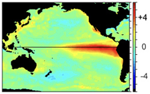
Change in sea surface temperature from normal during an El Niño. From December 1997, this image shows the change of sea surface temperature from normal. The bright red colors (water temperatures warmer than normal) in the Eastern Pacific indicates the presence of El Niño.

2. El Niño The El Niño Southern Oscillation (ENSO) is one of the most important climatic phenomena on Earth
El Niño | National Oceanic and Atmospheric Administration

3. United States El Niño Impacts https://www.climate.gov/news-features/blogs/enso/united-states-el-niño-impacts-0

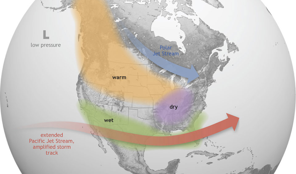
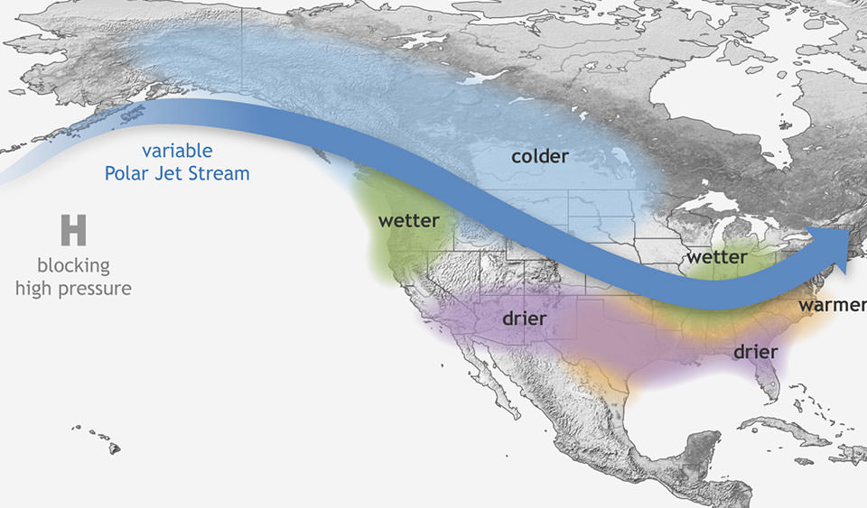
I like the global images of this link ( What are El Nino and La Nina?). It helps to identify the type of weather patterns we experience in winter as a result of the ENSO currents.

EL Niño Current - Winter Weather in the US
1637524384953.png


La Niña Current - Winter Weather in the US
1637524395777.png


The Weather Guys....
John and Jim
 

dLj

.
Mar 23, 2017
3,414
Belliure 41 Sailing back to the Chesapeake
Just spent a bit of time going through the attached links - extremely interesting! Thank you very much for such great info!

dj
 
  • Like
Likes: JamesG161
Oct 22, 2014
21,084
CAL 35 Cruiser #21 moored EVERETT WA
The ENSO events are not uniform.
They occur during the winter/spring time frame in the Equatorial Pacific. These events affect the weather in Pacific NW and the rest of North America 6-7 months later. It is one of those "butterfly flapping it's wings" type of phenomena.

1637787315236.png

Sea surface temperature across the tropical Pacific Ocean in December 1997 (top), during a strong El Niño, and in December 1988 (bottom) during a strong La Niña. The ONI only tracks the temperatures in the Niño3.4 region, but during strong events, the entire central and eastern tropical Pacific will generally become warmer or cooler than average. Maps by NOAA Climate.gov, based on data from NOAA's Physical Science Lab.
In examining this observed Pacific Ocean events, I am wondering what is the initiator triggering ENSO activity. Why is this not a cyclical event? Why are there more El Niño's than La Niña's?

A few thoughts:
  • More than 70 per cent of the earth’s surface is covered by the oceans.
  • The Pacific Ocean is the largest and deepest ocean. Combined the Pacific, Indian and the Southern Oceans make up 70% of the ocean surfaces on Earth.
  • What happens in these waters determine world weather patterns.
  • The ENSO events are a part of the weather generating patterns for the Indian and Pacific oceans - as well the coasts that identify their limits.
  • What happens in the North Pacific determines the weather patterns for North and Central America
So what are the affects of the El Niño current patterns on weather patterns in the world.
1637786097775.png

These are general weather patterns.

One of the mechanics along the Equatorial Pacific that creates these weather patterns, is what is called the Hadley Circulation.
1637786246051.png


"When an El Niño causes excess heating in the tropical Pacific upper atmosphere, the air flow toward the poles becomes more vigorous. The change in the strength of the Hadley circulation leads to modifications in the circulation patterns worldwide" How ENSO leads to a cascade of global impacts BY ANTHONY BARNSTON PUBLISHED MAY 19, 2014

Spring Time 2021 was the year of La Niña. It La Niña that is bringing us the wet weather up here in the PacificNW this winter.
In La Niña years the ENSO currents push the warm Ocean waters to the west. These warm waters pile up in the area north and east of Australia.
1637787096800.png

Generalized Walker Circulation (December-February) anomaly during La Niña events, overlaid on map of average sea surface temperature anomalies. Anomalous ocean cooling (blue-green) in the central and eastern Pacific Ocean and warming over the western Pacific Ocean enhance the rising branch of the Walker circulation over the Maritime Continent and the sinking branch over the eastern Pacific Ocean. Enhanced rising motion is also observed over northern South America, while anomalous sinking motion is found over eastern Africa. NOAA Climate.gov drawing by Fiona Martin. Generalized Walker Circulation (December-February) anomaly during La Niña events, overlaid on map of average sea surface temperature anomalies. Anomalous ocean cooling (blue-green) in the central and eastern Pacific Ocean and warming over the western Pacific Ocean enhance the rising branch of the Walker circulation over the Maritime Continent and the sinking branch over the eastern Pacific Ocean. Enhanced rising motion is also observed over northern South America, while anomalous sinking motion is found over eastern Africa. NOAA Climate.gov drawing by Fiona Martin.

Still unsure of the trigger that starts this ENSO system generating the El Niño or La Niña events. I am sure that the energy from the Sun is the only possible source that can affect that much water to change the temperatures.
 
Oct 22, 2014
21,084
CAL 35 Cruiser #21 moored EVERETT WA
In November we explored the ENSO oscillation El Nińo/La Niña patterns. Saying it will affect our weather in specific ways.

Now here in December, the Pacific NW and even Northern California are getting the wet/snowy weather that is associated with summer La Niña current. Interesting is the pattern of upper level winds. These winds drive the high/low pressure cells we monitor for local weather conditions.

Taking a look at this weeks coming polar jet pattern the track is almost a copy of the NOAA expected pattern for La Niña conditions.
Here is Sunday image of the forecast for the polar jet at the 9000 meter level.
1640714906104.png


And here is the NOAA forecast for La Niña seasonal patterns.
IMG_9512.jpg
 

dLj

.
Mar 23, 2017
3,414
Belliure 41 Sailing back to the Chesapeake
Dang, I'm on my phone these are hard to see well. Where do I find the key to the top image colors?

dj
 
Oct 22, 2014
21,084
CAL 35 Cruiser #21 moored EVERETT WA
On Windy.
White is the polar jet over 100knts.
yellow is 22 knts
Lt green 12 knts
blue 0 knots.

Think of it like a topographic map of wind speed.
72E207C4-EA4F-4DC3-8F9F-91E6A05DDA09.jpg