- Oct 22, 2014
- 23,794
SEA TEMPERATURES and Storm Development
We need to understand some basics about sea temperatures before we can start using the data to conjecture what may be happening with storm development.
This is the beginning of a series of posts on this thread to develop a basic understanding of how sea surface temperature (SST) affects our sailing experiences.
BASIC - Current Sea Surface Temperatures. SST
The process of gathering SST samples is a testament to human ingenuity. Satellites, Buoys, Drones, and land-based sites, each with its unique capabilities, are all contributing to our understanding of water temperatures and storm development.
A current look at the Western Atlantic shows that the water temperatures in the Caribbean are about 30ºC [ 86°F].
Look at all the Red, and one might think the sky is falling. However, recognize this is a single snapshot in time.
The source of Energy that provides the Sea Surface Temperature SST is our Sun.
Note that the comparison below is against an Average over the range of tempertures from 1981- 2010.
Look at the current SST and apply historical references to compare present conditions with historical storm development records.
Are the SSTs the same as when Katrina was forming in this part of the ocean?
Based on scientific observation, we have decided that the SST is an essential element to consider regarding the development of all storms.
Looking at today's SST data and comparing these Temperatures to those of the past seven days, are there any changes occurring?
The development of SST over time creates a window into the potential for a specific storm to become a threat or to remain a rain producer, eventually wearing itself out over the water.
When we begin to examine a Low cell with the potential to develop into a tropical depression, we always examine the current SST data.
The above images come from the NOAA analytical data available on several weather sites.
Next, on our weather adventure, we will explore Ocean Heat.
Weather and Forecasting
Jim and John
We need to understand some basics about sea temperatures before we can start using the data to conjecture what may be happening with storm development.
This is the beginning of a series of posts on this thread to develop a basic understanding of how sea surface temperature (SST) affects our sailing experiences.
BASIC - Current Sea Surface Temperatures. SST
The process of gathering SST samples is a testament to human ingenuity. Satellites, Buoys, Drones, and land-based sites, each with its unique capabilities, are all contributing to our understanding of water temperatures and storm development.
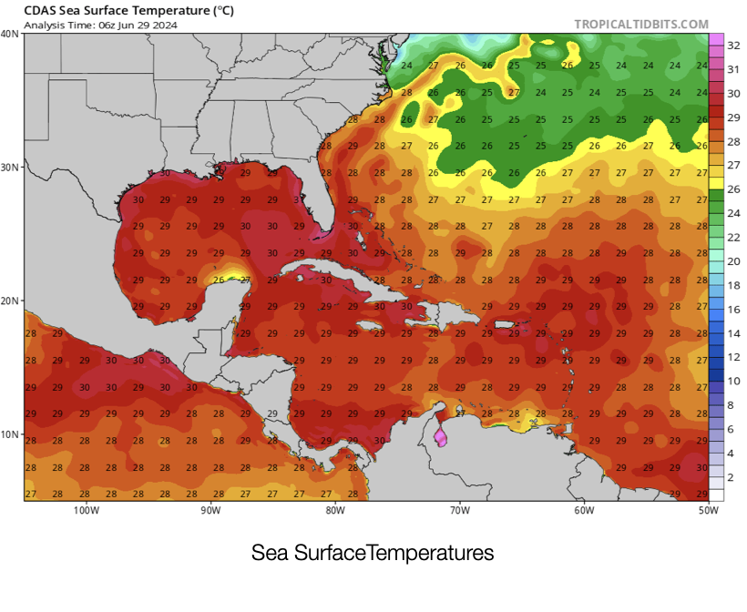
A current look at the Western Atlantic shows that the water temperatures in the Caribbean are about 30ºC [ 86°F].
Look at all the Red, and one might think the sky is falling. However, recognize this is a single snapshot in time.
The source of Energy that provides the Sea Surface Temperature SST is our Sun.
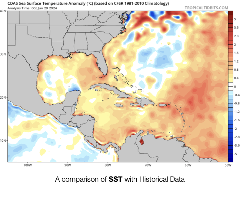
Note that the comparison below is against an Average over the range of tempertures from 1981- 2010.
Look at the current SST and apply historical references to compare present conditions with historical storm development records.
Are the SSTs the same as when Katrina was forming in this part of the ocean?
Based on scientific observation, we have decided that the SST is an essential element to consider regarding the development of all storms.
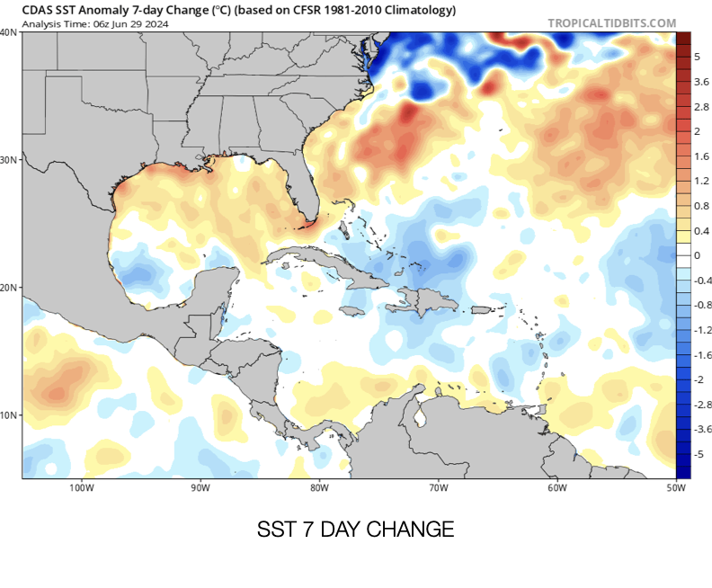
Looking at today's SST data and comparing these Temperatures to those of the past seven days, are there any changes occurring?
The development of SST over time creates a window into the potential for a specific storm to become a threat or to remain a rain producer, eventually wearing itself out over the water.
When we begin to examine a Low cell with the potential to develop into a tropical depression, we always examine the current SST data.
The above images come from the NOAA analytical data available on several weather sites.
Next, on our weather adventure, we will explore Ocean Heat.
Weather and Forecasting
Jim and John

