• Sailing is all about the Weather.

    Big into the exploration of Atlantic Hurricanes since Katrina came uninvited into his world, James (Jim) Gurley (JamesG161) has followed every Tropical Storm birthed in Atlantic, Gulf and Caribbean waters since. Being a boater, he knows that we often need more time to prepare than we get from the TV weather folk. Jim relies on the science of storm development to share early warning info with friends and fellow boaters.

    Early in 2018, Jim and John Shepard, (JSSailem) started to chat about the weather data available. John asked Jim to help forecast Pacific NW storms, and this morphed into discussions on weather forecasting.

    For John, sailing in the PNW is sometimes hit and miss. One day is ugly, then a string of beautiful days but no wind, followed by a series of blue-sky days and 12 knot breezes. Being ready for those great sailing days means you need to look to the Pacific Ocean and what is brewing. John has been into Pacific NW Weather since the 1970’s when his first PNW November storm hit bringing more than 40 days and 40 nights of continual rain.

    Together we want to share information, new APPs, safety, and thoughts about letting the weather help you. Identify some of the resources for sailors and help prepare you for your next sailboat outing.

    It is far better to go out on the water knowing what to expect in weather terms, than to be out on the water and see dark ominous clouds suddenly appear, unprepared.

Remanent of Karen <--TS Karen

Feb 14, 2014
7,399
Hunter 430 Waveland, MS
TS Karen popped up over night in an area of high Heat content.

Karen's arrival spot is not good.

Of the multitude of activity in Late September...

TS Karen

should be considered a Wild course one.

storm_12.gif


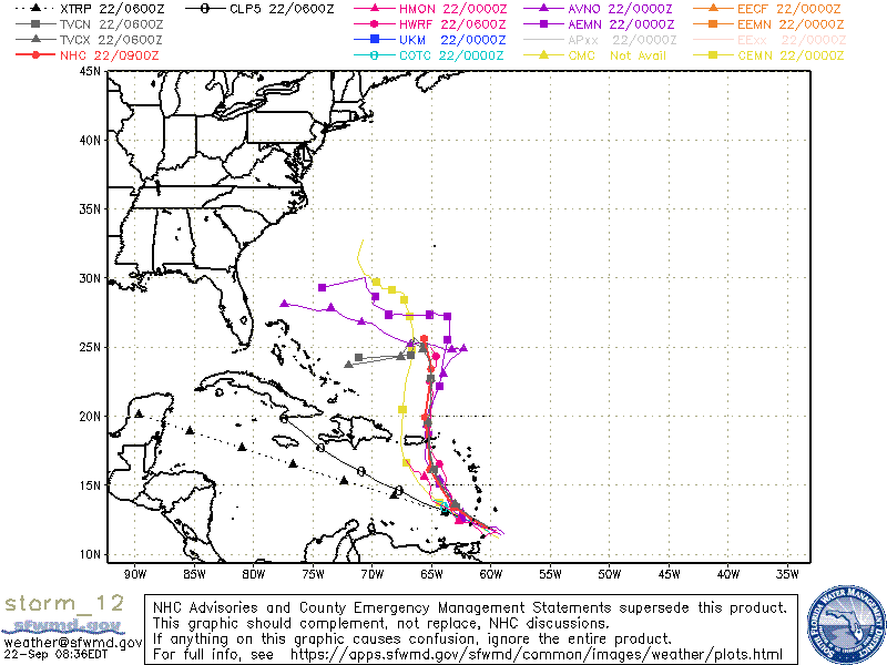
TVCN is a 3 component model who has a good tracking within 72 hours [± 25 nm] Grey Triangle SQUARE.

What is BAD is the West Curve at 96 hours.

Depends on the eastward HIGHs timing on late Monday 23rd for better idea.

TS Karen does have a Gulf entry potential.

Dammit Jim...
 
Last edited:
Oct 19, 2017
7,732
O'Day 19 Littleton, NH
What's going on at 25N lat, that the models see a sharp 90 deg turn?

-Will (Dragonfly)
 
Feb 14, 2014
7,399
Hunter 430 Waveland, MS
TS Karen is following behind TS Jerry which means low intensity for now.

But...

A small HIGH may cut in between them.
This may block and stall TS Karen.

Timing is everything.

Dammit Jim...

PS: That HIGH may Whack Karen and eliminate it. Keep a weather eye on Karen.
 
Last edited:
Nov 18, 2010
2,441
Catalina 310 Hingham, MA
Tell me about. In Bequia. We went to bed feeling good and I woke up at 5 am to see Karen. Spent the next 3 hours prepping the boat and now the waiting game. Its just about 2 pm and all we have seen are some scattered showers but really swirly, gusty winds; 4 knots from the NE; 10 minutes later it's 25 knots from the S; 10 minutes later 15 knots from the ESE, 10 minutes later 35 knots from the S again. Been like that for over 3 hours. We took a mooring for the location, a far up in the bay as possible and almost 360 protection. But the mooring is in 30 feet. So I started my prep with an hour of freediving to put chain and shackles on the mooring to secure some spots I didn't like. Sails wrapped, everything off the deck or lashed down. Now we are just watching and waiting. We are prepared for anything up to a Cat 1. But we have had to use the motor several times to avoid hitting other boats as we all are swinging very differently. More stern to stern to stern pass then I ever remember on a mooring.

Fair winds all!

Jesse
 
  • Like
Likes: JamesG161

DaveJ

.
Apr 2, 2013
449
Catalina 310 Niagara-on-the-Lake
A little self serving here, but my wife's name is Karen. I could get a lot of mileage out of a hurricane with her name!
Better than a major depression.....

Cheers
dj
 
Oct 22, 2014
20,989
CAL 35 Cruiser #21 moored EVERETT WA
:laugh:
Why not Dave. Not sure how calling her a Hurricane works...
 
Feb 14, 2014
7,399
Hunter 430 Waveland, MS
People asked why the turning West on the 26th...
This is the Forecast , not by NOAA, but the European composite.

EM 26th.png


Those 2 HIGH can split and it looks like the One over TN [today 23rd is the HIGH shown off NC on the 26th], will move to block TS Karen.

Depend on movements those HIGHs , they could Force Karen toward Bahamas and West.

Dammit Jim...
 
Last edited:
  • Like
Likes: jssailem
Feb 14, 2014
7,399
Hunter 430 Waveland, MS
This is NOAA's prediction on those HIGHs for the uncertainty....

GPS 26th.png


For long term forecast or 3 days+++
The European models are the best. Close to Land NOAA is best.
Jim

PS: NOAA says Karen gets Whacked.:clap:
 
  • Like
Likes: jssailem
Feb 14, 2014
7,399
Hunter 430 Waveland, MS
NOAA says Karen gets Whacked
Definition of Whacked:
Look at the HIGH off North Carolina on post 11. The winds are circulating Clockwise and a Big pressure of 1017mb.
Poor Karen is just a LOW wimp of 1011mb [this is about sea level standard pressure]. Winds are circulation Counter Clockwise.

Who wins the fight?:hook2::poke:
Jim...
 
  • Like
Likes: jssailem
Nov 26, 2008
1,966
Endeavour 42 Cruisin
This guy does great descriptions of the variables that will affect various tropical storms. Excellent work.


DanC

.
Nov 19, 2014
5
Oday 222 Lake Somerville, TX
Uh, what DaveJ said. My wife's name is also Karen (With this crowd though, I should make it clear that DaveJ and I are NOT married to the same woman.)


As far as I know...
So.........has Karen been making a bunch of "Business trips" lately????????? Thankfully Kathleen is not in the name rotation this year! She's been known to cloud up and storm on me every now and then!
 
Feb 14, 2014
7,399
Hunter 430 Waveland, MS
The Hurricane Hunters are flying through Karen now.

Models for that blocking HIGH vary wildly. [above Post #10]

Too soon for use to make a call.

By Thursday morning we will know about the fate of TS Karen.
Jim...
 
  • Like
Likes: jssailem