New
- Thread starter pumpkinpie
- Start date
I have RM and like it. B&G is more race/sail oriented - Being that old your current instruments are most likely SeaTalk. Current instruments use NMEA 2000, which is just starting to be phased into an Ethernet version. All major vendors are N2K even the SeaTalkNG ones. If your sounder/paddle wheel/wind sensors are still ok - you can save $$ by installing an ITC5 from RM which will get them on SeaTalkNG a conversion cable from N2K
If you have a below deck auto pilot that can also be reused - just get a ne controller. The new ones like the RM EVO are so much better than previous generation.
If your getting RADAR the important thing is get one with Doppler. Then desire if you want a pole on the stern or mount on the mast. Mine is on the stern.
Also get AIS Transmit - it allows the big commercial boats to “see” you.
I also recommend getting an engine monitor from either Actisense or NolandEngineering (RS11, I have this for my old M25 Universal). This puts the gauges up at the helm where their readable, and alarm thru the MFD’s.
I also recommend using a single vendor if possible, so you can update firmware and configure things.
In addition to my RM I have a few Yacht Devices products (temp, barometer, logger, WiFi bridge).

I don’t think you have to stay with one brand. I have raymarine ST60 instruments, Raymarine EVO 200 AP course computer, Raymarine ST70 AP Control head, and B&G MFD with Lowrance BR24 broadband radar. My AP drive is Whitlock.
I have converters to convert Seatalk to NMEA 0183, to SeatalkNG, to NMEA2000, to Simnet. The BR24 radar uses Ethernet to talk direct to the B&G MFD.
The NMEA 0183 also talks to a YakBitz NMEA0183 to Wi-Fi converter to feed iOS apps over wireless.
My class B AIS transceiver is a WestMarine AIS 5000 which feeds AIS and GPS to my Uniden VHF (with foghorn and wireless remote) and the B&G MFD. The AIS 5000 also feeds AIS and GPS info on NMEA 0183 via a 9-pin serial port at the navigation table so I can plug in my laptop (using a USB to serial converter) running Coastal Explorer nav software. I also run a Navionics chart chip in my B&G CP.
It all plays together, reliably, proved for years.
Get what you want. I think a big consideration which would influence a decision is if the new instruments don’t fit the old holes in the mounting panels. You can cover the old panel with a new one but that adds time and expense if you do it right so it looks professional.
http://yakbitz.com/Default.aspx
Last edited:
@pumpkinpie yes you budget is fine. The problem with going with lots of vendors is being able to configure and update firmware. These two actions have not been standardized by the NMEA standard. So if you get a RM autopilot or ITC5 you can only update the firmware on either using a RM chart plotter and you need a RM MFD to configure the ITC5. Same with other vendors. The RS11 and Yacht Devices can be configured with a PC (some YD need a generic chart plotter).
Hunter faucets and partsAnd now a word from the sponsor...
Replacement fixtures, hoses, sprayers, washers, and more.
See the product
Geeze. All I can say to that is that Admiral and I sailed out of Bayboro Marina, St. Petersburg (Tampa Bay) along the coast and through the waterways of southwest FL between Pine Island Sound and Tarpon Springs for 11 yr using a binnacle compass, depth finder, pair of Fujinon 8x30s, a paper chart kit of southwestern FL, and the local cruising guide, with occasional help from a finicky LORAN C unit. No RADAR, no GPS, no AIS, and certainly no supersized cockpit chartplotter.I have RM and like it. B&G is more race/sail oriented - Being that old your current instruments are most likely SeaTalk. Current instruments use NMEA 2000, which is just starting to be phased into an Ethernet version. All major vendors are N2K even the SeaTalkNG ones. If your sounder/paddle wheel/wind sensors are still ok - you can save $$ by installing an ITC5 from RM which will get them on SeaTalkNG a conversion cable from N2K
If you have a below deck auto pilot that can also be reused - just get a ne controller. The new ones like the RM EVO are so much better than previous generation.
If your getting RADAR the important thing is get one with Doppler. Then desire if you want a pole on the stern or mount on the mast. Mine is on the stern.
Also get AIS Transmit - it allows the big commercial boats to “see” you.
I also recommend getting an engine monitor from either Actisense or NolandEngineering (RS11, I have this for my old M25 Universal). This puts the gauges up at the helm where their readable, and alarm thru the MFD’s.
I also recommend using a single vendor if possible, so you can update firmware and configure things.
In addition to my RM I have a few Yacht Devices products (temp, barometer, logger, WiFi bridge).
There’s not much fog in SW Florida around Tampa Bay, hardly any. So, RADAR isn’t needed as in foggy venues. Probably why the boat does not have one already. Regrettably, a lot of one’s transit along that coast is via the ICW. So, with a paper chart and binoculars you just read the numbers on the daymarks to find out where you are in the channels. The markers are not so far apart that you need a chartplotter to stay in the channel. Twisty channels may have range markers to assist.
The commercial Bruisers are not in the ICW. The ones that come up Tampa Bay do so toward the middle, pretty far from sailing areas on the west side. There aren’t that many of ‘em. Not like here in Long Beach. At the Sunshine Skyway Bridge you may wish to wait to let one through, rather than pass under the bridge span. He doesn’t really need to see you. He’s staying in the dredged channel (otherwise he’s aground). You need to see him, and know where you are relative to the marked channel, etc. It’s your job to stay out of his path; stay out of the channel when one is coming in. You don’t need RADAR for that. Cruising along the coast you principally need to know your depth to estimate your distance from shore lacking GPS or other fixes.
So. The most important navigation equipment cruising SW Florida is paper chart, guide book, depth finder, binnacle & hand bearing compass, and binoculars. A small hand-held GPS would, of course, be VERY useful and I do recommend having one or two aboard. Certainly cannot hurt. But, you’re not talking thousands of dollars here. Wait until you decide to go somewhere where you need all of that e-capacity. For more fun, you’ll want a good dinghy and reliable outboard.
Last edited:
Something germane from Kretschmer’s new book. Chapter 5 “Just Enough Technology.”
“But technology is greedy—one development begets another, and if you’re not careful the blind pursuit of the next gadget can snuff out the essential joy of sailing as your precious time is wasted chasing electrical faults, software meltdowns, and all of the technological annoyances that you were trying to escape by going sailing in the first place.”
“Pulling your head out of the screens and closely examining your watery environment has the almost magical power to change a dull, two-dimensional screen view of a passage into a three-dimensional masterpiece, resplendent with sounds and smells as well.”
Last edited:
Kind of depends where you will travel as to what you need. We sail a lot to the Keys and east and west coasts of Florida, Bahamas, etc. I would not leave home without radar. A couple of years ago we had heavy fog from Marathon to Naples: two day trip. Thank goodness we had radar. The other feature we really like is AIS. Wish all boats had it: it would be better than radar.
We have all Raymarine and would recommend you stick with on brand even though you could mix a couple. Its hard enough trouble shooting with one brand. Would not want to try with multiple brands. You can save some money with a smaller display for your MFD. You can also use an Ipad for a back up. I have Garmin Blue Charts on my Ipad.
We have all Raymarine and would recommend you stick with on brand even though you could mix a couple. Its hard enough trouble shooting with one brand. Would not want to try with multiple brands. You can save some money with a smaller display for your MFD. You can also use an Ipad for a back up. I have Garmin Blue Charts on my Ipad.
You can save scarce electrons, too. Bigger screens draw more power. That's important unless you motor a lot or have a huge solar array.You can save some money with a smaller display for your MFD
Key point of #8 above.It’s hard enough trouble shooting with one brand. Would not want to try with multiple brands.
@Captain Larry-DH yes different brands can interoperate quite well thanks to NMEA standards. Unfortunately the instruments are getting more and more like computers rather than dedicated hardware that has no firmware, and calibrate using potentiometers. Put a RM autopilot in and BG chart plotter, and you’ll be sending the pilot into RM if you need a fix to the firmware. Calibrate an ITC5 for depth offset requires a RM plotter. Same holds tube for both B&G and Garmin. I believe Radars only work with like chart plotters unless you got tons of space and go with dedicated display.
I get no joy using paper charts and hand held compasses - can I do DR? Yup but to me it’s more fun to monitor progress using the plotter and electronics. For sure I’m much safer.
But to each their own, if people want to sail with Compass and lead lines -that’s great, but don’t think I’m less of a sailor if I use modern electronics.
Les
Too many toys for this skipper. Our 1991 boat came with the ST-50 suite of wind angle/speed, depth, speed through the water and a below deck Autohelm ST-7000 autopilot. All still work and very useful. Fam got me a Garmin 178C Sounder for my 2005 birthday in order to help the skipper avoid the assortment of hazards the skulk beneath the water surface. It has saved my nickers more than once. I have it connected to the autopilot, which does a better job staying on course than the skipper who can easily get distracted from this and that. These have worked quite well over the many years of cruising PNW waters in all kinds of weather conditions.
Radar, AIS, EPIRB, etc. would be nice to have, but have yet to encounter a need for these devices. In retrospect, maybe a day will come when those niceties become necessities. I'll keep a peeled eye for that moment. Had no idea at the time that the 178C would become so useful. Perhaps these other doohickies carry the same expectation.
I suppose if one were to really get down to basics a knotted/weighted rope could be used for speed and depth, compass, paper charts, calipers, and above all a sextant for calculating position. Of course, since the sun never shines here, that would present a bit of a dilemma.
Last edited:
Paper charts are more than simply a place onto which one plots a position or course. They are tremendous reservoirs of nautical information that should be continuously studied. In e-format they are not nearly as interesting and may lack detail. I sometimes sit at the nav station while at anchor with a cup of coffee or tea and just gaze at the paper chart of the area, absorbing bits of detail about where we lay.
Right now and for the past several days I have me chart of San Luis Obispo Bay, Port San Luis open on the nav table. I look at where the rocks are, the kelp, the points, the shape and curvature of the shoreline, etc. Just lots of detail. I take note that soundings are in feet (not fathoms or meters). I know I’m lying in an area where the depth is generally 22 to 32 ft, no rocks or kelp very near, but where there is a sewer line lying 0.2 n.mi. east of me out (seaward) to 32 ft. Bottom is sand. I’m inside demarcation, but not in a Special Anchorage. For example.
Right now and for the past several days I have me chart of San Luis Obispo Bay, Port San Luis open on the nav table. I look at where the rocks are, the kelp, the points, the shape and curvature of the shoreline, etc. Just lots of detail. I take note that soundings are in feet (not fathoms or meters). I know I’m lying in an area where the depth is generally 22 to 32 ft, no rocks or kelp very near, but where there is a sewer line lying 0.2 n.mi. east of me out (seaward) to 32 ft. Bottom is sand. I’m inside demarcation, but not in a Special Anchorage. For example.
Last edited:
I just upgraded my solar from 210 watts to 370w. Huge improvement in recovery time - this morning at about 08:00 the ammeter showed we were charging the house bank at plus 8 to 10 amps while the fridge is running (it draws 3.2A with compressor on).
I did it myself.Did you do the install yourself or contracted out? And what was the over all cost? Thank you
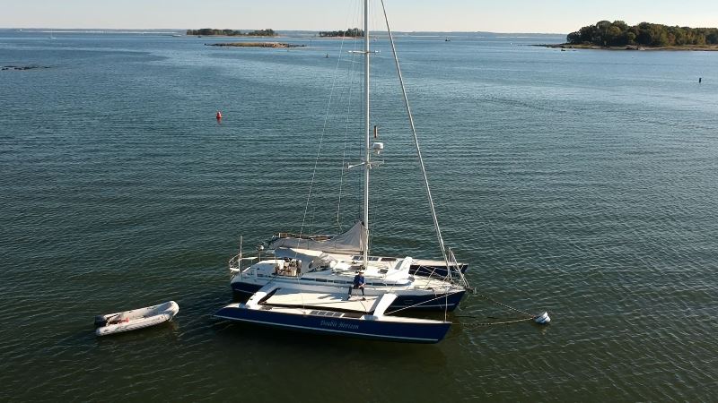
In 2008 I installed four (4) 20-watt panels on each side of my boat (the amas of a trimaran) for a total of 160 watts, and last year I added a 50-watt Lensun flexible panel on deck in front of my mast (210 total). That wasn't enough. I found 160 watt panels (made by Renogy) on Amazon that exactly fit the available space on the decks of my amas and decided to buy those. I had to upgrade my solar charge regulator capacity. I am using a Morningstar Sunsaver MPPT 15 Amp unit, so I added a second one and ran the panels from each side to it's own dedicated regulator, and the 50w center panel also gets its own regulator, a Xantrax C12 PWM unit. These regulators also feature a load circuit with a low-voltage-disconnect. I power my fridge from one of those, so it can't run the batteries flat.
This is one of the 160w panels (with sea salt crystals on it).
This aerial image shows the older panels. The 50w panel in front of the mast was added after this image (it can be walked on):
Last edited: