• Sailing is all about the Weather.

    Big into the exploration of Atlantic Hurricanes since Katrina came uninvited into his world, James (Jim) Gurley (JamesG161) has followed every Tropical Storm birthed in Atlantic, Gulf and Caribbean waters since. Being a boater, he knows that we often need more time to prepare than we get from the TV weather folk. Jim relies on the science of storm development to share early warning info with friends and fellow boaters.

    Early in 2018, Jim and John Shepard, (JSSailem) started to chat about the weather data available. John asked Jim to help forecast Pacific NW storms, and this morphed into discussions on weather forecasting.

    For John, sailing in the PNW is sometimes hit and miss. One day is ugly, then a string of beautiful days but no wind, followed by a series of blue-sky days and 12 knot breezes. Being ready for those great sailing days means you need to look to the Pacific Ocean and what is brewing. John has been into Pacific NW Weather since the 1970’s when his first PNW November storm hit bringing more than 40 days and 40 nights of continual rain.

    Together we want to share information, new APPs, safety, and thoughts about letting the weather help you. Identify some of the resources for sailors and help prepare you for your next sailboat outing.

    It is far better to go out on the water knowing what to expect in weather terms, than to be out on the water and see dark ominous clouds suddenly appear, unprepared.

Invest 99L --> TD 9 --> TS Ida --> Hurricane Ida

Feb 14, 2014
7,399
Hunter 430 Waveland, MS
Investigation 99L is a Tropical wave birthed in the Caribbean.

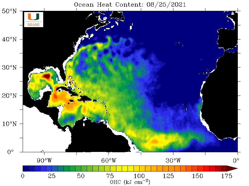
The Tropical Waves off Africa have been weak from low HEAT fuel.

The Caribbean has plenty of HEAT!

ohc_aQG3_latest_natl-2.gif


The Tracking models are still weak, but if it enters the Gulf of Mexico, land impact looks possible.
Saturday the 28th, models will tell the story and we probably see the Hurricane Hunters first flight into Invest 99L.

The LOW pressure front over Kansas today, will move East at ≈ 10 mph, and create the path of least resistance for Invest 99L to follow.

I know you get tired of us saying...

Prepare Now!

Jim...

PS: John and I are updating our boat preparation list, and will soon post it for other to contribute their ideas.
PSS: August 28th is the Anniversary of Hurricane Katrina land impact.
 
Last edited:
Feb 14, 2014
7,399
Hunter 430 Waveland, MS
All the major models agree that Invest 99L will enter the Gulf of Mexico and have a USA land impact.

Likely to hit land as Hurricane Ida.

The storm appears to miss the disruptive land as it passes through the Yucatan Channel.

The Gulf Stream is providing the HEAT Fuel to quickly build the storm.

Hurricane Hunters will fly probably on Friday to provide the best information. After their mission, the Tracking models will be very close together.

Jim...
 
Feb 14, 2014
7,399
Hunter 430 Waveland, MS
Tropical Depression 9 has had the first Hurricane Hunter Flight into the Storm.

recon_AF301-0109A-CYCLONE.png


It was a low level flight to find the circulation, which they did find.

No Dropsponde Buoy done.

mission5.jpg

My guess they are waiting for TD 9 going in to the Gulf of Mexico, Friday Morning, for the best Storm data.

So this is applause for them.

patch53d.gif

:clap::clap::clap::clap::clap:

Jim...
 
  • Like
Likes: jssailem
Oct 26, 2010
1,881
Hunter 40.5 Beaufort, SC
BOHICA Gulf Coast! Thanks Jim for the update and those in the path, be prepared and our thoughts and prayers are with you if the Gulf heat builds this into a big storm.
 
  • Like
Likes: jssailem
Oct 26, 2010
1,881
Hunter 40.5 Beaufort, SC
@JamesG161 I know you are probably busy getting ready for this storm so no need to respond. Just hoping that now you are back in the water (I think that is the case) everything works out favorably in riding this one out better. Be safe.
 
Feb 14, 2014
7,399
Hunter 430 Waveland, MS
Update on Tropical Storm Ida...

Hurricane Hunters and NOAA aircraft are alternating storm passes.

recon_AF301-0409A-IDA.png

Note MUCL which is an Airport showing West winds and 20 knts.
The HH flight notes Hurricane winds on the NE side.

Best tracking view so far...
IdaNC1.jpeg


I like this View from Mariners version from NowCoast.
This show the steering winds for the storm.

The Bad news is the HEAT- Fuel Source Path.
ohc_aQG3_latest_natl-4.gif


Right over the Gulf Stream Fuel depot as the HIGH pressure moves East at ≈10mph.:facepalm:

This shows the Gulf Stream currents.

geovel_aQG3_latest_natl.carib-2.gif


When TS Ida enters the Gulf they can predict Eye wall land fall within 50 miles. My guess Sundown tonight.

Prepare now!!
BOAT PREPARATION IDEAS for Storms

Dammit Jim...
 
May 1, 2011
4,187
Pearson 37 Lusby MD
Just saw a forecast of category 4 (major) hurricane as Ida sucks energy out of the Gulf. Getting scary indeed! Stay safe.
 
Last edited:
Feb 14, 2014
7,399
Hunter 430 Waveland, MS
Hurricane Ida has a well formed Eye, and is over Cuba now.

Major intensification expected, as it is HEAT fueled by the Gulf Stream, on it's project path. [See Graphic of Heat above]

The next Hurricane Hunter flight through, is the key one. They are on the Runway at Kessler Air Force Base [Biloxi] now.

Their flight will tell Locals Officials of Eye landfall within 50 miles.

Listen to Local Officials, since they have a direct connection with FEMA. [yes, FEMA has control]

All major models are showing the same landfall swath. No need for us to show the swath.

Now projected a Cat 4 landfall.

The EYE central pressure is projected to be 960 kPa or millibars.
[Note the lower the central pressure the higher the winds. Katrina was 828 kPa]

DAMMIT Jim...
 
Feb 14, 2014
7,399
Hunter 430 Waveland, MS
Hurricane Ida is in the Gulf and is behaving as Forecast.

IDA 2.jpeg


I am not going to do much more on this storm, but give you a few links to watch the Storm Surge. [NOAA definition]

These will be Wind, Pressure and Water Level
Station Home Page - NOAA Tides & Currents
Very close to Landfall point.;);)

This is on the East Side of storm, so it should be the highest Surge.
Station Home Page - NOAA Tides & Currents

Thanks to all SBO friends for their kind thoughts and hopes for good luck.

We SBO Sailors that normally Contribute here and are within the Hurricane IDA path area...
@kloudie1 , @BigEasy stay in touch behind the scenes.

This is an average Storm Surge for us.
Station Home Page - NOAA Tides & Currents

DAMMIT JIM....
 
Oct 22, 2014
20,989
CAL 35 Cruiser #21 moored EVERETT WA
IDA is still building. Land fall still expected somewhere just west of Grand Isle

15 mile eye has formed. Listing is a Category 4 Hurricane. Winds range from 130 to 156 mph.

Interesting Satellite photo this morning from Windy. Showing the eye of the storm. You can look down through the center and view the ocean.
IDA Satellite Image.jpg
 
Nov 6, 2006
9,884
Hunter 34 Mandeville Louisiana
I am trying to find the Hurricane Hunter data from the sondes .. The links disappeared from "spaghetti models" and I did some googling and can't find the mission reports. Where did they go, John?
 
Nov 6, 2006
9,884
Hunter 34 Mandeville Louisiana
Perfect ! Many Thanks..
Looks like 40-50 where my boat is right now.. I just got a note that the power is off at the slip..