Invest 96L now Hurricane Maria
- Thread starter JamesG161
- Start date
-
- Tags
- hurricane season
Diamondhead Marina. It is 3 miles from our house. The Pass Harbor would be my 2nd choice. Both Harbors have great Restaurants.where do you keep your boat
Jim...
PS: The tallest mast in the link picture is our boat.
")
96L is probably going to go Tropical by Monday 18th and models show it beginning to the Mid Season Atlantic "curve" to the North West.
Steering winds are not favorable for a massive storm unless it Stalls out.
This will be next News Cycle storm.
Jim...
Steering winds are not favorable for a massive storm unless it Stalls out.
This will be next News Cycle storm.
Jim...
Even though there area destructive winds opposing TS Maria, she became Tropical by Satellite data only.
______
The bad news..
There are two LOWs over central USA that appears to be timed such to draw TS Maria into them. If that happens Maria will make a slow North West Turn as she passes over the Islands.
The good news....
The steering winds are strong going EAST. Also the middle level winds still are opposing her and may kick her strength DOWN.
Jim...
The national News cycle now has Maria in their news.
Listen for information on the Diameter of the Eye wall for the best info. The Category rating is Maximum sustained winds. I look at the Hurricane Hunters's data for Intensity information.
Prepare along East Coast now.
Jim..
Listen for information on the Diameter of the Eye wall for the best info. The Category rating is Maximum sustained winds. I look at the Hurricane Hunters's data for Intensity information.
Prepare along East Coast now.
Jim..
This is data taken from a Hurricane Hunter's mission earlier today and put into a very clear way to view winds.
It becomes obvious why NOT to take the Eye Wall HIT.[shown in RED]
A storm's Category Rating is great for News hype, but Maria is Compact destructive compared to many bigger storms.
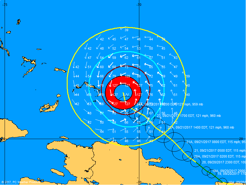
Note the previous circle's Eye Walls.
Jim...
It becomes obvious why NOT to take the Eye Wall HIT.[shown in RED]
A storm's Category Rating is great for News hype, but Maria is Compact destructive compared to many bigger storms.
Note the previous circle's Eye Walls.
Jim...
For you Course Model watchers, here is the GFS modeling prediction of Steering winds for Oct 1, 2017.
You can see why HIGH pressures are somewhat a shield to LOW pressure Hurricanes.
Can you visualize the Trough or path of least resistance?
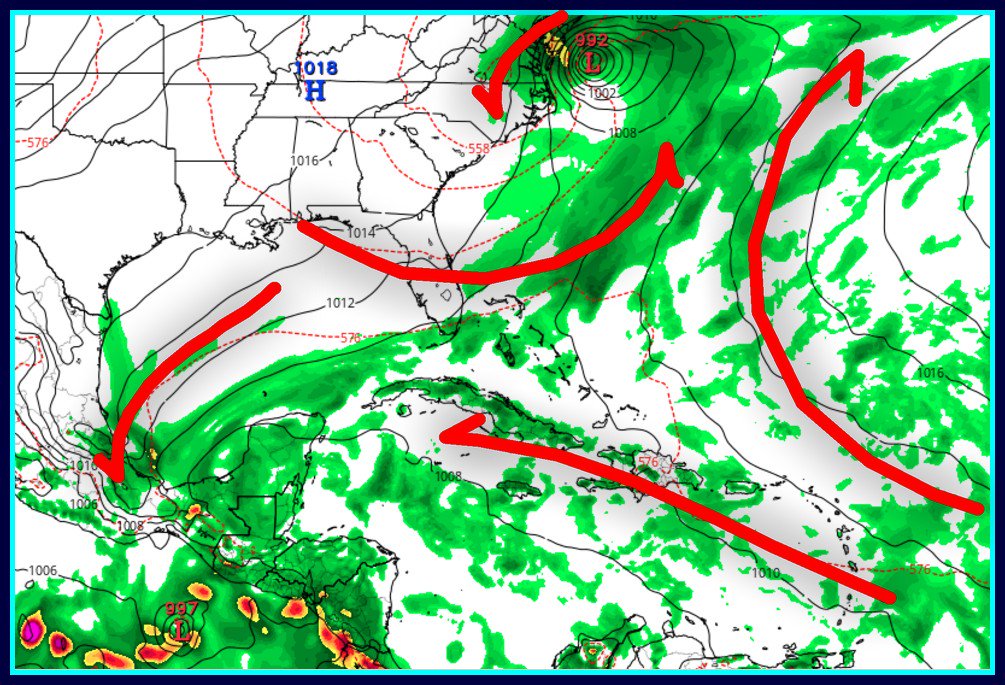
Jim...
You can see why HIGH pressures are somewhat a shield to LOW pressure Hurricanes.
Can you visualize the Trough or path of least resistance?
Jim...
I try to plan mine for when I'm sailingHmmmm? I wonder why Maria will make a sudden Eastward turn soon?
Timing of HIGH's is everything.
Jim...
. Wed morning, I see it is finally turning east, lower than 73 latt..
Last edited:
On previous posts, I have posted a the Sea Temperature Anomaly picture which indicates the current surface temperature versus a long term average on Today's date. This is a basic view of Energy Content of water.
What caught my attention was the HUGE amount of energy Hurricane Maria removed from the Atlantic. We all agree just don't dump that energy on People.
Note the now BLUE or cooler path Maria took.
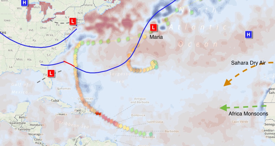
We are now in the last month of 2017 season.
Sahara desert air is drying the African monsoon season air. Hopefully no more African birthed cyclones heading west. The path has be well de-energized by previous storms, cyclonic or not.
Bye bye... Maria.
Jim...
What caught my attention was the HUGE amount of energy Hurricane Maria removed from the Atlantic. We all agree just don't dump that energy on People.
Note the now BLUE or cooler path Maria took.
We are now in the last month of 2017 season.
Sahara desert air is drying the African monsoon season air. Hopefully no more African birthed cyclones heading west. The path has be well de-energized by previous storms, cyclonic or not.
Bye bye... Maria.
Jim...
Correction.We are now in the last month of 2017 season.
".... Last monthS" Oct and Nov...
Jim...