-
Sailing is all about the Weather.
Big into the exploration of Atlantic Hurricanes since Katrina came uninvited into his world, James (Jim) Gurley (JamesG161) has followed every Tropical Storm birthed in Atlantic, Gulf and Caribbean waters since. Being a boater, he knows that we often need more time to prepare than we get from the TV weather folk. Jim relies on the science of storm development to share early warning info with friends and fellow boaters.
Early in 2018, Jim and John Shepard, (JSSailem) started to chat about the weather data available. John asked Jim to help forecast Pacific NW storms, and this morphed into discussions on weather forecasting.For John, sailing in the PNW is sometimes hit and miss. One day is ugly, then a string of beautiful days but no wind, followed by a series of blue-sky days and 12 knot breezes. Being ready for those great sailing days means you need to look to the Pacific Ocean and what is brewing. John has been into Pacific NW Weather since the 1970’s when his first PNW November storm hit bringing more than 40 days and 40 nights of continual rain.
Together we want to share information, new APPs, safety, and thoughts about letting the weather help you. Identify some of the resources for sailors and help prepare you for your next sailboat outing.It is far better to go out on the water knowing what to expect in weather terms, than to be out on the water and see dark ominous clouds suddenly appear, unprepared.
Invest 95L --> TD 13 --> TS Lee --> Hurricane Lee --> PTS Lee
- Thread starter JamesG161
- Start date
And an even more concerning picture from the GFS for day 12 -This is GFS model forecast for 10 day from today.
Although at 12 days out the forecast probably shows the one thing that won’t happen.
jssailem
SBO Weather and Forecasting Forum Jim & John
- Oct 22, 2014
- 24,454
One must remember. These are future projections of a mathematical historical model with dynamic fluid events happening over the period identified. Much beyond 3-5 days the reliability of the model begins to vanish.Although at 12 days out the forecast probably shows the one thing that won’t happen.
But it is fun to… What if?
This is the reason it will be a Major Storm.
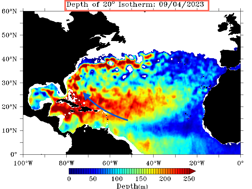
Hurricane Fuel or Stored Solar HEAT.
Normally we show just the top ±10 feet of HEAT, but 3 Satellites combined can estimate how Deep that HEAT is stored.
I like this format better, to predict Storm Intensity. The 20°C or 68°F Isotherm.
PS: What we normally show

Hurricane Fuel or Stored Solar HEAT.
Normally we show just the top ±10 feet of HEAT, but 3 Satellites combined can estimate how Deep that HEAT is stored.
I like this format better, to predict Storm Intensity. The 20°C or 68°F Isotherm.
Jim...The next 5 days will tell us more.
PS: What we normally show

Me rooting for this storm to head North of me is like talking to your golf ball after you've hit it.
jssailem
SBO Weather and Forecasting Forum Jim & John
- Oct 22, 2014
- 24,454
Rick... If you are still in "Pt Judith" is way to early to be concerned about the sky falling over Rhode Island.Lee looks like really bad juju
"Lee" is announced. It will be traveling over some of the same water that 95L traveled. It is starting in a similar position in the Atlantic. What it will be come is way to early to conjecture. We have really no idea of the "juju" it has or will develop. 10 days in the future this is what the upper level winds look like - dragging the storm east into the Central Atlantic.
It certainly bears watching and could become a problem. 5 days from now we will have a better opportunity to identify the risks.
Stay tuned. James and I are watching the development of the Atlantic storms. Always fun to have participants join in and help us focus attention on what is brooding out there.
THANK YOU.
It is the reason we devote our time to this Weather and Forecasting forum.
James and John
Dammit and ScarFace
Here in Florida it's all about evacuation. You can't stay for a Cat 4 or above. Problem is you don't know in time to evacuate if the storm will be that intense or not. In this case the forecast it's a Cat 4 , less than 200 miles away. Pucker time! Maybe a time to drive to Sebring.
And thanks to the Hurricane Team for what insights they can give!
And thanks to the Hurricane Team for what insights they can give!
My bad, I counted to 13 on one hand after drinking 4 Beers [ hic hic hic].But will soon be name Hurricane Margot.
It will be Hurricane Lee
and yes....
Dammit Jim...
And thank you for your work.....Rick... If you are still in "Pt Judith" is way to early to be concerned about the sky falling over Rhode Island.
"Lee" is announced. It will be traveling over some of the same water that 95L traveled. It is starting in a similar position in the Atlantic. What it will be come is way to early to conjecture. We have really no idea of the "juju" it has or will develop. 10 days in the future this is what the upper level winds look like - dragging the storm east into the Central Atlantic.
View attachment 219580
It certainly bears watching and could become a problem. 5 days from now we will have a better opportunity to identify the risks.
Stay tuned. James and I are watching the development of the Atlantic storms. Always fun to have participants join in and help us focus attention on what is brooding out there.
THANK YOU.
It is the reason we devote our time to this Weather and Forecasting forum.
James and John
Dammit and ScarFace
My bad, I counted to 13 on one hand after drinking 4 Beers [ hic hic hic].
It will be Hurricane Lee
and yes....
Dammit Jim...
Better than trying to count to four after thirteen beers.
Now that’s scary; forecasting while intoxicated!!My bad, I counted to 13 on one hand after drinking 4 Beers [ hic hic hic].
It will be Hurricane Lee
Isn't that how the NHC does their forecasts?Now that’s scary; forecasting while intoxicated!!

Indeed! Any chance the high over the center of the US will be able to block?TS Lee should not Fear, Hurricane Margot will follow his Rear.
View attachment 219588
Double Dammit Jim...
jssailem
SBO Weather and Forecasting Forum Jim & John
- Oct 22, 2014
- 24,454
The thought of a savior brings hope to many a weather watcher.
Too early to tell. The GFS and Euro models are not in agreement as to the path of LEE. I am working on some analysis this AM.
Too early to tell. The GFS and Euro models are not in agreement as to the path of LEE. I am working on some analysis this AM.
Tks!The thought of a savior brings hope to many a weather watcher.
Too early to tell. The GFS and Euro models are not in agreement as to the path of LEE. I am working on some analysis this AM.
