Pretty sure the people who make iNavX have doubled down on iOS and dropped their Mac development for good. Some say this is the direction Apple is heading as well. I too relied heavily on GPSNavX on my MacBook but I ended up buying the base model iPad with a $10 pointer and I find it works really well. All routes and waypoints can be exported in one click and imported on your iPhone.I got excited when it said it worked on the MAC version of iNavX. Then iNavX canceled their Mac software. But there maybe hope. The new version of MAC OS has given developers a way of exporting their IOS apps to MAC. Time will tell if this is a future or vaporware.
iNavX and CHS Charts
- Thread starter YVRguy
- Start date
There are a couple of other options for tablet/phone nav programs.
Embark (www.letsembark.io) uses C-Map cartography and cloud based storage the app is free, the charts are reasonably priced. The program can be used online for free. With an account the routes and waypoints are saved and downloaded to any devices, including some chart plotters, when connected to the cloud. It is nice to sit in front of a large computer screen and plan the trip and then download it to the tablet. The charts are all vector charts.
Aqua Map (Aqua Map - Marine GPS, Boating Charts, Lake Maps) is a tablet/phone app that is free. Charts are downloaded in sections and appear to be reasonably priced. Folks on the ICW like the app because it uses crowd sourced depth information. Good for areas that frequently shoal.
I have used Embark and like it. It is easy to use and has an auto route feature and it integrates well with my B&G electronics. The one downside I have found is cross platform integration requires an internet connection.
I only learned of the Aqua Map program after the boat was hauled, haven't used it yet.

jssailem
SBO Weather and Forecasting Forum Jim & John
- Oct 22, 2014
- 24,504
I agree that iNavX works well on the iPad. I have the Apple Pen and it helps with locating a way point.
While I like and use iNavX, it is not as robust or easy to use as the Coastal Explorer software. Additionally, CE is constantly updating the Chart software to the current charts, a feature that I like.
While I like and use iNavX, it is not as robust or easy to use as the Coastal Explorer software. Additionally, CE is constantly updating the Chart software to the current charts, a feature that I like.
So where would Navionics get their canadian chart info if it wasn’t CHS?I know this wasn't directed at me but I can say with certainty they are better than Navionics if you are thinking of accuracy and detail. CHS charts are required in paper form for all boat traffic in Canada and are the only ones used by commercial shipping. The case for Navionics charts is more around usability. For example, Navionics will automatically select the appropriate chart as you zoom in to a particular location. The CHS charts must be manually switched as you move or zoom. Also, Navionics charts show more points of interest for recreational boaters.
I use both charts for their relative strengths but for certain I would never navigate around a reef or other hazardous areas without the CHS charts.
jssailem
SBO Weather and Forecasting Forum Jim & John
- Oct 22, 2014
- 24,504
I came across this website..
I-Boating...
Appears you can use the site online. If you want to decouple from the web you need to buy the app and the appropriate map data.
Any one have any experience with this software. Looks similar to iNavX. It works on a MAC.
I did note that there is a disclaimer regarding use as a navigation tool in Canadian Waters.
I-Boating...
i-Boating : Free Marine Navigation Charts & Fishing Maps
i-Boating: Marine navigation app with nautical charts, hi-res lake depth maps, Fishing AI, routing, and weather. Works on iOS, Android, Windows, Mac, Linux, and Raspberry Pi.
fishing-app.gpsnauticalcharts.com
Appears you can use the site online. If you want to decouple from the web you need to buy the app and the appropriate map data.
Any one have any experience with this software. Looks similar to iNavX. It works on a MAC.
I did note that there is a disclaimer regarding use as a navigation tool in Canadian Waters.
23. Notices for derived charts using CHS data are given below. You must agree to these notices to use these charts.
This product has been produced by Bist LLC based on Canadian Hydrographic Service (“CHS”) data, following any minimum standards/guidelines that may have been established by CHS, pursuant to CHS Digital Value-Added Reseller Agreement No 2012-0612-1260-B.
The incorporation of data sourced from CHS in this product shall not be construed as constituting an endorsement by CHS of this product.
This product does not meet the requirements of the Charts and Nautical Publications Regulations under the Canada Shipping Act. Charts and publications issued by or on the authority of CHS, must be used to meet the requirements of those regulations.
Just for grins..I asked the question on the Raymarine forum if their Lighthouse charts have disclaimers and if they knew of anybody who has charts without disclaimers..
“I am aware of no producers of nautical cartography for recreational marine electronics / navigation which offer use of their products without liability disclaimers. Raymarine's MFDs running LightHouse 3 and LightHouse II software are compatible with Raymarine's LightHouse Charts (available from Raymarine's Charts Store), LightHouse NC2 Charts (purchased from Raymarine dealers), Navionics cartography, and C-Map cartography.
LightHouse Charts are produced from BSB formatted raster and vector charts of both government hydrographic offices (ex. US NOAA Raster, US NOAA Vector, Brazil Raster Charts, Fugawi Aboard Canada (under license from Canadian HO, etc.) and privately produced raster charts (ex. N.V. Atlas charts, Imray, etc.). All LigthHouse Charts are subject to the Limitations of Use dialog acknowledged within LigthHouse 3 and LightHouse 2 software as well as the End User License Agreement for LightHouse Charts.
MFDs running LightHouse II and LightHouse 3 software are also compatible with Navionics cartography and C-Map 4D Max cartography, the use of which is also subject to acknowledgement of the LightHouse 3/II Limitations of Use dialog and any terms of use specified by Navionics and C-Map respectively.”

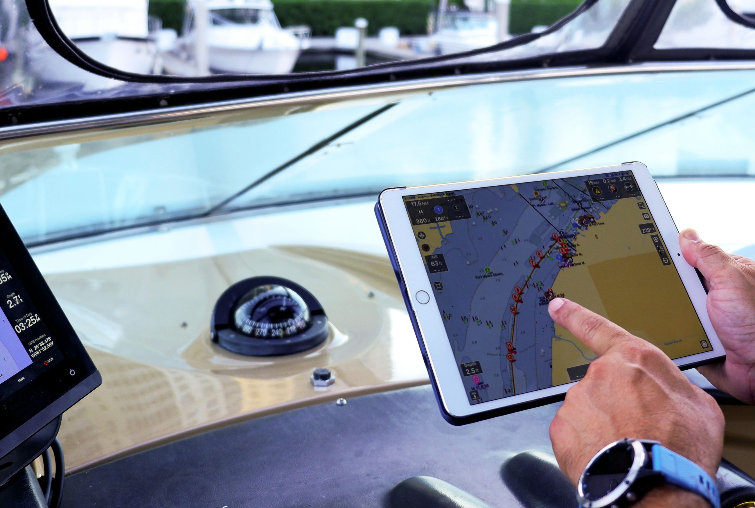
In the examples I provided, both charts are showing maximum detail on a relatively small area. (In case you didn't notice, the charts show Sea Otter Cove, which is the first anchorage after rounding Cape Scott).What happens when you zoom in with Navionics?
With Navionics charts, one of the advantages is you get more detail by just zooming in - it will automatically switch to more detailed charts until maximum detail is reached. With CHS, if you want more detail you need to manually switch to a more detailed chart by hitting the "+" button until you have the best chart available for that area.
It's interesting that the two charts show different depths for the same area (the CHS Charts are in meters). One of the user-friendly features of Navionics is they point out with an icon the ideal spot to anchor. I thought that was pretty helpful considering how remote the location is.
Last edited:
crowd sourced depth information are in Navionics Sonar Chart, Aqua Map integrates the USACE (US Army Corps of Engineers) Surveys and yes, in ICW is a game changer.There are a couple of other options for tablet/phone nav programs.
Embark (www.letsembark.io) uses C-Map cartography and cloud based storage the app is free, the charts are reasonably priced. The program can be used online for free. With an account the routes and waypoints are saved and downloaded to any devices, including some chart plotters, when connected to the cloud. It is nice to sit in front of a large computer screen and plan the trip and then download it to the tablet. The charts are all vector charts.
Aqua Map (Aqua Map - Marine GPS, Boating Charts, Lake Maps) is a tablet/phone app that is free. Charts are downloaded in sections and appear to be reasonably priced. Folks on the ICW like the app because it uses crowd sourced depth information. Good for areas that frequently shoal.
I have used Embark and like it. It is easy to use and has an auto route feature and it integrates well with my B&G electronics. The one downside I have found is cross platform integration requires an internet connection.
I only learned of the Aqua Map program after the boat was hauled, haven't used it yet.
Digital Aids Simplify ICW Navigation
New Info Includes Corps of Engineers Dredging Reports
 www.passagemaker.com
A few valuable boating apps, and what's your favorite?
Most boaters carry around an impressively powerful and easy to use computer in their pockets: their smartphone. Smartphones have enough processing power, sensors and capabilities to augment or possibly even replace dedicated navigation equipment onboard your boat. Mobile phone and tablet apps...
www.panbo.com