• Sailing is all about the Weather.

    Big into the exploration of Atlantic Hurricanes since Katrina came uninvited into his world, James (Jim) Gurley (JamesG161) has followed every Tropical Storm birthed in Atlantic, Gulf and Caribbean waters since. Being a boater, he knows that we often need more time to prepare than we get from the TV weather folk. Jim relies on the science of storm development to share early warning info with friends and fellow boaters.

    Early in 2018, Jim and John Shepard, (JSSailem) started to chat about the weather data available. John asked Jim to help forecast Pacific NW storms, and this morphed into discussions on weather forecasting.

    For John, sailing in the PNW is sometimes hit and miss. One day is ugly, then a string of beautiful days but no wind, followed by a series of blue-sky days and 12 knot breezes. Being ready for those great sailing days means you need to look to the Pacific Ocean and what is brewing. John has been into Pacific NW Weather since the 1970’s when his first PNW November storm hit bringing more than 40 days and 40 nights of continual rain.

    Together we want to share information, new APPs, safety, and thoughts about letting the weather help you. Identify some of the resources for sailors and help prepare you for your next sailboat outing.

    It is far better to go out on the water knowing what to expect in weather terms, than to be out on the water and see dark ominous clouds suddenly appear, unprepared.

Hurricane Delta <--- TS Delta

Feb 14, 2014
7,418
Hunter 430 Waveland, MS
This was Invest 92L.

This Storm will have land impact on the Gulf Coast.:facepalm:

The current models are predicting a merging of TS Gamma or at least a directional effect of pulling it North West.

Both storms are removing Heat energy in the form of lot of RAIN.

ohc_naQG3_ddc-9.gif


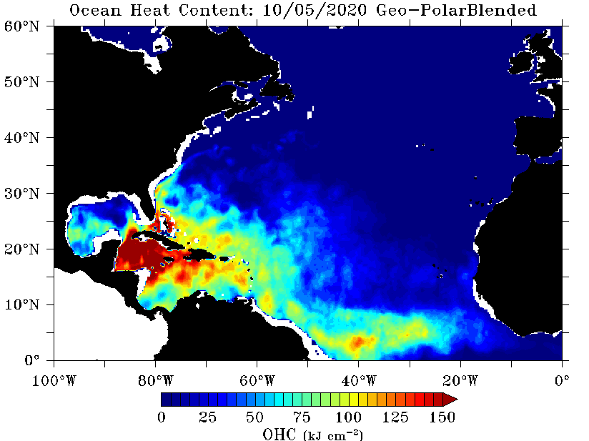
TS Delta will gain most of its energy during its path through the hot Caribbean.

We will not show tracking models until Tuesday, but there are two major HIGH pressure cells that will guide its turn to the North East.
One large cold HIGH from Canada and one smaller HIGH from the PNW will create the LOW path to follow.

Dry Air from the Polar Jet Stream and yes even from the Sahara Desert are damping this storm.
Jim...

PS: The good news is African Birthed Storms should not have a USA land impact for the rest of 2020.;)
PSS: From the Heat Energy plot above, can you see where these storms were born?
 
May 1, 2011
4,238
Pearson 37 Lusby MD
Looks like it has the potential to mess up my long weekend! Not gonna say your two favorite words just yet. :beer:
 
  • Ha
Likes: JamesG161
Jun 21, 2004
2,533
Beneteau 343 Slidell, LA
Looks like it has the potential to mess up my long weekend! Not gonna say your two favorite words just yet. :beer:
Same here! Going to mess up my long awaited week in Pensacola. Depending on storm track, may leave Florida on Wednesday and head back home. Boat is still in “storm mode” with canvas removed and extra lines. Unplugged power before leaving yesterday, so no additional prep necessary.
Hope this is last one in Gulf for 2020; at this rate, may not re-rig until November.:(:(
 
  • Like
Likes: JamesG161
Feb 14, 2014
7,418
Hunter 430 Waveland, MS
Hurricane Delta is a tight and compact storm at 140 mph winds. It is sucking out HEAT in the always HOT South Caribbean.

What we pointed out in our first post still holds true.

Note the flight path of the Hurricane Hunter's mission. The numbers are where they dropped weather buoys.
recon_NOAA9-0526A-DELTA_dropsondes-2.png

That path was to verify that the Storm would move to the North West.
recon_NOAA9-0526A-DELTA-2.png
The results

Watch this NOAA buoy now.
NDBC - Station 42056 Recent Data
Dammit Jim...

PS: from Tropical Tidbits
 
  • Helpful
Likes: Will Gilmore
Jan 1, 2006
7,069
Slickcraft 26 Sailfish
A data point: Looking at sea temps for Oranjestad Aruba the current temp is 84.1 F. Statistical past temps for that area in October are 83.3 to 85.9F. While that warmth would probably support development of tropical weather, it is not excessively hot compared to past data. TWC keeps banging on how warm the Southern Caribbean is, but at least near Aruba it is not out of the normal range.
 
May 24, 2004
7,131
CC 30 South Florida
Florida should be clear, actually the storm will suck out the humid air and it being replaced with nice dry air and slightly cooler temperatures. It is headed NW to the Yucatan Peninsula and then will head N for a land fall around Louisiana. Intensity will depend on what happens in the Yucatan and its forward speed once it moves back over the Gulf waters.
 
Feb 14, 2014
7,418
Hunter 430 Waveland, MS
This is the real key to strengthening.

HEAT and not Surface temperatures.

Also how DEEP the HEAT is.

Near Surface Heat with the best tracking model....
DeltaTrack.gif


But the Heat a bit deeper or the 26°C Isotherm...
DeepHeat.gif


Thanks to TS Gamma!!
Dammit Jim...

PS: Note the "200" on the last picture... that is Depth of water of 200 feet
 
  • Helpful
Likes: jssailem
Oct 22, 2014
21,085
CAL 35 Cruiser #21 moored EVERETT WA
So what are you saying James? That heat is the engine of tropical storms. That heat is what fuels the storms to become hurricanes. Such large storms actually remove heat from the ocean. How can this be?
 
Feb 14, 2014
7,418
Hunter 430 Waveland, MS
Latest Hurricane Hunter mission into H Delta.
Yellow numbers are weather stations or buoy.
Dammit Jim...
recon_AF303-2026A-DELTA-2.png


PS: Orange number are Millbars in short form. 024 = 1024 mb
Lowest reporting station is the worst spot to be.
 
Last edited:
Jun 21, 2004
2,533
Beneteau 343 Slidell, LA
What does that mean?
In some marinas along the coast, boat owners are forced to remove their boat from the marina, if a named storm of significant magnitude is expected to impact the area or if a storm/hurricane warning is issued by the national weather service. Marinas don’t want to deal with environmental problems from sunken vessels, liability issues claimed by boat owners, and potential physical damages to docks caused by boats during a storm.
 
Feb 14, 2014
7,418
Hunter 430 Waveland, MS
In addition to what @BigEasy said...
The Governors of LA and MS declared a state of emergency.
What that does is put FEMA in charge.

FEMA in turn, discusses and plans with National Guard, the Local Officials and First Responders.

FEMA will then issue Mandatory Evacuations of low areas and yes...

Marinas

Dammit Jim...

PS: Just checked on our boat. All good:biggrin:
 

HMT2

.
Mar 20, 2014
899
Hunter 31 828 Shoreacres, TX
I have never heard of that being done in Texas. Interesting.
 
Feb 14, 2014
7,418
Hunter 430 Waveland, MS
Speaking of FEMA...
They have very big powers and funds.

But they still need State's permission. [exception is total USA declaration].

FEMA also controls rebuilding of destruction areas and sets the Standards.
_____
Today the sun is shining. Calm after the storm.

Hoping that damage from Hurricane Delta was a minimum.

Jim...

PS: No damage for us.

Trivia: FEMA rebuilt every MS coastal marina after Hurricane Katina.
 
  • Like
Likes: BigEasy
Jun 21, 2004
2,533
Beneteau 343 Slidell, LA
Speaking of FEMA...
They have very big powers and funds. Trivia: FEMA rebuilt every MS coastal marina after Hurricane Katina.
Yes, and MS did a great job getting those new or refurbished marinas up and running!
 
  • Like
Likes: JamesG161