Crossing the Strait of Georgia (Gibsons to Nanaimo)
- Thread starter Prairie Virgin Sailor
- Start date

No need. Just be aware of weather and watch for ships and tugs.
Weather comes up fast in that Strait, get a good forecast
Welcome to the site @Prairie Virgin Sailor .
Nothing special about radio, just monitor channel 16 as usual. If this is your first crossing of Georgia Straight, be sure to monitor the weather carefully. After all, this area isn't called the graveyard of the Pacific for nothing. On a clam day, we have seen stand up paddleboarders make the crossing (with a pilot boat). On a rough day, you don't quickly forget.
Also, you must have the pertinant CHS charts for the area as there are lots of crunchy bits near Nanaimo.
You're going to love it and a camera is mandatory.
Excellent, thanks for the info. I have been using Navionics re charts however I would like to obtain paper charts as well. Is there a website where I can get paper charts? Is so, can you attach the URL link? ThanksWelcome to the site @Prairie Virgin Sailor .
Nothing special about radio, just monitor channel 16 as usual. If this is your first crossing of Georgia Straight, be sure to monitor the weather carefully. After all, this area isn't called the graveyard of the Pacific for nothing. On a clam day, we have seen stand up paddleboarders make the crossing (with a pilot boat). On a rough day, you don't quickly forget.
Also, you must have the pertinant CHS charts for the area as there are lots of crunchy bits near Nanaimo.
You're going to love it and a camera is mandatory.
View attachment 189967
From a 2 second google search for "Canadian marine charts": Marine charts, maps and data | Pacific Region | Fisheries and Oceans CanadaI would like to obtain paper charts as well. Is there a website where I can get paper charts? Is so, can you attach the URL link?
You also need to take into account the current in the Strait of Georgia.
You also need to take into account the advice of Dr. Bonnie Henry.
CHS charts are available at any local marine store. The bigger the store, the more the charts. The price is $20.00 per chart and is set by the Can. Gov.
The chart you want to get first is Catalogue P232 which is an overall chart of all charts available for the west coast. It's free although not too many marine stores carry it.
They are a must for coastal navigation but are also make for interesting reading.
The chart you want to get first is Catalogue P232 which is an overall chart of all charts available for the west coast. It's free although not too many marine stores carry it.
They are a must for coastal navigation but are also make for interesting reading.
jssailem
SBO Weather and Forecasting Forum Jim & John
- Oct 22, 2014
- 24,488
These links might help.
 www.boat-ed.com
www.boat-ed.com
 www.ccg-gcc.gc.ca
Charts and Nautical Publications Regulations, 1995
The Charts and Nautical Publications Regulations of the Canada Shipping Act require that the master and vessel owners carry the most recent editions of charts, publications and documents updated with the Monthly Edition of Notices to Mariners, published for the area in which the vessel is navigating.
Canadian nautical charts and some publications are available from over 700 authorized Canadian Hydrographic Service Chart Dealers located across the country and internationally.
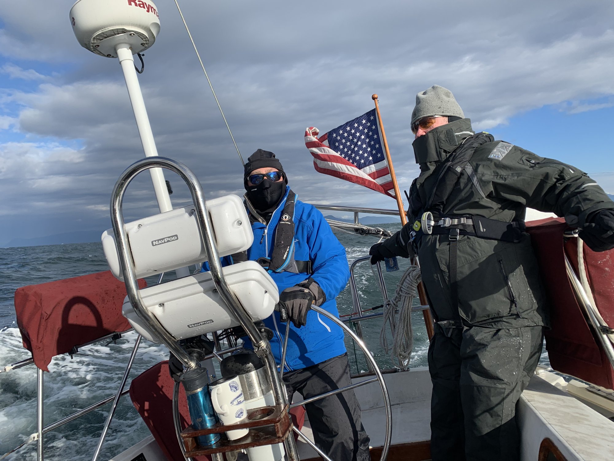
The Strait can be an exciting place. Aboard Mahalo a 36ft Catalina owned by @LeslieTroyer cruiscing from Vancouver BC to Annette Inlet BC
10 Feb 2019
Here is a good link to have for planning.
 mapcarta.com
Magnetic Compass and Nautical Chart Requirements
www.boat-ed.com
boat-ed.com
www.boat-ed.com
Canadian Coast Guard - Canada.ca
The Canadian Coast Guard is a special operating agency within the Department of National Defence. We work to ensure the safety of mariners in Canadian waters and protect Canada’s marine environment.
Charts and Nautical Publications Regulations, 1995
The Charts and Nautical Publications Regulations of the Canada Shipping Act require that the master and vessel owners carry the most recent editions of charts, publications and documents updated with the Monthly Edition of Notices to Mariners, published for the area in which the vessel is navigating.
- Charts (can be in electronic form)
- Catalogue of Nautical Charts and Related Publications (published by the Canadian Hydrographic Service)
- Annual edition of the Notices to Mariners (published by the Canadian Coast Guard)
- Sailing Directions (published by the Canadian Hydrographic Service)
- Tide and current tables (published by the Canadian Hydrographic Service)
- Lists of light, buoys and fog signals (published by the Canadian Coast Guard)
- The Radio Aids to Marine Navigation (published by the Canadian Coast Guard)
- Ice Navigation in Canadian Waters (published by the Canadian Coast Guard)
Canadian nautical charts and some publications are available from over 700 authorized Canadian Hydrographic Service Chart Dealers located across the country and internationally.
The Strait can be an exciting place. Aboard Mahalo a 36ft Catalina owned by @LeslieTroyer cruiscing from Vancouver BC to Annette Inlet BC
10 Feb 2019
Here is a good link to have for planning.
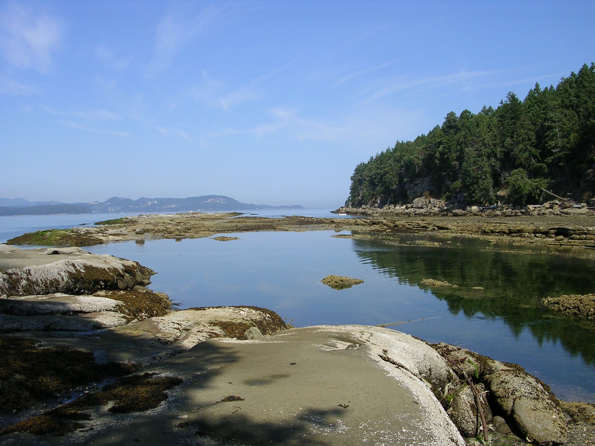
Gabriola Island
Gabriola Island is one of the Gulf Islands in the Strait of Georgia in British Columbia, Canada. Gabriola Island from Mapcarta, the free map.
That shot needs to go in the photo contest thread.Welcome to the site @Prairie Virgin Sailor .
Nothing special about radio, just monitor channel 16 as usual. If this is your first crossing of Georgia Straight, be sure to monitor the weather carefully. After all, this area isn't called the graveyard of the Pacific for nothing. On a clam day, we have seen stand up paddleboarders make the crossing (with a pilot boat). On a rough day, you don't quickly forget.
Also, you must have the pertinant CHS charts for the area as there are lots of crunchy bits near Nanaimo.
You're going to love it and a camera is mandatory.
View attachment 189967
jssailem
SBO Weather and Forecasting Forum Jim & John
- Oct 22, 2014
- 24,488
It is from 2019... I thought the photo contest thread required 2020 images.
In the spirit of fair play it does not seem right.
It is a fun shot to have appear on my computer. At the helm is @Ward H
It was his first time crossing the Strait. So decided he needed some open water experience. It was a sporty day and he learned the important lesson of keeping an eye on the next few coming waves and steering into the big ones to ride over them and help keep the boat upright.
Depending upon your route, Whiskey Golf Military Test Range may interfere with your crossing. Monitor VHF channel 16 for any announcements whether the test area is active and must be avoided. It is safe to cross if inactive. Announcements usually begin the day before and are repeated periodically.
Over the years we have crossed Georgia Strait many times and have had some of our best sailing experiences. The Admiral gripped so hard she left some dents in our SS helm guard tubing on one of our more spirited crossings. The crew (me) was ecstatic and took some great video clips while auto was busy keeping us on a steady course.
And then there have been times when she was flat and calm, but those are usually rare. West to east a good northwesterly will make for a nice close reach port tack. East to west, just the opposite. An article about Whiskey Golf is here: Whiskey Golf Military Test Range

As others have said going across the strait can be an eye opener for example on one trip from Van to Nanaimo we ran out of wind in the middle, but then it was lunch time so we lit the BBQ and had some lunch 1.5 hrs later we had 5-15 knots of wind another time reefed in head sail no main seas 6-8 feet 25-35 knots no lunch but great sail. Just note its 4-8 hrs to cross and in that time weather can change you also have tides and currents and even 2-4 ferries that are going to make the same crossing.
jssailem
SBO Weather and Forecasting Forum Jim & John
- Oct 22, 2014
- 24,488
Especially the Dinghy Dock Pub in Mark Bay on Wednesdays for the weekly sailboat race.some cool pubs on the island.

Stay alert, big ships move fast and can can close the sightline distance in a matter of minutes.
These things cruise at 18 kts. and always want to go exactly where you are.Stay alert, big ships move fast and can can close the sightline distance in a matter of minutes.

Indeed if you are on a NW tack nearing the East coast of Vancouver Island you may catch the SE corner of Whiskey Golf. During operational hours Winchelsea (Range) Control monitors and is very responsive on VHF CH 10. They will tell you if the range is active or if you are clear to transit WG. Canadian CG on 83A (in the US mode) will also give you this information.Depending upon your route, Whiskey Golf Military Test Range may interfere with your crossing. Monitor VHF channel 16 for any announcements whether the test area is active and must be avoided. It is safe to cross if inactive. Announcements usually begin the day before and are repeated periodically.
Commercial vessels in that area will be monitoring CH 11 and may but not necessarily monitor Ch 16. It will get a bit hairy as you close in on Nanaimo Harbour. You will have the BC ferries on the Departure Bay - Horseshoe Bay route to contend with (many times if you are tacking across their route). Also the Duke Pt - Tsawwassen ferries and Nanaimo - Gabriola ferry come into play if you enter the harbour from the South. Of course throw in Seaspan tugs, Harbour Air seaplanes and the normal multitude of recreational boaters and you will have earned your chosen libation at the end of your trip.Stay alert, big ships move fast and can can close the sightline distance in a matter of minutes.
Start asking/looking around for used charts. You should be able to find a good set as most folks in this digital era just want to get rid of them. As mentioned above new ones from CHS at $20 a pop can add up real fast.Excellent, thanks for the info. I have been using Navionics re charts however I would like to obtain paper charts as well. Is there a website where I can get paper charts? Is so, can you attach the URL link? Thanks
Last edited:
