Boats hit rocks all the time, often snapping off deep keels.

TomY

Alden Forum Moderator
Jun 22, 2004
2,758
Alden 38' Challenger yawl Rockport Harbor
It's refreshing when the captain gives an honest account of the accident. I know many people who are uneasy talking about a damaging grounding. Some will do their best to cover it up. Pride, I guess.

It's too bad because there is always much to learn from grounding accidents.

This blog written by a yacht design firm in Maine is a really good one. These guys design boats with Maine conditions in mind(they even talk about pot warp in underbody design!).

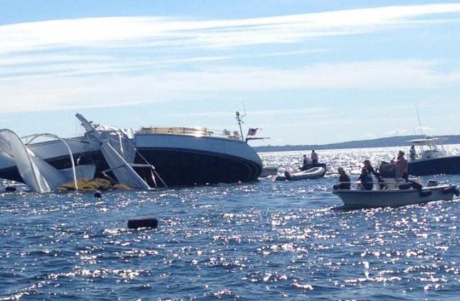
Usually when a deep keel boat hits a ledge - hard - there is massive damage to the hull.

Here's a case of a strike at high speed, where their keel to hull design held up quite well. Sure there was major damage but after a high speed ledge hit, keel to hull damage can be a lot worse!

As to the cause of the accident, I was glad to see the author list the primary cause as complacency. I so agree. You can try to massage your mistake in so many ways (we all will do that), but in the end, it's complacency.

The author hints that maybe he was a better navigator with charts alone(possible), but then he realizes,....

"Equipment is not to blame, inattention is. But, there are some valuable lessons here: First, GPS equipment only works when you look at it. Hoi An’s plotter is below at the chart table."

.... that a GPS, or chart, not in front of you, isn't doing anything as a navigation tool.

I don't know about #2, short handed. I find I'm a better navigator when I single hand. I'm easily distracted by those around me :). I've never sailed with a dedicated navigator anyway.

Here it is, grisly pics and all. I'd sail anywhere with this guy.


https://stephenswaring.com/a-rock-and-a-hard-place-lessons-learned-going-aground-in-hoi-an/
 
Nov 30, 2015
1,336
Hunter 1978 H30 Cherubini, Treman Marina, Ithaca, NY
Good read @TomY. That’s something I pray doesn’t happen to us. Not trying to stir the pot too much here but wouldn’t a reasonably keen observer and navigator such as the author professes to be, had realized two images (of premier interest) were upside down? :cool: Perhaps additional complacency or just blame the damn internet equipment?
 
Oct 24, 2010
2,405
Hunter 30 Everett, WA
As you say, just a distraction can do it. I hit a big rock a few years ago. It was on the chart. I'd been fishing waiting for slack current in Deception Pass. When I realized it was time to head through the pass, I stowed my rod and powered up. It looked fine, but the submerged rock didn't budge. I was approaching the pass from the South (normally always come in from the north.) Active Captain now has a hazard there. Fortunately for me, Damage was minimal which surprised me because I thought we hit awfully hard. A diver looked it over well so I left it in the water another year. When I pulled it out, I could confirm what the diver said. a scratch on my iron keel. nothing touched the fiberglass, prop, or rudder. I think I was lucky indeed.

Ken
 
Nov 8, 2010
11,386
Beneteau First 36.7 & 260 Minneapolis MN & Bayfield WI
We hit bedrock on Kestrel doing two knots at Isle Royale. While the damage was limited to a dent in the bulb on the lead keel, the force of the impact was atrocious. Your entire fixed world stops instantly, and anything not fixed hard to that world (like people) keeps moving. It was a mess. Several years ago a boat 'racing' in the Newport/Ensenada race motored straight into a rock wall on an island doing 7 knots. I can't image that collision.
 
Sep 15, 2013
707
Catalina 270 Baltimore
Yup. I hit rocks too. I had Mystic for all of a month and I cut too close to Fort McHenry and CRRRUNCH. I did not see the bottom previous to the grounding so I am not sure which of the dings in the keel and scrapes in the rudder were attributed to this. I am sure several were. We we absolutely stuck between several rocks. I swung out on the boom and tilted us out while the Admiral steered us out. We did not hit it dead on, more like scraping into an underwater rip rap embankment. We were lucky as I think the tide was rising as we were trying to figure out how to get free.
 
Sep 15, 2013
707
Catalina 270 Baltimore
It was all and all a lucky day. I was also very close to the seawall at the edge of Fort McHenry. Fortunately it was in 2013 during the government shutdown so there was no one around to yell at me.
 
Jan 11, 2014
11,321
Sabre 362 113 Fair Haven, NY
Fortunately it was in 2013 during the government shutdown so there was no one around to yell at me.
Maybe government shutdowns aren't so bad. :biggrin:

Having your keel become intimate with a large immovable object, say a rock or rock pile, will get your attention no matter what the speed. Just sayin'
 
  • Like
Likes: bawlmer

Gunni

.
Mar 16, 2010
5,937
Beneteau 411 Oceanis Annapolis
In the Chesapeake we like to say, ‘There’s them that’s been aground, and them that’s going aground’ but man, you really have to work at it to hit a rock in the Chesapeake!

A hard grounding is my absolute nightmare, I spend hours at chart study when we sail the thorny path and still I fret. In the early years we easily spent 75% of our sailing time confirming our location and reconfirming. First with LORAN and later with first gen GPS handhelds I filled my bookshelves with lists of lights and cruising guides, carefully entering the lat Lons for each and every rock, coral head and shoal in my cruising area. I set guard waypoints.... Our locating effort dropped to maybe 20% of the sailing day. I had more screen time than a teenager with a new iPhone. When the first of the helm mounted chart plotters came out I was an early adopter. I would not be without a GPS plotter at the helm. If I am on a strange boat I have a type of RAM mount for my handheld. There is still a chart on the seat, but there is always a chartplotter at eye level.
 
Oct 1, 2007
1,856
Boston Whaler Super Sport Pt. Judith
In the Chesapeake we like to say, ‘There’s them that’s been aground, and them that’s going aground’ but man, you really have to work at it to hit a rock in the Chesapeake!

A hard grounding is my absolute nightmare, I spend hours at chart study when we sail the thorny path and still I fret. In the early years we easily spent 75% of our sailing time confirming our location and reconfirming. First with LORAN and later with first gen GPS handhelds I filled my bookshelves with lists of lights and cruising guides, carefully entering the lat Lons for each and every rock, coral head and shoal in my cruising area. I set guard waypoints.... Our locating effort dropped to maybe 20% of the sailing day. I had more screen time than a teenager with a new iPhone. When the first of the helm mounted chart plotters came out I was an early adopter. I would not be without a GPS plotter at the helm. If I am on a strange boat I have a type of RAM mount for my handheld. There is still a chart on the seat, but there is always a chartplotter at eye level.
+1. We sail with our two dogs aboard and I pay very careful attention to our position. Having sailed in Maine back when we had Loran and radar, I learned to never lose concentration. It was so easy back then to get yourself in a position where you look ahead and say to yourself "...hmmm I didn't expect to see an island ahead just now..."
 

DArcy

.
Feb 11, 2017
1,690
Islander Freeport 36 Ottawa
Loran was a step up from DR but not a big step. Maybe it was just the Texas Instruments unit I used but it was horrible at lat/long conversion. I mostly plotted TDs on the chart. Switching to GPS was a big step, even the early handhelds.
I hit a rock the first season I had my boat. I knew it was there, I just didn't know quite where I was. Skip forward about 18 years to 2016, I was on a race with a guy that knows this water as well as anyone. It was dark and I was trusting the skipper and this very experienced guy to know where we were which turned out to be a mistake; I was just saying we were in too far and we hit that same rock. Some people just don't learn :oops:. Both times were glancing so no real damage.
 
Jun 23, 2013
271
Beneteau 373 Newport
Another thing to throw into the mix. Although gps can show where you are re lat long within a few feet, the chart beneath it was probably drawn before even loran. So the position of that rock or land mass as shown on the chart may be off by ????
Mark 1 eyeball and little extra distance or depth can save the keel.
 
Oct 22, 2014
20,989
CAL 35 Cruiser #21 moored EVERETT WA
You sail in the Chesapeake and even with a shoal draft boat you can run aground miles from shore. The sand and silt just moves about. Saying near the deeep channel markers, at least in the south end, is just good sense.

Here in the Pacific NW you can sail in deep water, but even here you can be fooled. Skagitt Bay is one area. You sail along the west end and you find a channel 60 plus feet deep and about .5 to 1 mile wide. You look out to the east and there is 3 plus miles of water to the shore line. It is 4 and less feet deep. Drifting into that beautiful water can quickly spoil your day.

Add to this deep water are the occasional ROCK that appears on the charts and hides 2 feet beneath the waters. They have disguised names like: Seal Rks, Lawsons Reef, Johnstone Reef and Black Rk... to name a few. So if you are the type that sets your route and then lets the machine do the work. You might discover one of these gems up close and personal.
 
Oct 19, 2017
7,732
O'Day 19 Littleton, NH
.... that a GPS, or chart, not in front of you, isn't doing anything as a navigation tool.
I hit a rock the first season I had my boat. I knew it was there, I just didn't know quite where I was.
Isn't that always the way!?!
Mark 1 eyeball and little extra distance or depth can save the keel.
My wife and I set sail in Key West, on my hobie 18, to go snorkeling on the reef. We get out there and see mooring balls to tie to. Easing around to come up on one, I was watching it, trying to judge my speed and angle to the winds for a good approach to pick it up. Doing only a knot or so, I spotted the painter trailing out and turned toward it when WHAM! I hit a reef head coming nearly to the surface between me and that ball. It caught the dagger board and my wife went sprawling across the trampoline. I couldn't help imagining being on a bigger, heavier boat and doing that. We suffered no discernable damage, but wow! Stop looking at the water and that's what you get. I, of course, didn't have any electronics on board. It was circa 1989. We had a chart but no compass.

The only time I've ever been lost in the woods up here was the one time I pulled out my compass. I had studied the USGS map before parking my truck under some powerlines that crossed over a mountain range that ran north south. I then followed the ridge on the northern side of the line for several hours. Deciding it was time to head back, I turned to retrace my steps and decided that I could save time by simply heading directly South, pick up the powerline and walk the open cut back to my truck. I used my compass and turned South and walked and walked. Eventually, I realized I had no idea where I was and I'd been walking a lot longer out than in. I came across a stream and followed it down hill to the road that ran along the foot of the mountain I was parked on top of. It was still a long ways back. Returning home, I studied the map again. While the range did run mostly North South, at the point where the power lines crossed, it took a nearly 90 degree jog to run East West and the powerlines ran North South. I was walking perpendicular to the powerlines because I hadn't paid close enough attention to my map when looking at the area while planning.

I disagree that Loran is only a small step up from DR. All the fishing captains use to keep their Loran reading top secret for their favorite fishing spots. DR would never find those spots consistently when you are 40 to 80 miles off shore.

I've done some amazing DR navigation in the fog around Vinelhaven, but I feel dumb luck seems to like my company too.:confused:

- Will (Dragonfly)
 
Jan 11, 2014
11,321
Sabre 362 113 Fair Haven, NY
I disagree that Loran is only a small step up from DR. All the fishing captains use to keep their Loran reading top secret for their favorite fishing spots. DR would never find those spots consistently when you are 40 to 80 miles off shore.
In the later days of LORAN and the early days of GPS, the big difference was that LORAN gave repeatably locations, i.e., if your Loran said you were at X spot you may really be at Y. But if you went back to X coordinates you would always be at X. GPS on the other hand was more accurate, but not repeatable. If you were trying to find X coordinate on a chart, the GPS would almost always get you closer than LORAN, but when you went back you might in a different spot, but still closer than LORAN. This was back in the day when the GPS signals were degraded for commercial and recreational use.

The reason fisherman liked LORAN is that it would also put them over the same spot, GPS wouldn't do that.
 

TomY

Alden Forum Moderator
Jun 22, 2004
2,758
Alden 38' Challenger yawl Rockport Harbor
I can't say for sure, but this accident may have happened on a locally well known hazard. But that's not too important as this hazard is all over our coast.

These are well charted but unmarked rocks that are casually passed when tides expose the granite tops. Surrounded by white water aprons seen from miles away. You'll go closer to see seals basking on the glistening rock shelves. They're beautiful.

But our wide tidal range presents two playing grounds.

At high water, many of these same stone monuments are invisible to best eyes. Far enough below as not to give any clue at all, that they are there.

The same area that was so nicely outlined at low tide, connected shorelines, beaches, protruding rocks, look completely different at high water. The distance to shore may double - triple, big islands have become small rocks just above the waterline, and rocks that 6 hours before were dry and covered in basking seals, are now 3 feet below the surface.

This set of rocks gets one or two boats, a year. They got me,...once.

 
  • Like
Likes: Will Gilmore
Oct 19, 2017
7,732
O'Day 19 Littleton, NH
This set of rocks gets one or two boats, a year. They got me,...once.
That's not Christmas, thank God! Is that a picture of your boat, Tom? I fell awful for anyone who's boat ends up like that.

- Will (Dragonfly)
 

TomY

Alden Forum Moderator
Jun 22, 2004
2,758
Alden 38' Challenger yawl Rockport Harbor
That's not Christmas, thank God! Is that a picture of your boat, Tom? I fell awful for anyone who's boat ends up like that.

- Will (Dragonfly)
No, that accident was infamous, especially on the forums. ARCHANGEL, a 70' yacht, manned by a professional captain/crew - who had been through this stretch of water many times - hit the ledge (4' or more submerged at high water) with such force, the carbon fiber rig snapped off the boat.

Short story: They had several CP GPS screens, on deck (2 I think) and below deck. But no one was looking at them at the time as they thought they knew where they were as they made a short simple run of about 6 NM, in familiar waters.

Last season, friends did the same thing. They hit so hard with a large wooden yawl, framing all through the hull was compromised from the impact. The damage was very extensive.

I hit the ledge nearly 20 years ago after work, taking my family across the bay, for an overnight. Pre GPS, I had a chart in my lap, a loran below, my "mark 5 eyeballs" doing the eyeball navigation on a fine beam reach.

We took a different toll. Slithering up and over the rocks(3' below water), our centerboard linkage bound up and launched the entire bronze centerboard trunk off the keel, and through the house top. We started going down immediately as we were back in deep water and the hole below the sole was,...large.

We had one option: Run the boat onto the nearest island, about 1 mile away. We made it just as the water, over the settees in the cabin, reached the air intake on the diesel. We saved the boat, refloated on the next tide, hauled out immediately and made repairs. Luckily, because I did the work myself, we came in just under the insurance c., totaling the boat.

We laugh about it now but I NEVER laugh at anyone else, that hits those rocks(any rocks).
 
  • Like
Likes: Will Gilmore