• Sailing is all about the Weather.

    Big into the exploration of Atlantic Hurricanes since Katrina came uninvited into his world, James (Jim) Gurley (JamesG161) has followed every Tropical Storm birthed in Atlantic, Gulf and Caribbean waters since. Being a boater, he knows that we often need more time to prepare than we get from the TV weather folk. Jim relies on the science of storm development to share early warning info with friends and fellow boaters.

    Early in 2018, Jim and John Shepard, (JSSailem) started to chat about the weather data available. John asked Jim to help forecast Pacific NW storms, and this morphed into discussions on weather forecasting.

    For John, sailing in the PNW is sometimes hit and miss. One day is ugly, then a string of beautiful days but no wind, followed by a series of blue-sky days and 12 knot breezes. Being ready for those great sailing days means you need to look to the Pacific Ocean and what is brewing. John has been into Pacific NW Weather since the 1970’s when his first PNW November storm hit bringing more than 40 days and 40 nights of continual rain.

    Together we want to share information, new APPs, safety, and thoughts about letting the weather help you. Identify some of the resources for sailors and help prepare you for your next sailboat outing.

    It is far better to go out on the water knowing what to expect in weather terms, than to be out on the water and see dark ominous clouds suddenly appear, unprepared.

2022 Atlantic Hurricane Season - Mid Season + Final

JamesG161

SBO Weather and Forecasting Forum Jim & John
Feb 14, 2014
7,468
Hunter 430 Waveland, MS
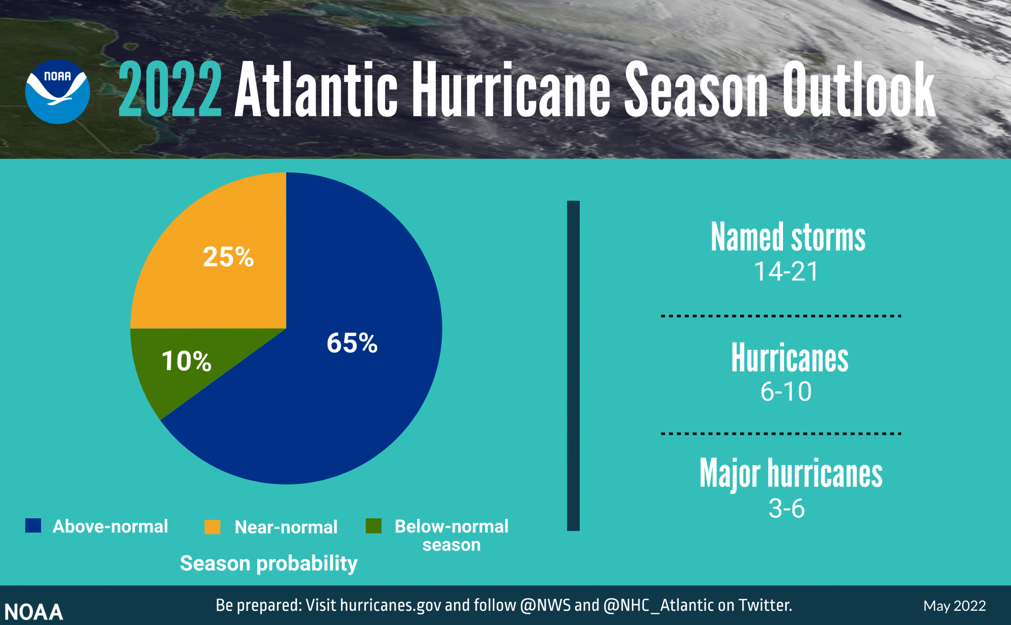
On May 24th the NHC released its 2022 forecast.

IMAGE-Hurricane-Outlook-May-2022-Pie-052422-NOAA.png


Their Names

IMAGE-Hurricane-Outlook-May-2022-Names-052422-NOAA.png


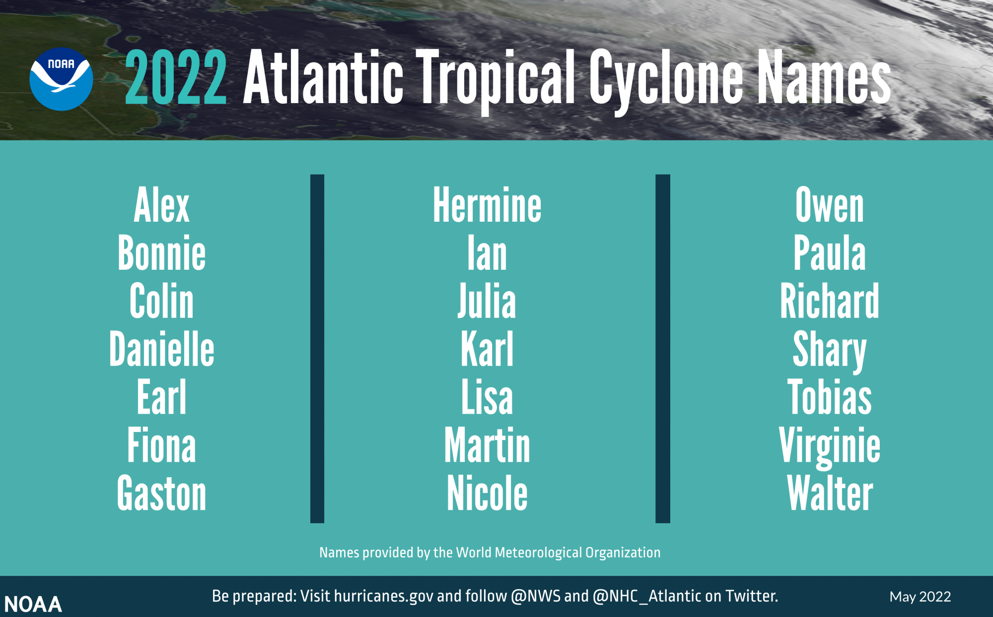
At least the "C" was not Clyde aka Bonnie & Clyde.:facepalm:

Basically it is the same as the 2021 Atlantic Hurricane Season.
In their words "Very Active"

The Forecast basis is the same, but they say the Tropical Atlantic is heating up faster now.

Main reasons for their STATISTICAL modeling for this Prediction.
1) Neutral ENSO [La Niña/El Niño] to good La Niña [Rain and Westerlies]
2) Strong African Monsoon season. [Source of the Atlantic Storms]
3) Weaker Trade Winds [Slower Trek across the Atlantic]
4) Higher than normal Sea Surface Temperatures [SST] in Tropical Atlantic and Caribbean.
____________
Some new Prediction and Monitoring Tools have been added this year.

Hurricane_Observation_Tech_v4_horiz_lores.png


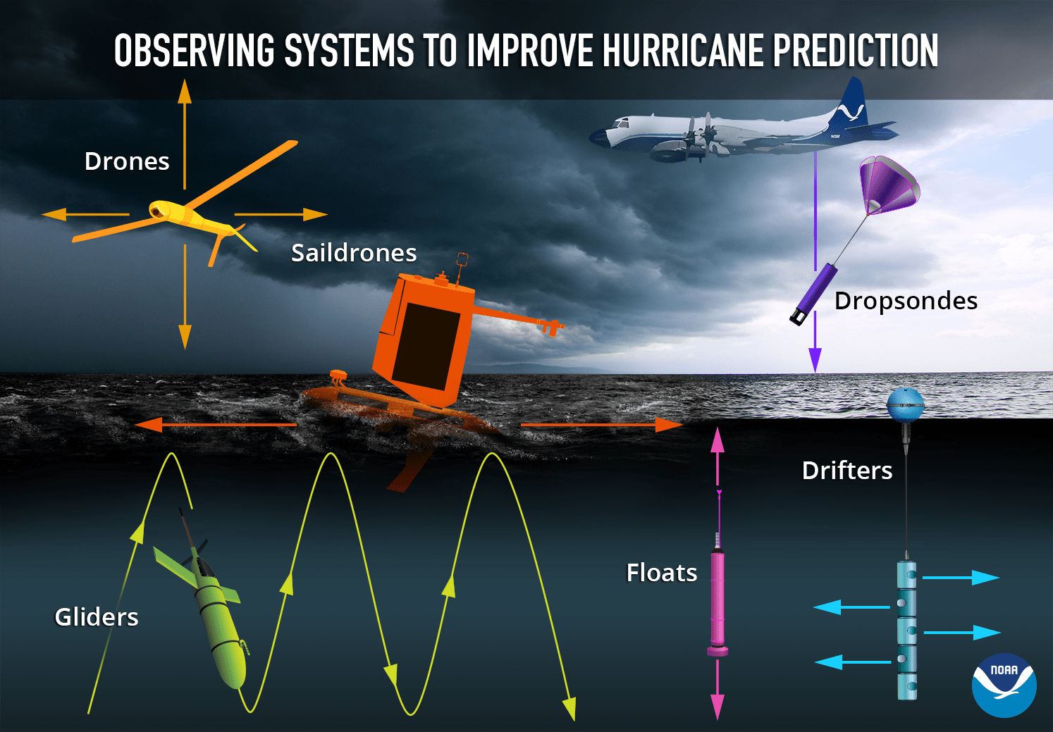
I like the ATLIUS DRONES that can fly at certain Altitudes , that the Hurricane Hunters can not fly.
ALTIUS Landing.jpg

The Glider
Glider_water_PR_2020.jpg
_____


Time is now for preparing your family and boat

Jim...
 
  • Helpful
Likes: jssailem

JamesG161

SBO Weather and Forecasting Forum Jim & John
Feb 14, 2014
7,468
Hunter 430 Waveland, MS
NOAA Downgraded this Season in August

Hurricane-Outlook-May-2022-Names-080422-NOAA.png


Hurricane-Outlook-May-2022-Pie-080422-NOAA.png


What do we expect?

Many Atlantic Fish Storms.
_________
Where are we extra vigilant?

Formations in and near the Caribbean

Why?

ohc_naQG3_ddc.gif


Tropical Atlantic is Low on HEAT fuel.
Jim...
 

JamesG161

SBO Weather and Forecasting Forum Jim & John
Feb 14, 2014
7,468
Hunter 430 Waveland, MS
Final Hurricane 2022 Season results.
H2022 final.gif


Please read what John and I showed and forecast above.

John and I are reviewing why NOAA missed their forecast.:facepalm:

Note: The 2023 forecast is Mid April.

Jim...
 
Jun 21, 2004
2,534
Beneteau 343 Slidell, LA
Note: The 2023 forecast is Mid April.
Read this AM that LaNina is petering out this spring to a neutral condition, after three years. El Nina condition will develop; however, unknown if it will be in place by active months of upcoming hurricane season. Sure hope so!
 
  • Like
Likes: JamesG161