Does the Vulcan GPS not give that information?The GPS puck adds a lot because it gives heading (compass), heel, and trim, and at 10 hz provides rate info. Whether the rate is fast enough for AP is something I don't know.
Wind instruments - B&G wireless vs. B&G wired vs. ????
- Thread starter Cederholm
- Start date
jssailem
SBO Weather and Forecasting Forum Jim & John
- Oct 22, 2014
- 24,454
It displays the information. The data is developed in the sensors. The puck provides the sensors.Does the Vulcan GPS not give that information?
Yes, but the Vulcan has a built-in GPS. Does the puck provide different data than the Vulcan GPS?It displays the information. The data is developed in the sensors. The puck provides the sensors.
The Vulcan only has a fairly basic built-in GPS so the more accurate puck GPS adding the compass and other features is very significant.Does the Vulcan GPS not give that information?
jssailem
SBO Weather and Forecasting Forum Jim & John
- Oct 22, 2014
- 24,454
Reading the N2K PG Ns specifications I do not see the a listing for heel or trim as a function of the Vulcan.
 www.bandg.com
Heel would require a sensor.
B&G identifies these as Add On's to your Vulcan.
The B&G ZG100 GPS antenna ( B&G ZG100 GPS & Compass | B&G Sailing USA ) provides precise and dependable position data making it the perfect partner for B&G chartplotters and instrument systems.
The integrated compass delivers accurate heading information for instruments, chart stabilisation for Head Up mode and Radar overlays. It also provides Heel and Trim data for sailing.
The Precision-9 Compass supplies accurate heading and rate-of-turn information to B&G autopilot, radar and navigation systems over an NMEA 2000® connection.
 www.bandg.com
Vulcan 7 | B&G Sailing USA
7-inch sailing chartplotter. Easy-to-use, touchscreen display with built in GPS, Wi-Fi and dedicated sailing features
Heel would require a sensor.
B&G identifies these as Add On's to your Vulcan.
The B&G ZG100 GPS antenna ( B&G ZG100 GPS & Compass | B&G Sailing USA ) provides precise and dependable position data making it the perfect partner for B&G chartplotters and instrument systems.
The integrated compass delivers accurate heading information for instruments, chart stabilisation for Head Up mode and Radar overlays. It also provides Heel and Trim data for sailing.
- I am guessing here that the trim data comes from an internal sensor and is communicated to your Vulcan through the NMEA 2000 data transfer. It looks like the "Attitude" data string would be providing the TRIM data
| NMEA 2000® PGNs | |
| PGN Number PGN Title | |
| 126992 System time | |
| 129025 Position, Rapid update | |
| 129026 COG & SOG RU | |
| 129029 Position data | |
| 129539 GNS DOP | |
| 129540 GNS Satellites in view | |
| 127258 Magnetic variation | |
| 127250 Compass heading (Vessel heading) | |
| 127251 Rate of turn | |
| 127257 Attitude | |
The Precision-9 Compass supplies accurate heading and rate-of-turn information to B&G autopilot, radar and navigation systems over an NMEA 2000® connection.
Precision-9 Compass
The Precision-9 Compass supplies accurate heading and rate-of-turn information, based on an internal array of solid-state sensors that measure motion and orientation on nine axes.
Super helpful! Thanks for taking the time to post.Reading the N2K PG Ns specifications I do not see the a listing for heel or trim as a function of the Vulcan.
Vulcan 7 | B&G Sailing USA
7-inch sailing chartplotter. Easy-to-use, touchscreen display with built in GPS, Wi-Fi and dedicated sailing features
Heel would require a sensor.
B&G identifies these as Add On's to your Vulcan.
The B&G ZG100 GPS antenna ( B&G ZG100 GPS & Compass | B&G Sailing USA ) provides precise and dependable position data making it the perfect partner for B&G chartplotters and instrument systems.
The integrated compass delivers accurate heading information for instruments, chart stabilisation for Head Up mode and Radar overlays. It also provides Heel and Trim data for sailing.
- I am guessing here that the trim data comes from an internal sensor and is communicated to your Vulcan through the NMEA 2000 data transfer. It looks like the "Attitude" data string would be providing the TRIM data
NMEA 2000® PGNs PGN Number PGN Title 126992 System time 129025 Position, Rapid update 129026 COG & SOG RU 129029 Position data 129539 GNS DOP 129540 GNS Satellites in view 127258 Magnetic variation 127250 Compass heading (Vessel heading) 127251 Rate of turn 127257 Attitude
The Precision-9 Compass supplies accurate heading and rate-of-turn information to B&G autopilot, radar and navigation systems over an NMEA 2000® connection.
Precision-9 Compass
The Precision-9 Compass supplies accurate heading and rate-of-turn information, based on an internal array of solid-state sensors that measure motion and orientation on nine axes.
Let's back up a step. If an AP is on the wish list the choices are pretty limited for wheel pilots, either Raymarine or CPT. A below decks AP is also a possibility, however, the cost of installing a below decks AP is pretty high, haven't priced on in a few years, but expect around $3000.
Look at the data requirements for those 2 APs. They may not need the additional data provided by a heading sensor like the Precision 9 or the B&G GPS.
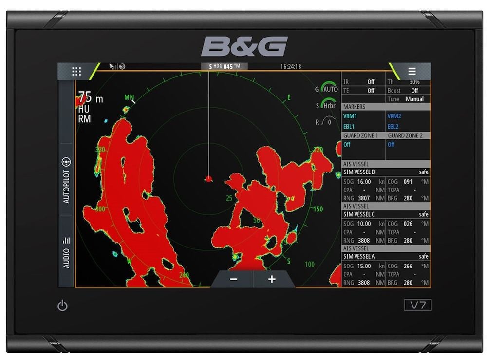
Also consider whether you plan to add radar. In order to overlay radar on charts and to have accurate tracking of radar targets, you will need highly accurate position data such as provided by the Precision 9 and may not be provided by the GPS unit.
If you haven't done so already, map out your electronics needs and want. Develop an implementation schedule, i.e., what's most important and when you will need it. This will help have all the pieces fall into place and make decisions easier.
Look at the data requirements for those 2 APs. They may not need the additional data provided by a heading sensor like the Precision 9 or the B&G GPS.
Also consider whether you plan to add radar. In order to overlay radar on charts and to have accurate tracking of radar targets, you will need highly accurate position data such as provided by the Precision 9 and may not be provided by the GPS unit.
If you haven't done so already, map out your electronics needs and want. Develop an implementation schedule, i.e., what's most important and when you will need it. This will help have all the pieces fall into place and make decisions easier.
Great advice. Since I'm running a tiller my options are even move limited. I'll investigate.Let's back up a step. If an AP is on the wish list the choices are pretty limited for wheel pilots, either Raymarine or CPT. A below decks AP is also a possibility, however, the cost of installing a below decks AP is pretty high, haven't priced on in a few years, but expect around $3000.
Look at the data requirements for those 2 APs. They may not need the additional data provided by a heading sensor like the Precision 9 or the B&G GPS.
Also consider whether you plan to add radar. In order to overlay radar on charts and to have accurate tracking of radar targets, you will need highly accurate position data such as provided by the Precision 9 and may not be provided by the GPS unit.
If you haven't done so already, map out your electronics needs and want. Develop an implementation schedule, i.e., what's most important and when you will need it. This will help have all the pieces fall into place and make decisions easier.
As far as the wish list, it's pretty much outlined above. No plans for radar, everything else but helm control to be added now.
The decisions get easier. Simrad, a sister company to B&G makes tiller pilots. Integration will be easier and probably less expensive. It does not appear the the external GPS is necessary. The unit is self-contained with a built in fluxgate compass, with the ability to use a more accurate external compass if available.Great advice. Since I'm running a tiller my options are even move limited. I'll investigate.
B&G has a package similar to the one you picked out with a display instead of the GPS. That might be a better choice for you. An extra display is handy. Make sure the Vulcan has a Simnet port.
Looks like the Vulcan only has NMEA 2000 and NMEA 0183 over wifi - what ever that means.The decisions get easier. Simrad, a sister company to B&G makes tiller pilots. Integration will be easier and probably less expensive. It does not appear the the external GPS is necessary. The unit is self-contained with a built in fluxgate compass, with the ability to use a more accurate external compass if available.
B&G has a package similar to the one you picked out with a display instead of the GPS. That might be a better choice for you. An extra display is handy. Make sure the Vulcan has a Simnet port.
man this stuff is confusing.
Quick and dirty lesson on Networking. There are 3 standards, NMEA 0183, NMEA 2000, and a NMEA Ethernet (not sure what they are calling it). 0183 is really ancient technology from the 1980s, way out of favor. The various manufacturers had their own names for it and proprietary plugs. NMEA 2000 is young, only 20+ years old there is greater compatibility between devices, still some manufacturers had proprietary plugs. And the new Ethernet standard.
Old NMEA 0183 devices can be connected to N2K (shorthand for NMEA 2000) devices with an adapter. Simrad sells such an adapter (see link). When you install your devices you will set up an N2K network, really pretty simple mostly plug and play. Connected to the network will be your speed/depth/temp transducer and the wind sensor. The network will then connect to a display device and can connect to a chartplotter. Turn everything on and they will all talk to each other and the data will be displayed on the Chartplotter and instrument display. You're in business. You can of course make this more complicated by adding more devices, on my network there are 3 tank sensors, AIS, precision compass, rudder angle, barometer, data recorder, wind, and s/d/t sensor. At this point you don't need all of this, except perhaps for AIS.
The Simrad TillerPilot will connect to the N2K network through the adapter. The adapter plugs into the network at a T and takes the data from the network to steer the boat. For the most part the internal compass on the tiller pilot will suffice when motoring along. When sailing, it is much more efficient to use the steer to wind mode, it is also more comfortable sailing as the AP is not fighting with the wind which will happen when it is gusty or shifty.
At this point, I don't think there is any need for a separate GPS antenna if you have a CP. Get the package with the display for the same money, the display will be more valuable than the GPS antenna. If you need it in the future, add the GPS.

 www.simrad-yachting.com
Old NMEA 0183 devices can be connected to N2K (shorthand for NMEA 2000) devices with an adapter. Simrad sells such an adapter (see link). When you install your devices you will set up an N2K network, really pretty simple mostly plug and play. Connected to the network will be your speed/depth/temp transducer and the wind sensor. The network will then connect to a display device and can connect to a chartplotter. Turn everything on and they will all talk to each other and the data will be displayed on the Chartplotter and instrument display. You're in business. You can of course make this more complicated by adding more devices, on my network there are 3 tank sensors, AIS, precision compass, rudder angle, barometer, data recorder, wind, and s/d/t sensor. At this point you don't need all of this, except perhaps for AIS.
The Simrad TillerPilot will connect to the N2K network through the adapter. The adapter plugs into the network at a T and takes the data from the network to steer the boat. For the most part the internal compass on the tiller pilot will suffice when motoring along. When sailing, it is much more efficient to use the steer to wind mode, it is also more comfortable sailing as the AP is not fighting with the wind which will happen when it is gusty or shifty.
At this point, I don't think there is any need for a separate GPS antenna if you have a CP. Get the package with the display for the same money, the display will be more valuable than the GPS antenna. If you need it in the future, add the GPS.
SimNet to NMEA 2000 Adaptor Kit
Connect a SimNet device with a fixed SimNet cable to a NMEA 2000® network
This is GOLD! Thank you for the clear explanation.Quick and dirty lesson on Networking. There are 3 standards, NMEA 0183, NMEA 2000, and a NMEA Ethernet (not sure what they are calling it). 0183 is really ancient technology from the 1980s, way out of favor. The various manufacturers had their own names for it and proprietary plugs. NMEA 2000 is young, only 20+ years old there is greater compatibility between devices, still some manufacturers had proprietary plugs. And the new Ethernet standard.
Old NMEA 0183 devices can be connected to N2K (shorthand for NMEA 2000) devices with an adapter. Simrad sells such an adapter (see link). When you install your devices you will set up an N2K network, really pretty simple mostly plug and play. Connected to the network will be your speed/depth/temp transducer and the wind sensor. The network will then connect to a display device and can connect to a chartplotter. Turn everything on and they will all talk to each other and the data will be displayed on the Chartplotter and instrument display. You're in business. You can of course make this more complicated by adding more devices, on my network there are 3 tank sensors, AIS, precision compass, rudder angle, barometer, data recorder, wind, and s/d/t sensor. At this point you don't need all of this, except perhaps for AIS.
The Simrad TillerPilot will connect to the N2K network through the adapter. The adapter plugs into the network at a T and takes the data from the network to steer the boat. For the most part the internal compass on the tiller pilot will suffice when motoring along. When sailing, it is much more efficient to use the steer to wind mode, it is also more comfortable sailing as the AP is not fighting with the wind which will happen when it is gusty or shifty.
At this point, I don't think there is any need for a separate GPS antenna if you have a CP. Get the package with the display for the same money, the display will be more valuable than the GPS antenna. If you need it in the future, add the GPS.
SimNet to NMEA 2000 Adaptor Kit
Connect a SimNet device with a fixed SimNet cable to a NMEA 2000® network
Carl
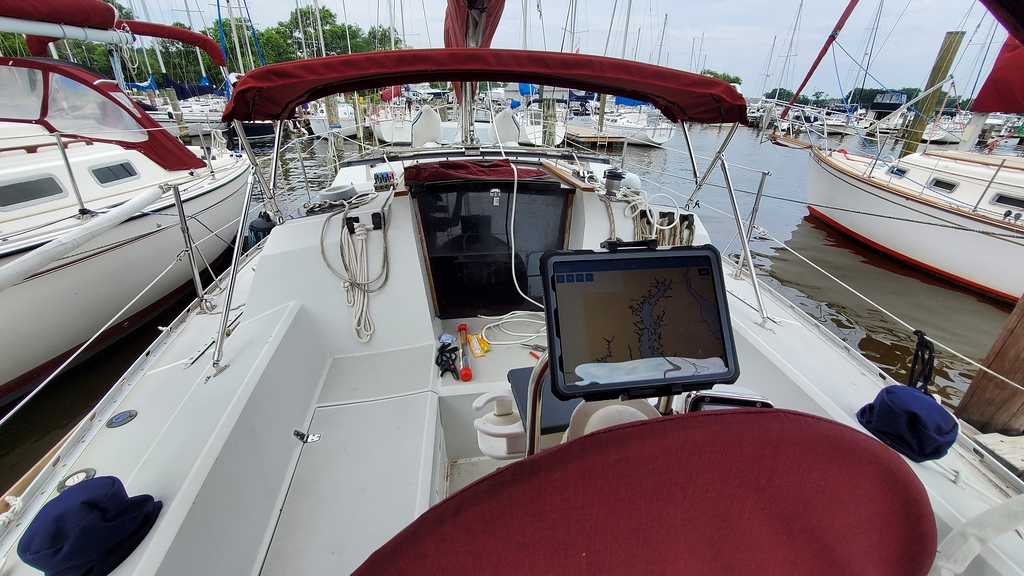
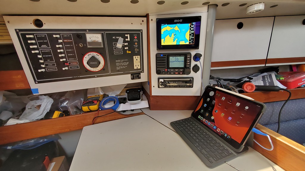
Beautiful setup!My Vulcan is at the nav station where it stays safe and dry. All functions easily mirror to an iPad at the helm. Mine is always in shade from a bimini and usually in a waterproof case. Simply takes a USB outlet at the helm.
Does anyone just feel the wind, watch the water, look for navigation aids, and sail anymore????Quick and dirty lesson on Networking. There are 3 standards, NMEA 0183, NMEA 2000, and a NMEA Ethernet (not sure what they are calling it). 0183 is really ancient technology from the 1980s, way out of favor. The various manufacturers had their own names for it and proprietary plugs. NMEA 2000 is young, only 20+ years old there is greater compatibility between devices, still some manufacturers had proprietary plugs. And the new Ethernet standard.
Old NMEA 0183 devices can be connected to N2K (shorthand for NMEA 2000) devices with an adapter. Simrad sells such an adapter (see link). When you install your devices you will set up an N2K network, really pretty simple mostly plug and play. Connected to the network will be your speed/depth/temp transducer and the wind sensor. The network will then connect to a display device and can connect to a chartplotter. Turn everything on and they will all talk to each other and the data will be displayed on the Chartplotter and instrument display. You're in business. You can of course make this more complicated by adding more devices, on my network there are 3 tank sensors, AIS, precision compass, rudder angle, barometer, data recorder, wind, and s/d/t sensor. At this point you don't need all of this, except perhaps for AIS.
The Simrad TillerPilot will connect to the N2K network through the adapter. The adapter plugs into the network at a T and takes the data from the network to steer the boat. For the most part the internal compass on the tiller pilot will suffice when motoring along. When sailing, it is much more efficient to use the steer to wind mode, it is also more comfortable sailing as the AP is not fighting with the wind which will happen when it is gusty or shifty.
At this point, I don't think there is any need for a separate GPS antenna if you have a CP. Get the package with the display for the same money, the display will be more valuable than the GPS antenna. If you need it in the future, add the GPS.
SimNet to NMEA 2000 Adaptor Kit
Connect a SimNet device with a fixed SimNet cable to a NMEA 2000® network
dj
Try as I might I couldn't get the AP to just feel the wind. It was looking for bits and bytes.Does anyone just feel the wind, watch the water, look for navigation aids, and sail anymore????
dj
")

Hahahaha - You need to train your autopilot better....Try as I might I couldn't get the AP to just feel the wind. It was looking for bits and bytes.
I guess I'm just used to simple autopilots where you just set a direction and they steer in that direction. If you want to go X degrees to one direction or another you just tell it to change the heading.
dj
More seriously, I sailed for many years with a windex at the top of the mast and feeling the breeze, I still do. But with a dodger, bimini and all kinds of stuff slowing and blocking the wind it can be a challenge to keep track of the wind, especially when you can't see the top of the mast.Hahahaha - You need to train your autopilot better....
I guess I'm just used to simple autopilots where you just set a direction and they steer in that direction. If you want to go X degrees to one direction or another you just tell it to change the heading.
dj
At least on the Zeus3s chart plotter there is a feature that tracks wind speed and wind direction. The Chartplotter's memory is much better than mine, the data helps to make decisions about course and tacking when passage making. It can also foretell weather changes as it tracks the wind shifts.
When just out sailing for the pure fun of sailing, I don't pay much attention to the wind instruments, especially after they were ripped from my masthead by an aggressive tree on the Dismal Swamp Canal.

Yup, I often borrow a Mercury from the club, no instruments, no motor, nothing but sail and tiller. Speaking of tiller I’ve even removed the wheel on my boat in favor of a tiller because I prefer the feel of it. That said I’ve never had these toys before and I want a few. Auto pilot mostly for single handing.Does anyone just feel the wind, watch the water, look for navigation aids, and sail anymore????
dj
I reflect on the Polynesian sailors that use no instruments at all. And I compare to our western movement to ever increasing reliance on technology.More seriously, I sailed for many years with a windex at the top of the mast and feeling the breeze, I still do. But with a dodger, bimini and all kinds of stuff slowing and blocking the wind it can be a challenge to keep track of the wind, especially when you can't see the top of the mast.
At least on the Zeus3s chart plotter there is a feature that tracks wind speed and wind direction. The Chartplotter's memory is much better than mine, the data helps to make decisions about course and tacking when passage making. It can also foretell weather changes as it tracks the wind shifts.
When just out sailing for the pure fun of sailing, I don't pay much attention to the wind instruments, especially after they were ripped from my masthead by an aggressive tree on the Dismal Swamp Canal.
I sailed for many years only watching the sails and feeling the wind, waves and how the boat felt. Many years later I put a windex on my mast head as I was told it was "needed". Honestly, once I got use to it I did find it helped me when I was pointing very high to the wind. But otherwise I didn't find it particularly useful.
I've still not gone to a chartplotter. Can't imagine I ever will. Now that being said, I very well my go to a tablet - pretty much the same thing. I do use a lap top with OpenCPN for route planning. I find that very useful. In fact, almost indispensable.
I find this comment very interesting: "The Chartplotter's memory is much better than mine, the data helps to make decisions about course and tacking when passage making. It can also foretell weather changes as it tracks the wind shifts." I'm going to have to think about this one a fair bit. Let me ask, do you find the decisions about course and tacking to be more useful close to land or when sailing into or around islands? I'm not sure I'm understanding how this helps for off-shore passage making. Your thoughts?
I will always just love sailing with nothing more than a boat, sails, and my ears, eyes, and brain....
dj