Full disclosure my name is Jason. You may recall the name "Mike Honcho" from the movie Talladega Nights. I use it in forums
Sailing in the Puget Sound
- Thread starter Bill Roosa
- Start date
thanks to all youall. Clearly a very friendly sailing community exists in the PNW also. I'll be settling in and have to buy a house/land-build and then get the retirement business restarted so I may be a while before the wife and I get around to sailing again.
Going through Deception when running 7kts? With or against? More guts than me...I was apprehensive about going thru some of the “scary” passages despite going thru wires ones. As a kid - so went miles out of my way to avoid deception pass or La Conner. @jssailem cured me of that when we did a sail together and went thru deception when it was runnin 7+ kts. No problems. Same with La Conner and the “ditch” easy once you’ve done it or go thru with someone who has.
In your area around Tacoma the Narrows can move the water, but it’s really wide so no sweat. Agate pass mentioned above is narrower but just watch the current (DeepZoom.com or a current atlas). I’ve sat off point Wilson doing all I’ve 1.5 SOG for what seems like hours - but that is not common if watching the current.
Planning trips is more complicated. @jssailem uses Costal Explorer (Navigator??) from Rosepoint as you can set current locations for various legs of the trip. Most common nav apps ignore current
Les
I’d never make it thru if against. Actually quite tame. Hit the uplifts in the middle and leave the camera & phone alone
jssailem
SBO Weather and Forecasting Forum Jim & John
- Oct 22, 2014
- 24,453
Here you go. A picture of the skipper in full control.

Zooming through the Passage
Zooming through the Passage
Hi Bill, welcome to the PNW where the sailing season lasts but a week, gunk holing locations forget it and currents always running against you. Plus never any wind, always rains, never any sunshine, etc., etc., etc. That is the PNW narrative we use for newcomers.How long is the sailing season, are there a lot of gunkholing destinations, do th strong currents cause scheduling issues

On a brighter note, the moderate climate allows us to cruise year around. A diesel furnace adds to the comfort for those off season cruises. A Waggoners Guide offers numerous gunk holing suggestions to numerous to mention here. Depending upon your chosen route, it helps to pay attention to tidal action and currents. Some passes should be transited at slack water. Generally, north south currents will run stronger than east west currents around the islands due to the sea water rush from/to the Strait of Juan de Fuca.
Ports and Passes and a good chart plotter helps us make time on the water almost trouble free and quite pleasant.
That was a low tidal day. the lowest low I have seen in Oak Harbor was -4.2' and the highest high was over +13'.Bill. Here is an atypical anchorage off the south coast of Lopez Island. Depths are in fathoms.
View attachment 151714
And a tidal report for a nearby location.
View attachment 151715
It is said sailing in the waters of the Puget Sound makes sailors. You’ll get to exercise all your navigational skills.
The reviews for AC in the app store are not good. Last time I looked at it (before Garmin took it over), it seemed pretty East Coast centric
As one who goes through Deception Pass several times on every cruise I almost never try to time the slack. It can and often is up to 45 minutes off due to wind influences. I time it to go in my direction which means I can go through 12 out of 24 hours whereas slack is only about 10 minutes long four times a day If you miss slack going to an adverse current you are stuck for 6 hours.Going through Deception when running 7kts? With or against? More guts than me...
The secrete to safe passage is to always stay in the north half of the main channel. I divide the channel into 1/3rds and place my boat in the northern 1/3rd line. The current on this side pushes you away from the Pass Island and flushes you straight through. If you go south of mid channel you WILL get into whirlpools which WILL turn you 90º toward Whidbey Island. North is safe, South is SCARY! I limit myself to 7 knots outbound and 6 knots inbound but those currents are only experienced for a couple of hours on high tide days so they are easy to wait out.
I used to teach a class on DP passages to my sailing club so If anyone wants more information, send me a PM.
Terry, as someone mentioned, AC is very east coast-centric. I looked at it back in SF and it was useless, unpopulated as it were. Before you bother with it on your phone, why not try it on your computer and see if there's anything worthwhile. I haven't since I've been here, since I've gotten more info from my new "real" friends here than anything I could get from AC. In fact, I haven't even looked, I trust them more! Good luck. Let us know what you find. I may even give it a go soon...Any other source besides Google?
I just did. What a waste. Not much of anything for comments that aren't better covered by Waggoners. At least in Canada.I may even give it a go soon...
Besides, as I've read on other forums, primarily cruisersforum, once Garmin took over, they messed up the graphics big time. Old days the chart took up 90% of the screen. Now it's only on the right side. I didn't find an easy way to get rid of the panes on the left. Might be there, but if it isn't easy to see how to do it...??? Plus it doesn't include the Canadian charts. Doh!
jssailem
SBO Weather and Forecasting Forum Jim & John
- Oct 22, 2014
- 24,453
Stu... you are morphing into a Canadian... "No Canadian Charts!' "Not much of anything... Canada" I'll bet you have given up baseball and are watching Hockey... Who would have thought it would be so easy to co-opt you.
Just uploaded the update to Coastal Explorer. There are charts produced by the "Canadian Hydrographic Service" approved by the Queen and in French for those so inclined "le Service hydrographique du Canada".
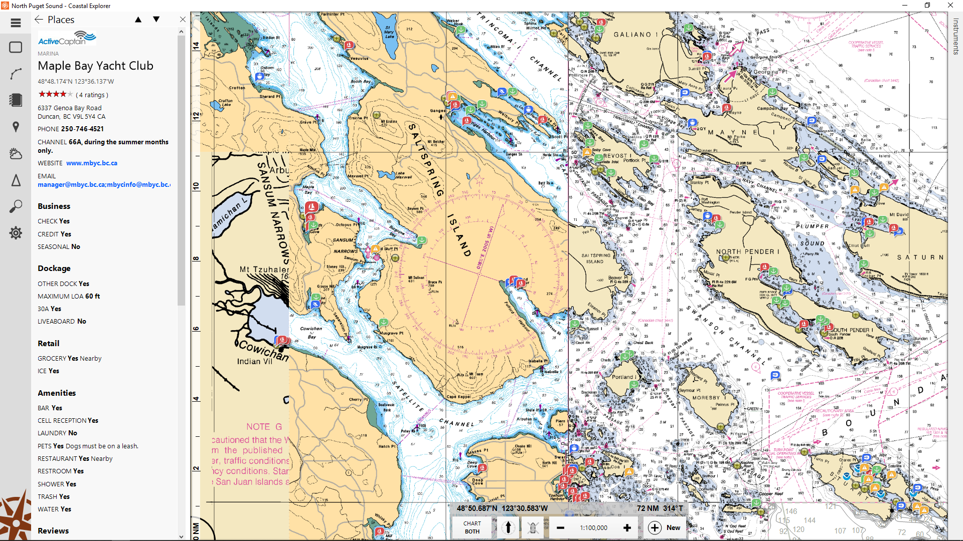
There are Active Captain identifiers with descriptions of places. The weakness is there are only a few skippers posting about the sites in the Pacific NW do reviews can be several years old. Here is a screen print of Maple Bay Yacht Club. 48* 48.174'N 123*36.137'W All of the place markers on the chart are AC references in Coastal Explorer. CE is using the new AC API.
Waggoner's has positioned themselves as the bible here in the PacficNW. They actively cruise the waters and contact the local haunts printing their annual Guide and updating their website with information.
"No Canadian Charts!' "Not much of anything... Canada" I'll bet you have given up baseball and are watching Hockey... Who would have thought it would be so easy to co-opt you. Just uploaded the update to Coastal Explorer. There are charts produced by the "Canadian Hydrographic Service" approved by the Queen and in French for those so inclined "le Service hydrographique du Canada".
There are Active Captain identifiers with descriptions of places. The weakness is there are only a few skippers posting about the sites in the Pacific NW do reviews can be several years old. Here is a screen print of Maple Bay Yacht Club. 48* 48.174'N 123*36.137'W All of the place markers on the chart are AC references in Coastal Explorer. CE is using the new AC API.
Waggoner's has positioned themselves as the bible here in the PacficNW. They actively cruise the waters and contact the local haunts printing their annual Guide and updating their website with information.
Those don't look like Canadian Charts John. Stu now needs the depths in metres!"No Canadian Charts!' "