I have been using an Tidal Currents trip planner for a few years. It's an app where you plug in your route, date and boat speed and it computes the best departure time based on the tides. It's great for long cruises, especially in parts of the eastern Long Island sound where the tidal currents can be pretty strong. It looks like it has stopped working and is no longer available for download. Does anyone know what happened to them or of a good replacement.
Tidal Currents Trip planner App
- Thread starter TimFromLI
- Start date
Aquamaps has pretty current and tide reporting on their app, however it does not do automatic route timing.
Although I've had little experience with tides and currents, not much of them on Lake Ontario, when I was in tidal water, I didn't find the planning all that difficult. I just looked for the most important area to watch for current and worked backwards. It worked pretty well on our trip a couple of years ago. We were able to take advantage of the currents in the Race and through the East River using Eldridge as our guide.
Although I've had little experience with tides and currents, not much of them on Lake Ontario, when I was in tidal water, I didn't find the planning all that difficult. I just looked for the most important area to watch for current and worked backwards. It worked pretty well on our trip a couple of years ago. We were able to take advantage of the currents in the Race and through the East River using Eldridge as our guide.

jssailem
SBO Weather and Forecasting Forum Jim & John
- Oct 22, 2014
- 24,464
We have a lot of issues with tidal currents here in The Salish Sea. Automatic systems are a risky.
I use Coastal Explorer (a PC based software). I compare with DeepZoom.com the route can adjust the departure and see the affect without having to calculate the details using a tidal chart.
OPENCPN is a free software that shows the affects of the tide on your route.based on a timeline that you identify.
Thanks for the replies the best thing about the app is that it can tell you what helps more, 6 hours of a one knot push or 2 hours of a 3 knot push. and all the combinations in between. some of our trips are 10 hours so it's nice if you can optimize the trip. Tidal currents trip planner was very accurate, if you put in enough waypoints.
I really need a tool like this for a trip I'm planning for a group this year that's got a 75-mile leg with up to 2.6kts of current. Would really like to be able to play with the departure time and have the route auto-update with the arrival time based on the currents during the day. We really don't want to arrive after dark. I built a spreadsheet to do this, but it's only able approximate. And it's pretty manual. The data is all there online, at least for tides and current, so it feels kind of silly to do this by hand (though its a good exercise, I grant you). Some app has to have it integrated for route planning!Thanks for the replies the best thing about the app is that it can tell you what helps more, 6 hours of a one knot push or 2 hours of a 3 knot push. and all the combinations in between. some of our trips are 10 hours so it's nice if you can optimize the trip. Tidal currents trip planner was very accurate, if you put in enough waypoints.

And no tidal currents!
Another reason to love the Great Lakes!
Now if only global warming meant no winter haul-out")
Sorry, I couldn’t help myself.

Another reason to love the Great Lakes!
Now if only global warming meant no winter haul-out
Sorry, I couldn’t help myself.
I’ll put up with tidal currents anytime over your winter. Our maximum tidal currents are only 18 to 20 knts
Gives me time to get boat projects done!I’ll put up with tidal currents anytime over your winter. Our maximum tidal currents are only 18 to 20 knts

Greg
I have tides and currents activated on my OpenCPN but I wasn't aware of this feature. How do invoke that in a route plan?OPENCPN is a free software that shows the affects of the tide on your route.based on a timeline that you identify.
Well, there are the seiches, and they can be quite radical at times, depending on where you are and the conditions...And no tidal currents!
When we've sailed where there were tidal currents (Maine and Rhode Island), we used the current and tide info in Navionics for our timing. Not a tidal routing feature that I know of there, but I've never been one to use the routing function in Navionics. Wonder if it does take tides into account. Anyone know?
I used Coastal Explorer on my PC for many years and it had that function, which could auto-apply to any planned route. The bottom line, when you leave later you ALWAYS arrive later. I eventually stopped using it because we went when it was most convenient or had best weather. The only difference is that we’d be more aware of when the trip took longer than it had to.I have been using an Tidal Currents trip planner for a few years. It's an app where you plug in your route, date and boat speed and it computes the best departure time based on the tides. It's great for long cruises, especially in parts of the eastern Long Island sound where the tidal currents can be pretty strong. It looks like it has stopped working and is no longer available for download. Does anyone know what happened to them or of a good replacement.
Current is like wind, it‘s always coming from the direction you want to go.
This summer we did 25 miles wing on wing with the flood tide. First time in almost 70 years of sailing. I think that was the exception that proves the rule.Current is like wind, it‘s always coming from the direction you want to go.
jssailem
SBO Weather and Forecasting Forum Jim & John
- Oct 22, 2014
- 24,464
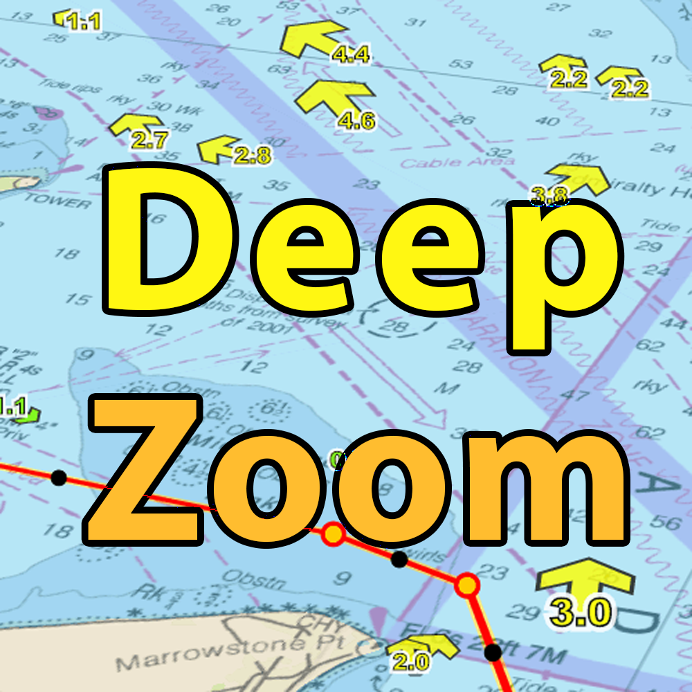
@Tedd Lay out a simple route. This one is for a passage through Deception Passage, Using OpenCPN with tide currents visual.

I lay out the route than click on the tidal sites to see what the tide is doing. The link provides the calculated tide currents at various time point. On this stretch I would examine the tidal information at the critical location. Under the bridge.

I can scroll up and down to decide when is the best time to run through.
The DeepZoom and Coastal Explorer provided further extension of this idea in that the software lets you adjust your departure time for the route then showing the currents when you are supposed to cross the passage. CE also had a rudimentary calculation of cumulated route passage time generating an ETA. When I worked with it, there was a lack of accuracy.
I took their current information and plugged it into a spread sheet and I was able to resolve the issue. I shared it with them but they were too busy with other programming to fix this glitch.
This whole world of routing using computers is an evolving process. It is always best to check your work before you head out.
I do like the GRIB function of OpenCPN. Just would like to more easily apply it. Currently working with LuckGrib on David's Cross Atlantic sailing and really like the results. Will be working with it hear in the PacificNW over the next couple of weeks.
I lay out the route than click on the tidal sites to see what the tide is doing. The link provides the calculated tide currents at various time point. On this stretch I would examine the tidal information at the critical location. Under the bridge.
I can scroll up and down to decide when is the best time to run through.
The DeepZoom and Coastal Explorer provided further extension of this idea in that the software lets you adjust your departure time for the route then showing the currents when you are supposed to cross the passage. CE also had a rudimentary calculation of cumulated route passage time generating an ETA. When I worked with it, there was a lack of accuracy.
I took their current information and plugged it into a spread sheet and I was able to resolve the issue. I shared it with them but they were too busy with other programming to fix this glitch.
This whole world of routing using computers is an evolving process. It is always best to check your work before you head out.
I do like the GRIB function of OpenCPN. Just would like to more easily apply it. Currently working with LuckGrib on David's Cross Atlantic sailing and really like the results. Will be working with it hear in the PacificNW over the next couple of weeks.
Is very helpful to show the currents up in our neck of the woods. But try this exercise instead of Decep[tion Pass:DeepZoom
Go from say Sidney to Friday Harbor.
You get either a flood or an ebb through Spieden Channel and then an ebb or flood through San Juan Channel.
It's got you coming or going. I've never found a way to get beat by one or other other 'cuz you can't make both!
DeepZoom is great to see things like that, but I always check the tables, too. Maybe I'm just old school but I always check large charts before details, rely on tables and not apps, and I hate/despise/reject routes. Want to know how I really feel about routes?
I think they're dangerous and for people who don't want to do their homework. That's how! jssailem
SBO Weather and Forecasting Forum Jim & John
- Oct 22, 2014
- 24,464
I can understand this logic.
There really are no reliable short cuts to safe navigation. I operate with a Trust but Verify attitude about my navigation. It is what enabled me to discover the glitch in the CE software. It did nothing to in danger a user. It just was inaccurate in calculating the ETA. Unless you used that specific feature no one would know.
As with any planning, once you untie the lines and head out onto the water you need to adapt to the conditions. Generally the time lines and anticipated performance metrics are altered by the dynamics of sailing a boat. If you are adaptable to change and adjust, it will be an enjoyable experience.
Navionics doesn’t use the tides or currents for navigation at all. You can see the tides and current at stations, and you can manually change the time to see what they’ll be, but the current doesn’t affect the arrival time and there’s no optimization for it.hen we've sailed where there were tidal currents (Maine and Rhode Island), we used the current and tide info in Navionics for our timing. Not a tidal routing feature that I know of there, but I've never been one to use the routing function in Navionics. Wonder if it does take tides into account. Anyone know?
I suppose, but I have never experienced one at my end of Lake Michigan that impacted my sailing or navigation.Well, there are the seiches, and they can be quite radical at times, depending on where you are and the conditions...
When we've sailed where there were tidal currents (Maine and Rhode Island), we used the current and tide info in Navionics for our timing. Not a tidal routing feature that I know of there, but I've never been one to use the routing function in Navionics. Wonder if it does take tides into account. Anyone know?
Greg