Normally I'd ask this in the summer, but does anyone have any recent info on the southern end of the Swinomish? I don't typically follow the forecast for the strait in the winter, but it looks like there are fewer opportunities to cross if that were what someone was looking to do.
Swinomish channel
- Thread starter forbin
- Start date
jssailem
SBO Weather and Forecasting Forum Jim & John
- Oct 22, 2014
- 23,107
Forbin, Have you read the Swinomish channel SBO Posts?
I have sailed up the channel many times. What is it you have concern? What is your draft?
I have sailed up the channel many times. What is it you have concern? What is your draft?
First Season Cruise- Roche Harbor w Catalina Owners
We set off on May 1 10:48 for the 1st Cruise of the season. Weather has been accommodating. Partial sunshine. Our first leg took us up Saratoga Passage NW to Anacortes. Getting out of Everett their was hope for a SE breeze to carry us. In typical PacNW fashion the wind built out of the West...
forums.sailboatowners.com
I read most of the posts, but I don't recall seeing many this year (maybe shouldn't be a surprise.) For a while they were posting updates here Swinomish Channel Watch - Port of Skagit and it seemed like they were dredging every couple years, but I can't find any "official" info, so I usually ask here.
Draft is my concern, ours is 7' 3". I've been through a handful of times but my last boat was almost a foot less, and I remember it being significantly shallower than I expected in a couple areas despite going through on I believe a +5 (maybe 3 years ago).
Brian
Draft is my concern, ours is 7' 3". I've been through a handful of times but my last boat was almost a foot less, and I remember it being significantly shallower than I expected in a couple areas despite going through on I believe a +5 (maybe 3 years ago).
Brian
jssailem
SBO Weather and Forecasting Forum Jim & John
- Oct 22, 2014
- 23,107
Here is the info I has helped me manage the Ditch.
First You should probable seek the higher tide feasible. I powered through on a 36' Catalina with a 6 ft draft. The owner was nervous as we approached #8 Marker and the east end of the breakwater. The depth meter as recording 12-6" of water under the keel. We crawled through at 2 knots. Never touched. Tidal level was at +1. I think you should have no problem as a +2.
The areas of concern are circled in red.
The first issue Circled in red (assuming you are coming from the north), is to stay to the north side of the channel center (use the range marker) as you approach the end of Goat Island. Not on the north edge of the channel as there are rocks around the bases of the north side markers. They are visible at minus tide and they extend out 6-10 yards from the marker piling.
Water enters the channel between the end of goat island and the start of the breakwater. There is bound to be some shoaling in that area, near the beginning of the break water on the south side. I stay north edge of center channel. The shoaling does not appear to extend more 30% from the South side.
We saw a shallowing of the water near the # 8 Red marked on the south side. Again stay closer to mid channel.
When you get to the South end of the ditch stay to the north side of the center as giver yourself room from to clear the channel before you turn south. The tidal currents here flow north and south as well as out of the ditch. The currents are carrying silt from the bays either side of the ditch. So give the end channel markers some room on both the north and south edges. Don't cut the corner!
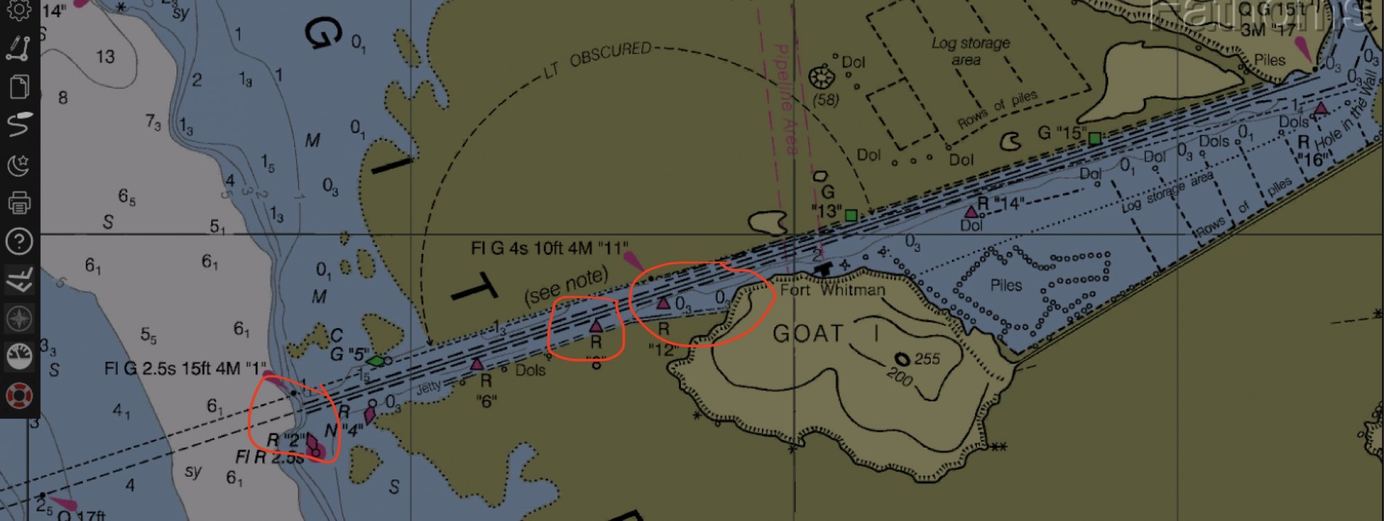
On a high tide you should have a safe passage.
On the other hand you can run south through Rossario Straight and duck in to the Saratoga passage through Deception Passage. Or you can cruise down to the SouthWest end of Whidbey and ride the flooding tide through Admiralty Strait.
Oh so many fun options.
Hope it helps. PM me if you need more.
First You should probable seek the higher tide feasible. I powered through on a 36' Catalina with a 6 ft draft. The owner was nervous as we approached #8 Marker and the east end of the breakwater. The depth meter as recording 12-6" of water under the keel. We crawled through at 2 knots. Never touched. Tidal level was at +1. I think you should have no problem as a +2.
The areas of concern are circled in red.
The first issue Circled in red (assuming you are coming from the north), is to stay to the north side of the channel center (use the range marker) as you approach the end of Goat Island. Not on the north edge of the channel as there are rocks around the bases of the north side markers. They are visible at minus tide and they extend out 6-10 yards from the marker piling.
Water enters the channel between the end of goat island and the start of the breakwater. There is bound to be some shoaling in that area, near the beginning of the break water on the south side. I stay north edge of center channel. The shoaling does not appear to extend more 30% from the South side.
We saw a shallowing of the water near the # 8 Red marked on the south side. Again stay closer to mid channel.
When you get to the South end of the ditch stay to the north side of the center as giver yourself room from to clear the channel before you turn south. The tidal currents here flow north and south as well as out of the ditch. The currents are carrying silt from the bays either side of the ditch. So give the end channel markers some room on both the north and south edges. Don't cut the corner!
On a high tide you should have a safe passage.
On the other hand you can run south through Rossario Straight and duck in to the Saratoga passage through Deception Passage. Or you can cruise down to the SouthWest end of Whidbey and ride the flooding tide through Admiralty Strait.
Oh so many fun options.
Hope it helps. PM me if you need more.

Nice post, John. Our draft is five feet, Brian. A safe transit for our boat requires a +1 foot tide state. Never had an issue at that state, so for your boat I would transit at a +3 tide state. The southern end is the thinnest part of the channel, especially around channel marker 6 and 8. Also, plan on following an ebb heading north and a flood south waiting at least an hour after flood/ebb slack before transiting. That way you get the current flow advantage, which I've seen at over 3 knots, but typically 2.5.
Last edited:

@jssailem Thanks, that is a great post, very helpful.
Thanks @Terry Cox.
We'll see how the weather looks early next week, I'd definitely choose one of the outside routes if the weather aligns.
Thanks @Terry Cox.
We'll see how the weather looks early next week, I'd definitely choose one of the outside routes if the weather aligns.
"I think I can, I think I can, I think I can.” Nope.
We have planned a number of times over the past 8 years to transit that channel particularly from the South. Big ideas, well planned out and thought through . . . right to the entrance. Nope. Each time we, as in I, lost the nerve and continued on through Deception Pass up Rosario to follow on destinations. Denied but remains on my bucket list.
Maybe with your guidance, John, and the expected border opening, we will succeed in the transit.
jssailem
SBO Weather and Forecasting Forum Jim & John
- Oct 22, 2014
- 23,107
Buddy boating is a great way to sail.Maybe with your guidance, John, and the expected border opening, we will succeed in the transit.
I agree . . . but in small douses.Buddy boating is a great way to sail.
Ha, I always end up just far enough in that I think it’s more risk to turn around so have to keep going!Big ideas, well planned out and thought through . . . right to the entrance. Nope.
No worries. It's only mud/sand mix. If you get stuck, just crack a brew and wait.
Wrote an article sometime ago about transiting the ditch. Worth another read here: Transiting The Ditch, er Swinomish Channel
Wrote an article sometime ago about transiting the ditch. Worth another read here: Transiting The Ditch, er Swinomish Channel
BookmarkedNo worries. It's only mud/sand mix. If you get stuck, just crack a brew and wait.
Wrote an article sometime ago about transiting the ditch. Worth another read here: Transiting The Ditch, er Swinomish Channel
Posted the following in another thread awhile ago, but thought it worthy of another redux.
"Several years ago, in my early days of transiting the ditch, heading south for Penn Cove on a late strong ebbing current with about a +1.5 tide state, I made the turn out of the gorge heading west, put the genoa up in a nice southerly, with my eight foot off set alarm pinging. As I approached #6 buoy, with about 0.5 feet beneath the keel, I felt the first mud tug on the keel, then another a bit stronger. Right at the buoy the boat stopped and began turning sideways in the channel from the current flow pressure.
A combination of wind pressure on the genoa and current pressure on the hull, the boat heeled over enough to reduce draft, which allowed the boat to skitter past the buoy into deeper water. That did cause a bit of a sweat, but had it been any later I would have been stuck there for hours waiting for the tide change to bring in enough flooding waters. A close call."
I've learned much over the years since then and managed to put my experience into practice, thus avoiding such an incident from happening again.
I saw this in another post, and it made me go back to Navionics and look again, and makes me think I made a basic error, but got lucky because I used what I thought was a tide height with a huge margin of error (+5 for my old boat).
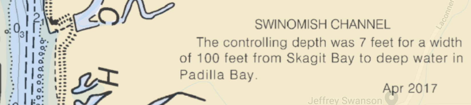
"Trying to figure out if we should attempt deception pass at slack tide or have the option of going through the swinomish channel (La Conner). Chart says the channel's controlling depth is 6.8ft for 100ft wide."
Navionics shows *12 ft* almost all the way through the south part of the channel, and notes on the chart, which are not obvious *with different zoom levels* indicate something similar to this one (grabbed off a different chart that was easier to copy). I also see other notes along the Navionics charts indicating the same thing at various spots.
So I was using 12 ft as my mllw level (on average, knowing there was silting). I'm not even sure I originally got 12 feet from anymore, it was a while ago...but...
PHEW!
Last edited:
jssailem
SBO Weather and Forecasting Forum Jim & John
- Oct 22, 2014
- 23,107
It is all about the definitions : NOAA 2004channel's controlling depth is 6.8ft for 100ft wide
CENTERLINE CONTROLLING DEPTH. The controlling depth of a waterway which applies only to the center of the waterway; it is usually the result of a reconnaissance-type survey consisting of only a few lines of soundings which do not provide adequate coverage to determine the controlling depth of the entire waterway.
CONTROLLING DEPTH. (1) The least depth in the approach or channel to an area, such as a port or anchorage, governing the maximum draft of vessels that can enter. (2) The least depth within the limits of a channel; it restricts the safe use of the channel to drafts of less than that depth. The centerline controlling depth of a channel applies only to the channel centerline; lesser depths may exist in the remainder of the channel. The mid-channel controlling depth of a channel is the controlling depth of only the middle half of the channel.
DEPTH. The vertical distance from a given water level to the bottom. The charted depth is the vertical distance from the tidal datum to the bottom. The least depth in the approach or channel to an area, such as a port or anchorage, governing the maximum draft of vessels that can enter is called the controlling depth.
My chart says seven feet at the south entrance at zero tide state. Hah!Navionics shows *12 ft* all the way through the south part of the channel,
At zero tide state, nope.Chart says the channel's controlling depth is 6.8ft for 100ft wide."
jssailem
SBO Weather and Forecasting Forum Jim & John
- Oct 22, 2014
- 23,107