The other day I got a request to help with weather forecasting by one of our fellow SBO sailors.
I am not a passage Weather Forecaster... which my partner @JamesG161 here on the Weather and Forecasting Forum reminded me. For one my knowledge has been learned on the job, through study of weather data, sailing experience, and shared knowledge. I do not have a degree in what is often referred to as "Weather Voodoo".
I recently read a recommended book by a fellow sailor "And soon I heard a Roaring Wind: A Natural History of Moving Air" by Bill Steever that gave a good historical timeline to our quest for a reliable way to forecast the weather.
I thought that I would share a couple of the tools I employed to help my fellow sailor to decide on his weather query.
Know that trying to see the future of weather is like looking into a tunnel filled with smoke. For the first hundred or so yards you may think you can see what is coming but the images fade in and out. Caution and only the near 10-15 yards is what may be reliable.
First to get a MACRO idea of what is happening in the Pacific, I use Windy.Com and zoom out to see the general pattern of reported weather. I was being asked to guess 10 days into the future. To do that I use the European Weather Model (ECMWF) to show what they are forecasting. I know that this is a best guess by a computer model and is maybe 30% accurate 10 days out.
I collected the following images for our discussion.
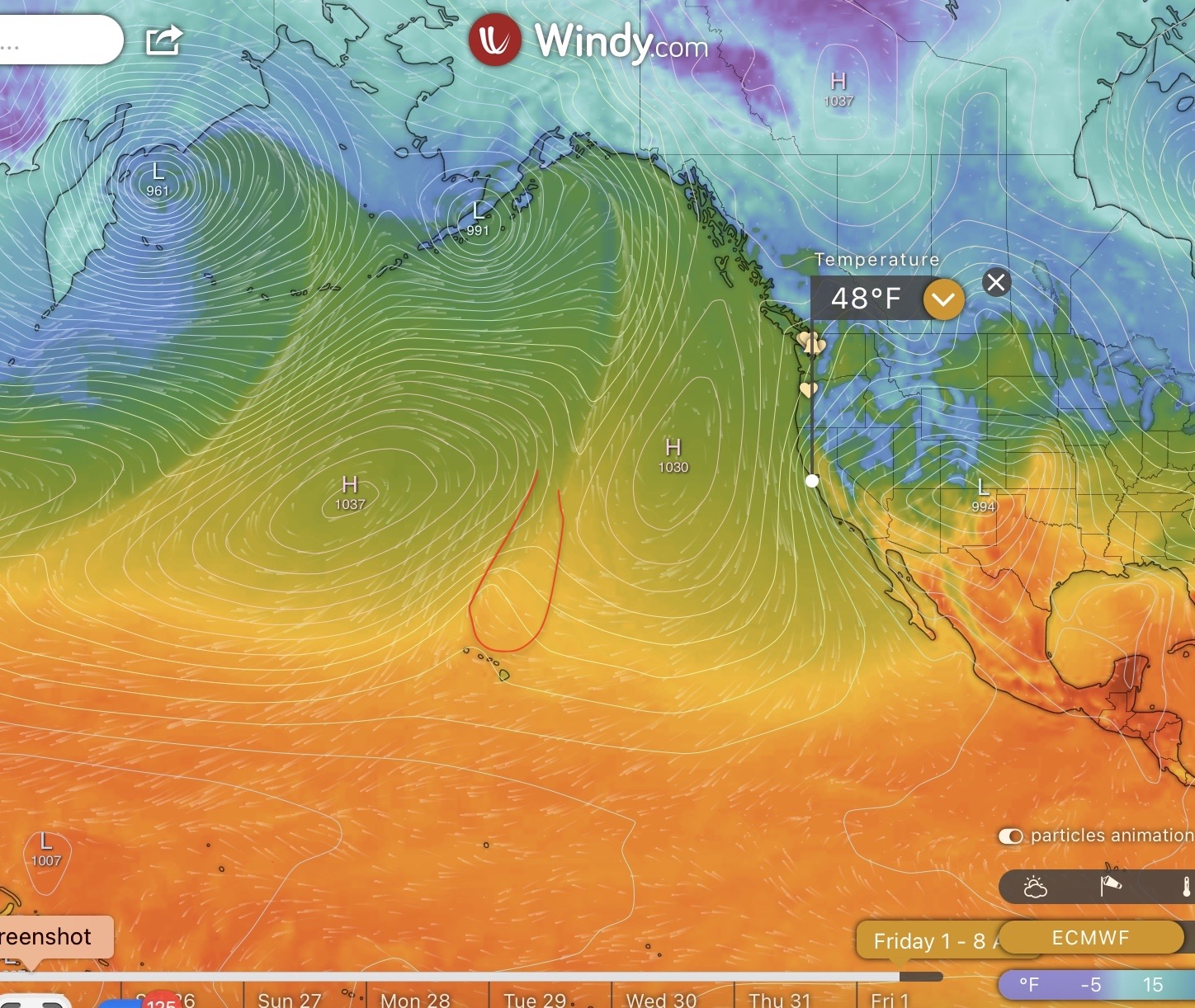
This first image centers on the Hawaiian Islands and is a forecast for 1 April 2022. It shows the surface Temperature, the High Pressure Cells and the specific report for an area just off the San Francisco Bay. This will become important in the next image.
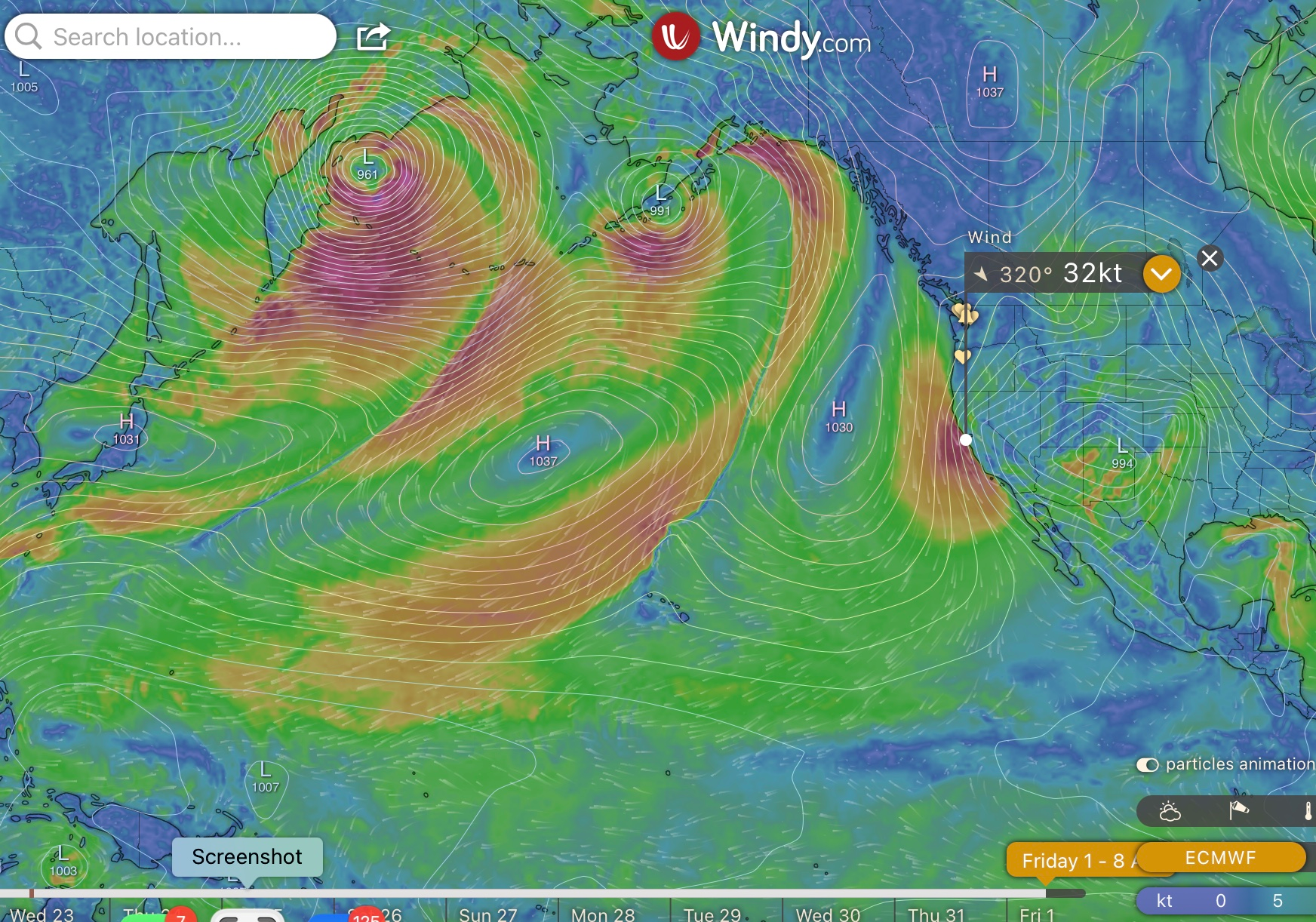
This image is wind patterns around the High Pressure Cells and for that SF Bay region. Note that the winds circle clockwise around High Pressure Cells and when the Iso Bars (white lines of common pressure) get close together the wind speeds increase. The model is indicating that the High pressure cell near the West coast will be pressing up against a Large Low pressure cell located somewhere over Colorado/New Mexico. On the Pacific Coast the winds are increasing as the High cell tries to move the Low cell eastward. Winds in the SF Bay area could be in the 32Knot range. Now for a sailor off the coast that might not be too bad. The winds out of the NNW (320 degrees) would be on the aft beam. The currents along the coast generally run from North to South. This would put the boat in a following sea and a following wind on the first of April.
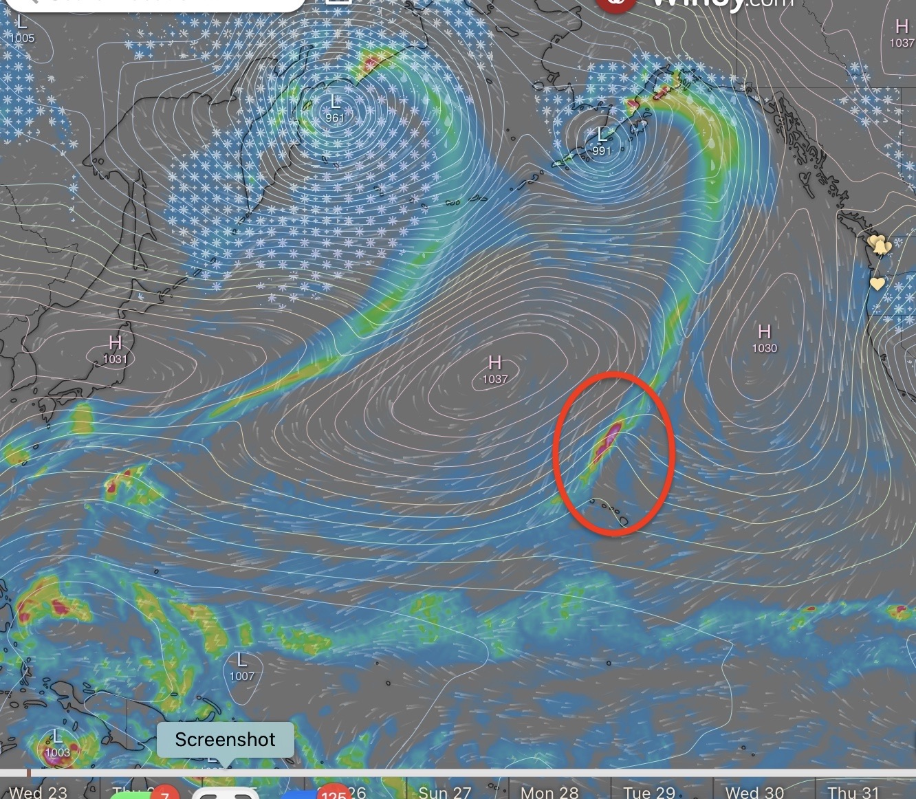
I raised a red flag for my sailor buddy. I saw a ripple in the pressure cells just north of the Hawaiian islands. That wave ripple in the pressure lines shows up on this image of the moisture as a squall area. While it is in the middle of the ocean on this model, it will not stay there. It will be moving. There is no clear guide to how fast or where or what it will develop into. It should be an area of concern for Skipper thinking about heading out into the ocean some 12 to 14 days in the future around the 1st to 8th of April.
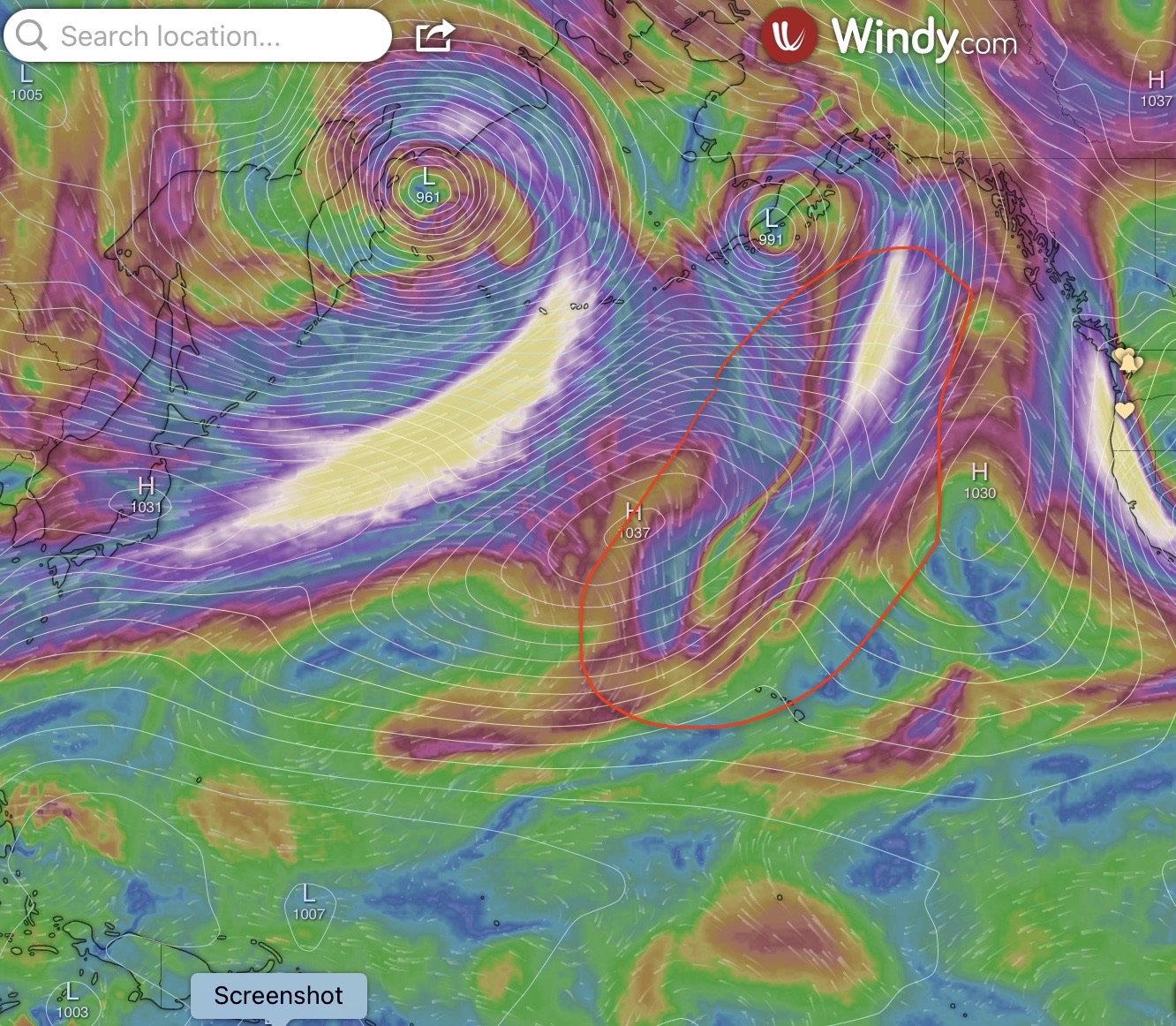
This upper air look at the jet streams in the Pacific give a glimpse at the powers moving the cells. The areas in white are areas of 100 plus knot winds.
This was start of the discussion from the point of a skipper planning a passage.
Hey John...
Perhaps it’s near time for a NWP weather forecast update? A friend is looking at a transit
I am not a passage Weather Forecaster... which my partner @JamesG161 here on the Weather and Forecasting Forum reminded me. For one my knowledge has been learned on the job, through study of weather data, sailing experience, and shared knowledge. I do not have a degree in what is often referred to as "Weather Voodoo".
I recently read a recommended book by a fellow sailor "And soon I heard a Roaring Wind: A Natural History of Moving Air" by Bill Steever that gave a good historical timeline to our quest for a reliable way to forecast the weather.
I thought that I would share a couple of the tools I employed to help my fellow sailor to decide on his weather query.
Know that trying to see the future of weather is like looking into a tunnel filled with smoke. For the first hundred or so yards you may think you can see what is coming but the images fade in and out. Caution and only the near 10-15 yards is what may be reliable.
First to get a MACRO idea of what is happening in the Pacific, I use Windy.Com and zoom out to see the general pattern of reported weather. I was being asked to guess 10 days into the future. To do that I use the European Weather Model (ECMWF) to show what they are forecasting. I know that this is a best guess by a computer model and is maybe 30% accurate 10 days out.
I collected the following images for our discussion.
This first image centers on the Hawaiian Islands and is a forecast for 1 April 2022. It shows the surface Temperature, the High Pressure Cells and the specific report for an area just off the San Francisco Bay. This will become important in the next image.
This image is wind patterns around the High Pressure Cells and for that SF Bay region. Note that the winds circle clockwise around High Pressure Cells and when the Iso Bars (white lines of common pressure) get close together the wind speeds increase. The model is indicating that the High pressure cell near the West coast will be pressing up against a Large Low pressure cell located somewhere over Colorado/New Mexico. On the Pacific Coast the winds are increasing as the High cell tries to move the Low cell eastward. Winds in the SF Bay area could be in the 32Knot range. Now for a sailor off the coast that might not be too bad. The winds out of the NNW (320 degrees) would be on the aft beam. The currents along the coast generally run from North to South. This would put the boat in a following sea and a following wind on the first of April.
I raised a red flag for my sailor buddy. I saw a ripple in the pressure cells just north of the Hawaiian islands. That wave ripple in the pressure lines shows up on this image of the moisture as a squall area. While it is in the middle of the ocean on this model, it will not stay there. It will be moving. There is no clear guide to how fast or where or what it will develop into. It should be an area of concern for Skipper thinking about heading out into the ocean some 12 to 14 days in the future around the 1st to 8th of April.
This upper air look at the jet streams in the Pacific give a glimpse at the powers moving the cells. The areas in white are areas of 100 plus knot winds.
This was start of the discussion from the point of a skipper planning a passage.

