- Oct 22, 2014
- 23,789
A post in the Sailors lounge regarding small sail boats and large freighters, got me thinking but sailing in our Puget Sound / Salish Sea waters.
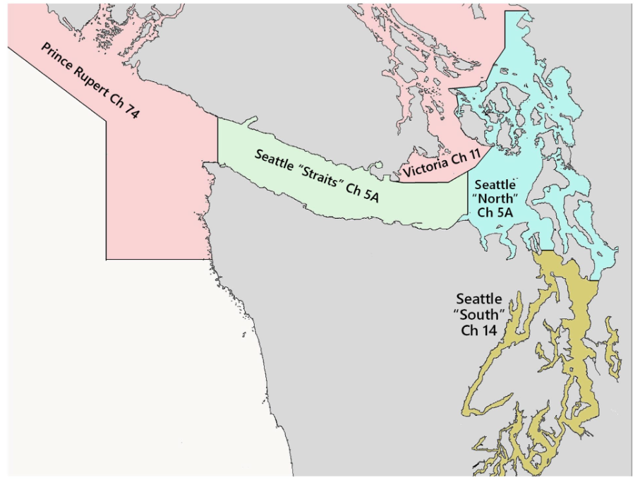
If you have seen a chart you will notice the "Big Ship Highway" that runs down the middle of the Salish Sea. The Strait of Juan de Fuca and its approaches, Puget Sound, the San Juan Island Archipelago, Haro Strait, Boundary Pass, and the Strait of Georgia are regions of the Salish Sea collectively managed by Seattle, Prince Rupert, and Victoria Traffic Services. It is like a controlled "water space", the pathway for big ships.
If you have not read the magenta print on you chart perhaps it is a good time to update your cruising knowledge. If you know what the VTS is do you know the way to best contact the ships bridge heading towards your crippled sailing vessel that is in his path?
What should you do when the VTS calls you out? A couple of years ago I heard
"Hadley, Hadley Hadley - Seattle Traffic!" on the VHF.
"Hadley here."
"Hadley, Change to Ch 5A."
"Go ahead Seattle Traffic. "
"Hadley we have you near Admiralty Inlet, North side of Channel, what are you intentions."
"Seattle Traffic, Hadley is abeam Admiralty Head on a course of 315T. I intend to hold this course past Partridge point and cross the VTS west of Partridge Point."
" Hadley be advised we have a Tug with tow rounding Partridge Point and will be using the VTS Northern Lane. Stay North of the VTS until you pass Partridge Point. " ( What, That is like running down the wrong side of the interstate)
"Thank you Seattle Traffic for the information. Hadley will hold course and maintain north of the VTS. I'll watch out for your Tug and tow. Good Day. Hadley back to 16."
You need to determine your vessel’s participation requirements, whether FULL, PASSIVE or MINIMAL, and what these requirements are, while operating in U.S. territorial waters or while operating in Canadian waters.
Up here in the Puget Sound the ships transit the northern section of the Sound often at the same speed they have cruised the open ocean. 15-20 knots in not unusual. They cruise within the TSS (Traffic Separation Scheme) under the monitoring and control of VTSPS (Vessel Traffic Service Puget Sound). This is an international effort that affects all vessels sailing the waters of the Puget Sound. It involves VTS Puget Sound or Seattle Traffic , Victoria MCTS or Victoria Traffic and Prince Rupert MCTS or Prince Rupert Traffic .
The purpose of Vessel Traffic Service Puget Sound is to facilitate the safe, secure and efficient transit of vessel traffic to assist in the prevention of collisions or groundings that could cost lives, property damage, or subject the pristine waters of the Salish Sea to environmental harm.
All boaters are required to be knowledgeable of the rules governing the transit of vessels in the area.
https://www.pacificarea.uscg.mil/Portals/8/District_13/sectpugetsound/VTSpugetsound/2019_VTSPS_UserManual.pdf


