Lookout for Abandoned Piers

Feb 21, 2013
4,638
Hunter 46 Point Richmond, CA
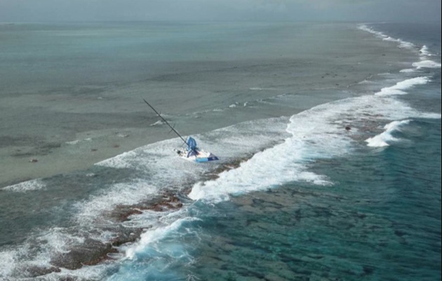
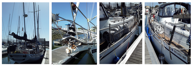
I just met a first-time sailor who purchased his first sailboat, an Island Trader Ketch 41, in Canada.......retiree with a bucket list? He then sailed over 800 miles from Canada to the San Francisco Bay through rough weather and seas without incident over 3 months, sailing in selected weather windows. Then on his final approach to the Emery Cove Marina in the eastern San Francisco Bay in fog without a functioning radar, albeit he had a navigation display with GPS he set a straight line course to the marina from the center of the San Francisco Bay and collided with the un-marked, partially submerged and abandoned Berkeley Pier Berkeley Pier - Wikipedia that extends 2.5 miles from the western edge of Berkeley into San Francisco Bay. Unfortunately the collision resulted in damage to the bow sprit and starboard toe rail, escaping without any structural damage the sailor told me. The sailboat is now for sale. He should be glad he was not sailing to Richmond since it he hit the Richmond Channel jetty (just north of the dotted line) he could have gone aground and possible sunk the boat as what happened to a large ferro cement sailboat did a number of years ago on a July 4th night.

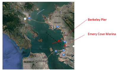
I know to avoid this unsafe obstruction. Pretty sure the pier shows up on GPS (will confirm on my next sail) but I know it shows up clearly on the navigation display radar, even in fog.
1624049273015.png
1624049285481.png
 
Last edited:
Mar 6, 2008
1,078
Catalina 1999 C36 MKII #1787 Coyote Point Marina, CA.
San Francisco sailors know their backyard and have been warned not to cross Berkeley Pier, but some still do.
It seems that your GPS would have identified the Pier and it's markers to guide you safely to navigate around it.
I glad you made it across safely.
 
May 17, 2004
5,032
Beneteau Oceanis 37 Havre de Grace
Scary that it’s 2.5 miles, not just in close to shore.

Here’s what it looks like on Navionics at a moderate zoom:
1624052690436.png


That dashed line would probably just blend in with the other boundary marker lines to me. Once you zoom in it’s a little better with a label and ActiveCaptain marker, but I still don’t love it:
1624052848628.png
 
  • Like
Likes: sail sfbay
Feb 21, 2013
4,638
Hunter 46 Point Richmond, CA
Davidasailor26.......you are correct!!......one needs to make very certain, when sailing north or south on the east side of the bay, that you look for and stay outside the red marker at its western end of the pier AND do not set a course to the east of that red marker when sailing or motoring to/from Emery Cove Marina or Emeryville Marinas. Read your charts and GPS carefully BEFORE you sail in new water and if in doubt operate with radar.
 
Last edited:
Feb 26, 2004
22,760
Catalina 34 224 Maple Bay, BC, Canada
WADR, the guy was a nincompoop. Stupid and irresponsible, too.

Sure, I sailed SF Bay for almost 20 years. But golly before I set sail in a rental boat from Cass' Marina in Sausalito, I looked at a chart! When we started sailing our own boats in 1983 we devoured charts. We even bought books about Sailing The Bay (Kimball Livingston).

I sailed our boat up to Canada in 2016. Once I got past Pt. Reyes, we went places I had never been before. For six weeks. I didn't do it blind, I brought charts and guidebooks.

Once I got here I bought the local chartbook for the Gulf Islands and studied it. Before I went sailing around, and often since.

For goodness sake, the guy was incompetent at best, and I don't care how far he sailed to get there.
 

Rick D

.
Jun 14, 2008
7,132
Hunter Legend 40.5 Shoreline Marina Long Beach CA
San Diego Bay entrance has one as well. Boats go aground there in daylight much less at night.
 
Jun 2, 2007
403
Beneteau First 375 Slidell, LA
Another example of why I really, really hate vector charts. And NOAA is discontinuing raster charts! Arrgh!
At least I still have my collection of paper charts.
 
Oct 22, 2014
20,995
CAL 35 Cruiser #21 moored EVERETT WA
Some boat owners believe charts are the key to safe boating others choose their own path.

And it’s not always the small boats.
1624108544339.jpeg


Opps. Missed the entrance by just 75 feet.