• Sailing is all about the Weather.

    Big into the exploration of Atlantic Hurricanes since Katrina came uninvited into his world, James (Jim) Gurley (JamesG161) has followed every Tropical Storm birthed in Atlantic, Gulf and Caribbean waters since. Being a boater, he knows that we often need more time to prepare than we get from the TV weather folk. Jim relies on the science of storm development to share early warning info with friends and fellow boaters.

    Early in 2018, Jim and John Shepard, (JSSailem) started to chat about the weather data available. John asked Jim to help forecast Pacific NW storms, and this morphed into discussions on weather forecasting.

    For John, sailing in the PNW is sometimes hit and miss. One day is ugly, then a string of beautiful days but no wind, followed by a series of blue-sky days and 12 knot breezes. Being ready for those great sailing days means you need to look to the Pacific Ocean and what is brewing. John has been into Pacific NW Weather since the 1970’s when his first PNW November storm hit bringing more than 40 days and 40 nights of continual rain.

    Together we want to share information, new APPs, safety, and thoughts about letting the weather help you. Identify some of the resources for sailors and help prepare you for your next sailboat outing.

    It is far better to go out on the water knowing what to expect in weather terms, than to be out on the water and see dark ominous clouds suddenly appear, unprepared.

...It's the most wonderful time of the year

Oct 22, 2014
21,104
CAL 35 Cruiser #21 moored EVERETT WA
It is a wonderful time of the year for the Weather honchos...

NOAA - the National Hurricane Center is at rest while we await the season. It is a time for thinking about what drives the weather and to prognosticate about what might happen this year.

Tropical Weather Outlook
Issuance will resume on June 1st or as necessary.​
Tropical Weather Discussion
2154 UTC Mon Apr 6 2020​
There are no tropical cyclones in the Atlantic at this time.
The Atlantic hurricane season runs from June 1st through November 30th.
[TH]
Atlantic - Caribbean Sea - Gulf of Mexico​
[/TH]​

Tropical Weather Outlook
Issuance will resume on May 15th or as necessary.​
Tropical Weather Discussion
2015 UTC Mon Apr 6 2020​
There are no tropical cyclones in the Eastern North Pacific at this time.
The Eastern North Pacific hurricane season runs from May 15th through November 30th.
[TH]
Eastern North Pacific (East of 140°W)​
[/TH]​

Tropical Weather Outlook
Issuance will resume on June 1st or as necessary.​
There are no tropical cyclones in the Central North Pacific at this time.
The Central North Pacific hurricane season runs from June 1st through November 30th.
[TH]
Central North Pacific (140°W to 180°)​
[/TH]​

As you can see for NOAA there is another Month and a bit until we traditionally see "tropical cyclones" develop in the Eastern Pacific. That is considered the waters of the Western beaches of Mexico and Central America.

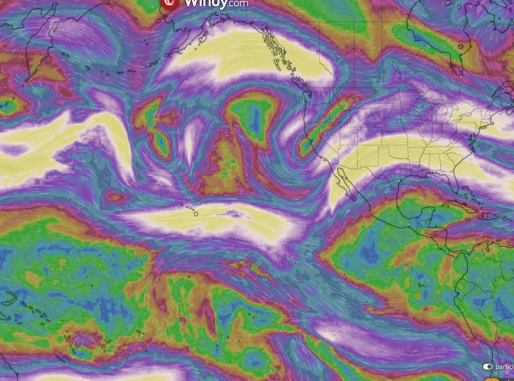
What Jim and I have been watching is the changing of the Jet Stream. Once strongly whipping linke a singular wave around the Arctic Circle stirring up winter and urging it down over Canada and the USA, now is starting to divide and usher in a spring/summer Tropical Jet Stream.

Viewed here at 10Km above the Northern Pacific you can see the white area of wind 100knts plus dividing into 2 bands over the pacific and heading towards the western edge of North America.

JS Northern Pacific 9APR.JPG


Here you can see at the surface the Low and High Pressure cells that are being dragged across the surface.
JS Northern Pacific Surf 9APR.JPG


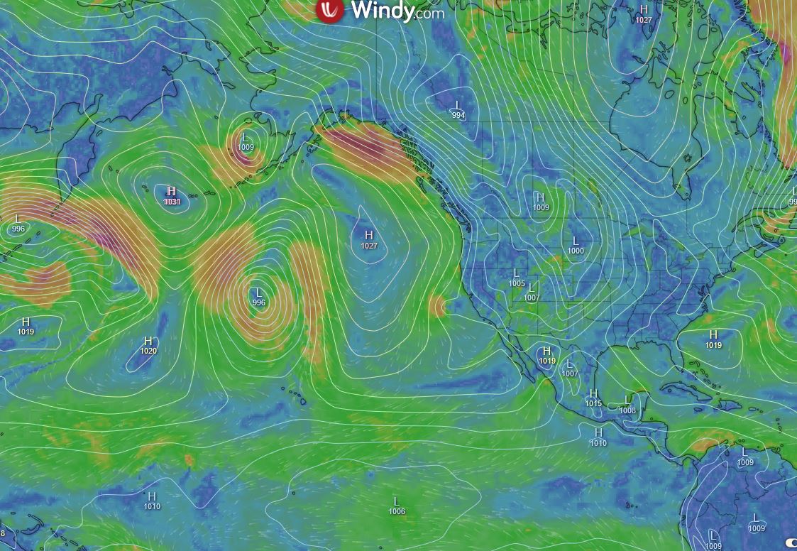
It is this intersection that Jim and I watch and attempt to interpret as we wonder what Mother Nature has brewing for us sailors.
 
Jan 5, 2017
2,265
Beneteau First 38 Lyall Harbour Saturna Island
The west coast will have perfect sailing weather this summer. The North Pacific High will be strong and stable, the winds will be 10 to 15 out of the N.W. and we will be told to stay home. Is there no justice?
 
Oct 22, 2014
21,104
CAL 35 Cruiser #21 moored EVERETT WA
I know Michael. Seems so unfair. Hopefully the curve will flatten and we can again cruise the Salish Sea.
 
Feb 14, 2014
7,423
Hunter 430 Waveland, MS
Once strongly whipping linke a singular wave around the Arctic Circle stirring up winter and urging it down over Canada and the USA, now is starting to divide and usher in a spring/summer Tropical Jet Stream.
Here is the 5 day forecast for both parts of the Jet Stream. [4/6/2020]
Animation of Jet Stream Forecasts for North America

Note the southern or Tropical Jet Stream dominate the Southern part of USA and then literally push the Polar JS back north in the 5 day out.

Spring has sprung in the South.:biggrin:

The more we see the Jet Stream "push" each other, the more severe the spring weather will be on the "Surface Maps"

We are starting late this spring, for severe weather.
Jim...
 
Oct 19, 2017
7,746
O'Day 19 Littleton, NH
Here is an interesting descriptive overview of the Jetstream Analysis maps. The link was provided at the bottom of the page JamesG linked to.
The relationship between converging and diverging jetstream air and high and low pressure resulting in fair or foul weather is nicely summarized.
CRWS Background Information: Jet Stream Maps
"As air races through the sinuous jet-stream pattern, there are some parts of the pattern where air tends to converge, thereby increasing the total weight of air above the earth's surface in those areas, which implies higher pressure at the earth's surface below. Moreover, convergence of air within the jet stream tends to force air beneath the jet stream downward. As air descends in the atmosphere, the pressure on it increases and compresses it, thereby warmingthe sinking air, which evaporates any existing clouds or prevents clouds from forming in the first place. Such areas generally experience clear weather.

However, air in other parts of the jet stream pattern tends to diverge, which reduces the total weight of air above the surface which implies lower surface pressure beneath those parts of the jet stream. Moreover, divergence of air within the jet stream tends to induce air below to ascend to replace the diverging air. Rising air encounters lower atmospheric pressure, so the rising air expands and coolsby virtue of the expansion. If the rising air cools enough, clouds form in it and may eventually produce precipitation. Regions of the atmosphere where air within the jet stream aloft diverges, causing surface pressure to fall and forcing air within the troposphere below to rise and cool, leading to large-scale cloud formation and possibly precipitation, are associated with mid-latitude wave cyclones and their accompanying warm and cold fronts."

-Will (Dragonfly)
 

WayneH

.
Jan 22, 2008
1,039
Tartan 37 287 Pensacola, FL
Yep, it's Spring here in central Texas. But my boat is in Pensacola and I'm not sure I can get out of Louisiana once I get into Louisiana. I wonder how I can prove to the Florida Highway Patrol and the Texas Department of Public Safety that I did NOT stop in Louisiana?
 
Oct 22, 2014
21,104
CAL 35 Cruiser #21 moored EVERETT WA
Those multi colored beads hanging from your neck and the rear view window and the bumper sticker “
1586309186997.jpeg

would indicate a lack of veracity in your story.
 
Feb 14, 2014
7,423
Hunter 430 Waveland, MS
Take Interstate 12 in Baton Rouge and bypass New Orleans.
I-10 is still flowing East bound to Pensacola.
Jim...

PS: Wave at my boat in Exit 16 I-10 in Mississippi. You can see my mast from I-10 daytime.;)
 
Jun 21, 2004
2,533
Beneteau 343 Slidell, LA
Shouldn't be a problem getting into Florida if you have Texas license plates. They're only stopping vehicles with LA plates on I-10 and vehicles from NY & NJ on I-95.
 
  • Helpful
Likes: JamesG161