• Sailing is all about the Weather.

    Big into the exploration of Atlantic Hurricanes since Katrina came uninvited into his world, James (Jim) Gurley (JamesG161) has followed every Tropical Storm birthed in Atlantic, Gulf and Caribbean waters since. Being a boater, he knows that we often need more time to prepare than we get from the TV weather folk. Jim relies on the science of storm development to share early warning info with friends and fellow boaters.

    Early in 2018, Jim and John Shepard, (JSSailem) started to chat about the weather data available. John asked Jim to help forecast Pacific NW storms, and this morphed into discussions on weather forecasting.

    For John, sailing in the PNW is sometimes hit and miss. One day is ugly, then a string of beautiful days but no wind, followed by a series of blue-sky days and 12 knot breezes. Being ready for those great sailing days means you need to look to the Pacific Ocean and what is brewing. John has been into Pacific NW Weather since the 1970’s when his first PNW November storm hit bringing more than 40 days and 40 nights of continual rain.

    Together we want to share information, new APPs, safety, and thoughts about letting the weather help you. Identify some of the resources for sailors and help prepare you for your next sailboat outing.

    It is far better to go out on the water knowing what to expect in weather terms, than to be out on the water and see dark ominous clouds suddenly appear, unprepared.

ITCZ or The Doldrums

JamesG161

SBO Weather and Forecasting Forum Jim & John
Feb 14, 2014
7,744
Hunter 430 Waveland, MS
We are going to focus on this as part of Hurricane Forecasting but it applies to all Sailors...

Inter-Tropical Convergence Zone = ITCZ

Every day NOAA puts out a forecast on the Tropical Atlantic

Atl_Tropics-2.gif


Note the ITCZ in the Red Band and its association with the...

West African Monsoon Trough.

Wind-rainfall-patterns-monsoon-West-African.jpg.gif


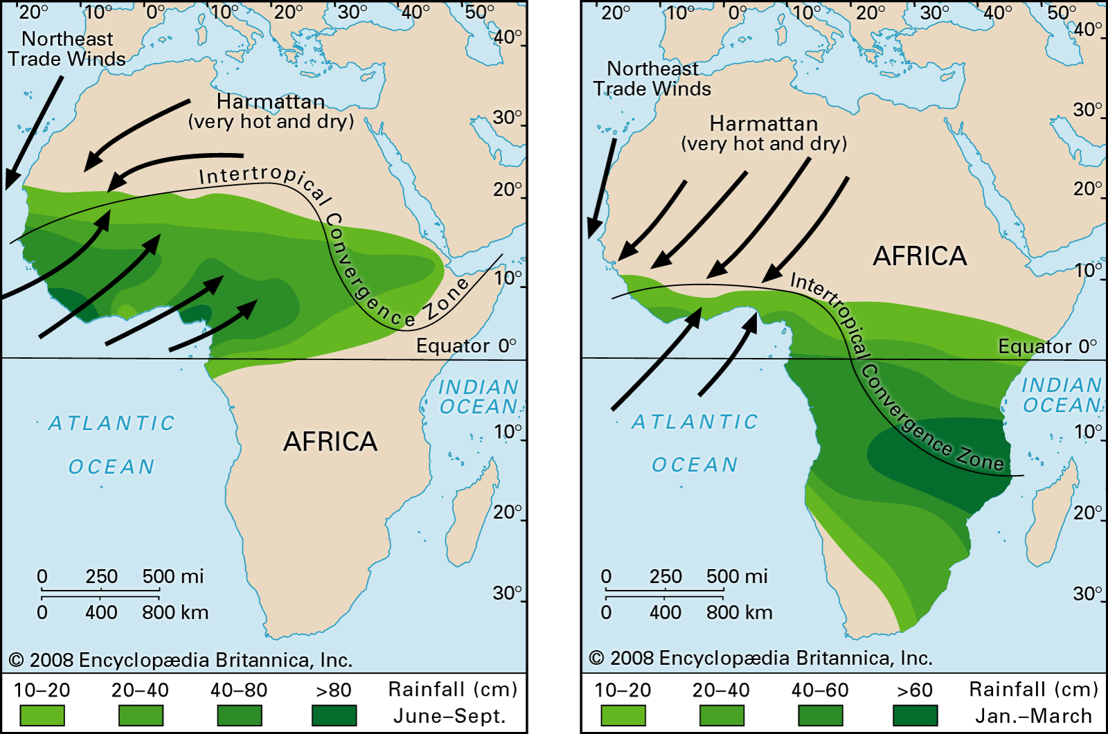
The Monsoons cycle North and South during the year.

During August and September the Monsoons line up to create LOW pressures Spinoffs that enter the Atlantic and one reason NOAA expects a higher than Normal 2022 Season.

More to come on this subject..
Jim...
 
Last edited:

JamesG161

SBO Weather and Forecasting Forum Jim & John
Feb 14, 2014
7,744
Hunter 430 Waveland, MS
When the ITCZ has Windless Day or in Sailing terms...

Doldrums

These can occur especially preceding and following a Tropical Wave.

A Tropical Wave precedes the LOW pressure wave.

Just like Surface Waves... HIGHs and LOWs

If you note the NOAA forecast above, there are many Tropical wave fronts.

They track along the ITCZ in the Westerlies or the Trade Winds.

The speed of the Trade Winds determine how a Storm Strengthens or Intensifies.

Or

Accumulated Cyclone Energy or ACE

More to come on how NOAA predicts a more active season.
Jim...


.
 

JamesG161

SBO Weather and Forecasting Forum Jim & John
Feb 14, 2014
7,744
Hunter 430 Waveland, MS
ENSO or La Niña/El Niño Pacific Weather Cycle

This will be a short description.

NOAA predicted a more active Hurricane Season since we are in...

La Niña

Which brings more rain to the USA, but sets up a huge HIGH pressure Cell in the PNW and Central Atlantic.

LosNinoshighpressureHR.jpg


Note the Polar Jet Stream and its direction.

We are in a rare event of 3 - La Niña in a row or 3 years running.
Last time was in the 1970's

The steering currents in the Atlantic tend to follow the Jet Stream.

Highs.png


Today's weather showing the Dominate HIGHs

This should prevail during August and September of this Hurricane Season 2022.

Jim...