high water?
- Thread starter jon hansen
- Start date
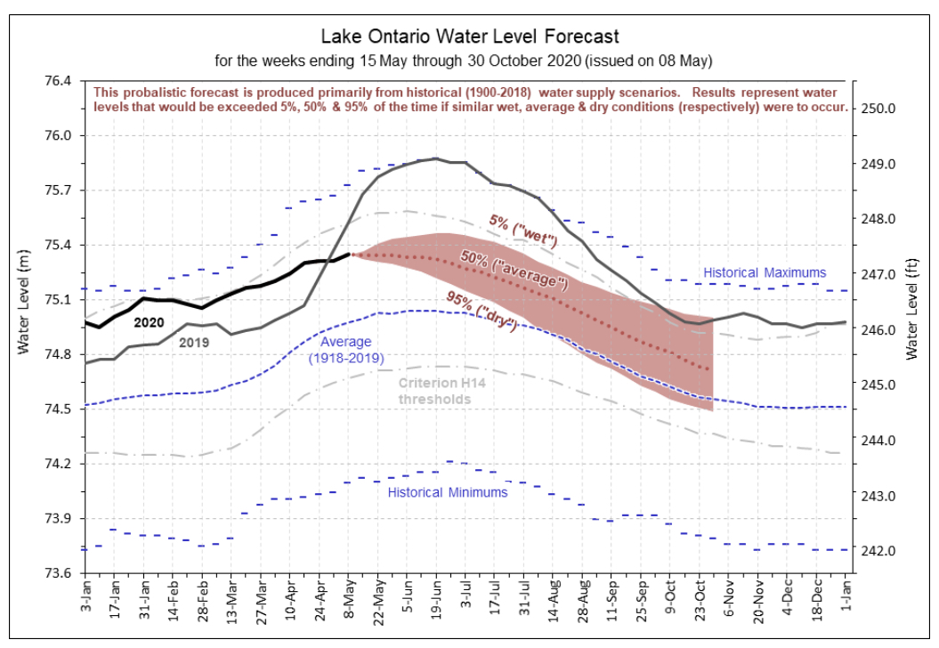
Latest IJC forecast for Lake Ontario.
Also bored out my mind so learned how to use iMovie")
Also bored out my mind so learned how to use iMovie
lakes mich/huron set new water level record! 13.4" above this time last year (april). "expected to get higher"
i wonder what the next 5 years will bring?
i wonder what the next 5 years will bring?
It is not like we have permanent ice in our watershed, so is the extra water due to more water in the glacier watersheds evaporating and ending up as precipitation in our basin? The apocalyptic scenarios I have watched/read always referred to rising ocean water levels as the risk so that was as far as my thinking had gone to this point.
With HIGH WATER warnings, comes low water. A friend snapped this down in our harbor during the last high water warning (last week). This was the LOW WATER side of that tide event.
That is the public boat launch in the right of the frame(floating docks, not floating).
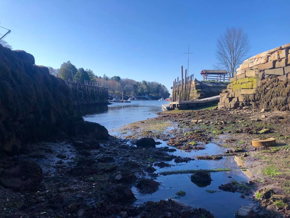
We launch near 100' long boats here. This fife schooner draws 10'.

That is the public boat launch in the right of the frame(floating docks, not floating).
We launch near 100' long boats here. This fife schooner draws 10'.
Reminds me of why we have tides.With HIGH WATER warnings, comes low water.
As the Earth rotates and the Moon orbits, there is a rotating directional gravitational pull on the Earth. Both encircling water and Earth crust, as well as the molten core, are pulled towards those gravitational forces. Since distance effects strength of the force, the nearest parts, the facing oceans, are pulled on the hardest. This makes the facing oceans move towards the force faster. It's fluidity allows it to move independently. Next is the solid earth which follows behind at a lower rate of acceleration because the force is less at the Earth's center than on it's near surface. Last is the ocean behind the the Earth. High tides occur on the backside because the water is getting to chase the Earth at an even slower rate of acceleration.
If the tidal range is greater, that would indicate a greater wobble back and forth as the rotating gravitational field moves across the Earth's surface. Is this a consequence of a few inches of ocean rise? Are the gradients in force that sensitive? Maybe we are simply going through a phase on increased harmonic wobble or the increased in Sunspot energy is pushing us around more. It's hard to imagine how melted polar ice and a few extra inches, or even feet, of ocean level would manifest thusly.
-Will (Dragonfly)
Well that got me ponderingIt is not like we have permanent ice in our watershed, so is the extra water due to more water in the glacier watersheds evaporating and ending up as precipitation in our basin? The apocalyptic scenarios I have watched/read always referred to rising ocean water levels as the risk so that was as far as my thinking had gone to this point.
I have no scientific education to support what I’m saying so bear that in mind.
No argument the glaciers are melting at a faster rate. However I assume there has always been some melting so there would already be a watercourse to carry that water.
Increased melt would increase the flow in those watercourses (more water running downhill to somewhere) but I’m not sure if that correlates to a increased amount of water being evaporated. I guess if the water ending up flooding low areas so there was a lot more surface area to evaporate from then it makes sense.
Interesting theory!
EDIT:
It’s my understanding that the rate of evaporation over the GL actually slows in summer. Sort of counterintuitive but as a typical summer day comes with high humidity the rate of uptake from the.lake slows as the air is already laden, Faster rate on a “dry” cold air day.
This is a link to an article on glacier melt in Canada with an interesting twist
Last edited:
Is this low tide you picture a really rare event?This was the LOW WATER side of that tide event.
Not particularly, but they are in stark contrast to the extreme high water events.Is this low tide you picture a really rare event?
Extreme tides happen regularly (often monthly). I don't believe there is any science indicating tidal range is changing but extreme weather events have become a factor. It's extreme tide timing to coincide with other weather events that usually brings on the extreme warnings.
The added factor is slow but steady sea-level rise over the last century. In the last few decades, the rate of sea-level rise has accelerated. That is what has many coastal communities taking progressive action to mediate the effects of erosion and flooding in our low lying areas.
It's interesting to hear about the non tidal GL high water problems. Extreme weather may be playing a part in that as well so is somewhat related to our coastal erosion problems speeding up.
That was quite a launch. Here's a serious hydraulic trailer:nice dog picture Tom
There was less than a foot of water at High Tide and the window (30 min?), was short. Imagine the drama if she got stuck in the mud?
Here she was motoring by my boat later that day.
I find myself with a little extra time in my hands these days so I thought I would dig a little deeper into how the Great Lakes water levels are measured.
How the actual measurements are taken:
The gauge station sumps are typically six feet in diameter with an 8-foot by 8-foot brick and block structure, which houses the electronic water level measuring equipment. The sumps, stilling wells have a six-inch intake pipe, with varying lengths, from 10 feet to 1,900 feet in length, in order to always be able to measure the water levels in both extreme high and extreme low levels. The intakes are valve-controlled, removing wave action, providing the ability to truly measure the accurate water level elevations. Each station operates dual shaft angle encoders, with a primary and a redundant sensor. These encoders with optical sensors are absolute, ensuring that even when the power goes out they remain on datum, storing the water level elevations in the data collection platforms (DCPs), retrievable by GOES or phone line.
The primary water level gauge used by NOAA is the MT40 series encoder manufactured by Baldwin Electronics Incorporated. The BEI� MT40 series absolute encoders have been in operation in the Great Lakes since 1994, according to Jeff Oyler of NOAA, a 44-year veteran in the field of hydraulics and hydrology. The gauge model is installed as the primary sensor in all 53 gauging stations, he said. The encoders are precisely calibrated, readings maintained to within +0.003 meters (+0.01 ft.) to the reference elevation, which is the International Great Lakes Datum of 1985 (IGLD 1985).
Perhaps surprising is the fact that the majority of the Great Lakes brick-block gauge stations are on land, with the longest intake shaft reaching nearly 2,000 feet out into Lake Erie.
Reference link
Another link with info about the entire measurement system.
 www.glerl.noaa.gov
so I thought I would dig a little deeper into how the Great Lakes water levels are measured.How the actual measurements are taken:
The gauge station sumps are typically six feet in diameter with an 8-foot by 8-foot brick and block structure, which houses the electronic water level measuring equipment. The sumps, stilling wells have a six-inch intake pipe, with varying lengths, from 10 feet to 1,900 feet in length, in order to always be able to measure the water levels in both extreme high and extreme low levels. The intakes are valve-controlled, removing wave action, providing the ability to truly measure the accurate water level elevations. Each station operates dual shaft angle encoders, with a primary and a redundant sensor. These encoders with optical sensors are absolute, ensuring that even when the power goes out they remain on datum, storing the water level elevations in the data collection platforms (DCPs), retrievable by GOES or phone line.
The primary water level gauge used by NOAA is the MT40 series encoder manufactured by Baldwin Electronics Incorporated. The BEI� MT40 series absolute encoders have been in operation in the Great Lakes since 1994, according to Jeff Oyler of NOAA, a 44-year veteran in the field of hydraulics and hydrology. The gauge model is installed as the primary sensor in all 53 gauging stations, he said. The encoders are precisely calibrated, readings maintained to within +0.003 meters (+0.01 ft.) to the reference elevation, which is the International Great Lakes Datum of 1985 (IGLD 1985).
Perhaps surprising is the fact that the majority of the Great Lakes brick-block gauge stations are on land, with the longest intake shaft reaching nearly 2,000 feet out into Lake Erie.
Reference link
Another link with info about the entire measurement system.
Water Levels: NOAA Great Lakes Environmental Research Laboratory
Information from NOAA-GLERL
