An Anchoring Visual Guide for Chartplotters

Feb 10, 2004
3,918
Hunter 40.5 Warwick, RI
I am at anchor in Vinyard Haven on Martha's Vineyard, MA. It is blowing hard and I seem to be anchored securely. The operative word is "seem".

So as the tide rises and falls and the wind changes direction, how can you look at your chartplotter (which I leave on all the time) and tell if you are still securely anchored? Less depth and your anchor plot will get larger. Wind or current can push you across the circle to the opposite side.

Here is my present chartplotter screen-
2019_0821_145812.JPG


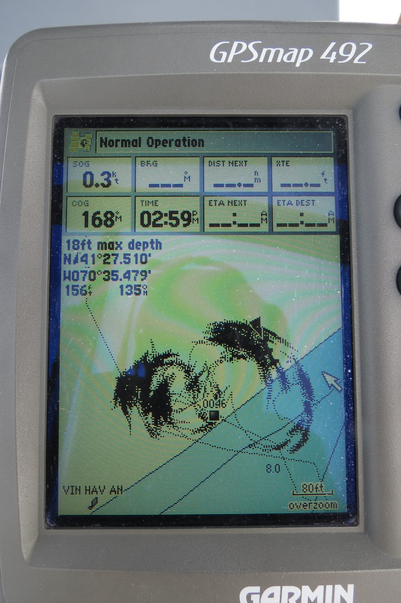
I have been here through multiple tide changes and wind and current changes.

The black wedge shape about 1 o'clock marks my current position. Have I been anchored securely? Am I still secure or have I dragged?

It can be hard to tell. How about trying to figure this question at 0100 after the wind picked up to 25+ kts?

So I created a visual aid. It is a piece of light window glass vinyl that has been printed with concentric circles. Like this-
2019_0821_150024.JPG


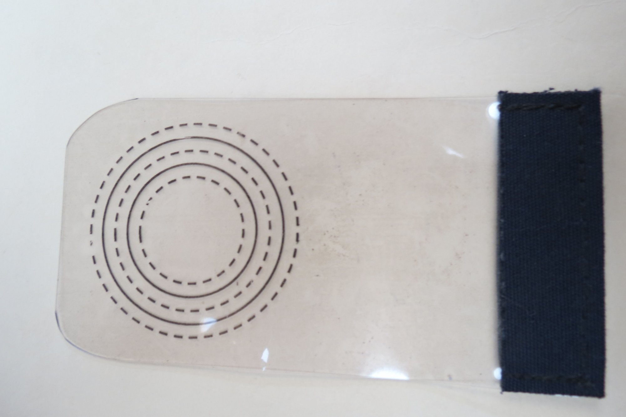
I sewed a piece of Sunbrella to the edge for easy holding. Now to answer the important question of being secure or dragging, I just hold this against my chartplotter screen and see if I can align the partial circle segments to the same concentric circle. It helps if you have placed a mark on the screen where you dropped the anchor, but that is not mandatory.

So now I see the following-

2019_0821_145850.JPG


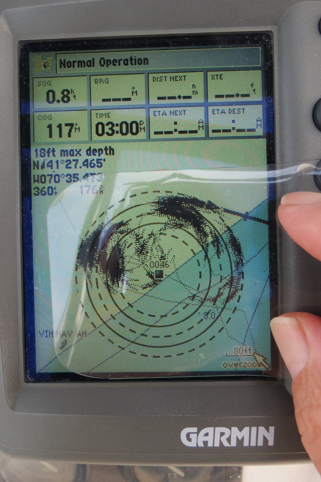
You can adjust the chartplotter scale so that your circle segments are within the range of the concentric circles.

Above, clearly I am within the outer-most circle proving that I am still secure with my anchor holding. Quick and easy. Even at 0100 in the pouring rain.

I've been using this aid for several years and given copies to a couple of my sailing friends.

This ends my Show-and-Tell.
 

TomY

Alden Forum Moderator
Jun 22, 2004
2,758
Alden 38' Challenger yawl Rockport Harbor
Nice tool! I use a GPS CP, 24/7, to keep track of the anchor. Once you've done it for a while, the signs of dragging, wind shifts, tidal change, are easy to spot.

When an anchor drags, it can show in a step that wasn't tidal. More importantly, it will trace a 'falling leaf' pattern while an anchor is dragging. I had that happen a few years ago when I drop the anchor on ledge on an island off Portland Me, at night.

It started to trace a small increment of growing arcs in the darkness. I could tell something was moving, just a foot at a time. Then those arcs began to grow! I bolted topsides and started the engine.

Great tool, thanks.

I recall this one showed a big-sudden wind increase. I use the white pointer to mark anchor location (at drop- plus set length), and to measure distances.

Anchor track.jpg
 
Jan 22, 2008
8,050
Beneteau 323 Annapolis MD
The Raymarne has a "track" function. When anchored, hit the start-track


The Raymarine has a "track" function. Once anchored, put the start track button and it will leave a line where the boat has gone. Like leaving breadcrumbs. you might swing in an arc, but should not go too far backwards as it might indicate anchor drag.
 
May 7, 2012
1,338
Hunter e33 Maple Bay, BC
Any particular reason why you would choose a chartplotter/MFD over a mobile device to carryout the anchor watch/alarm duties? I’m just thinking of the difference in power consumption when off the grid.
 
Jun 14, 2010
2,081
Robertson & Caine 2017 Leopard 40 CT
Any particular reason why you would choose a chartplotter/MFD over a mobile device to carryout the anchor watch/alarm duties? I’m just thinking of the difference in power consumption when off the grid.
More information
 
Feb 10, 2004
3,918
Hunter 40.5 Warwick, RI
Any particular reason why you would choose a chartplotter/MFD over a mobile device to carryout the anchor watch/alarm duties? I’m just thinking of the difference in power consumption when off the grid.
First I have the chartplotter and in track mode it shows where I have been so I can see the arc.
Second, if you take your mobile ashore, the the internal GPS of the mobile will show you are somewhere on Main St. instead of on the anchor circle.
 
Feb 14, 2014
7,399
Hunter 430 Waveland, MS
I use my "Anchor Alarm" and calculate my radius of swing and add tidal changes +10%. This gives me a "Zone of Assurance".
Same as your overlay, which is way cool way too.:plus:

But the Admiral doesn't trust our Raymarine GPS Alarm.

So she has her iPad App for Additional GPS and alarm too.
______
the the internal GPS of the mobile will show you are somewhere on Main St. instead of on the anchor circle.
Hmmm? I will verify her app to double check that, but so far the iPad and Raymarine are the same GPS.

_______
Here is what is funny...

The Admiral forgets to stop her iPad alarm , since in am at the Helm, I don't.

She takes Anchor duty [her choice] and always....

BEEEEEEEPPPP BEEEEEP .... [LOUD enough for the neighbors to hear]

and it is below, in the back cabin where she left her iPad....:laugh:

Jim...
 
  • Like
Likes: jssailem
Feb 14, 2014
7,399
Hunter 430 Waveland, MS
No video, but my Raymarine does all of the above and even puts it on an iPad, cellphone and now the Admirals iWatch [alerts].

Using my radar and MARPA, it has collision avoidance and plots the course and speed relative to the object.

This done automatically, if the Radar "Guard Zone" alarm is activated.[moving anchor alarm kinda]

If in Autopilot, I can even use my Remote AP control to change course rapidly, while taking control of the Helm.

Once we were on a AP course tracking and below for about 10 minutes. Along came a high speed power boat, that triggered the radar alarm and was on a collision course.:yikes:

I pushed one button, when I got to the helm, then our boat went into auto course avoidance.
Here, as always, the other boat can't make a similar change that continues to NOT avoid a collision.

But it does react quickly, but it does take an Alert Captain to override, if necessary.
____
It took me a good while to learn these Features, but once I did, it reminded me of my Days, as back seat in flight training.

The stuff that is now available for Boat Safety, was a Military secret, 15 years ago.;)
Jim...
 
  • Like
Likes: jssailem
May 7, 2012
1,338
Hunter e33 Maple Bay, BC
More information
I don’t have any data to back it up, but I would estimate that an iPad consumes 1/3rd or less of the daily power that a MFD would. A mobile phone, maybe less than that. The specs show that my Raymarine e95 would consume about 30Ah per day. My daily usage is between 55 and 70Ah.
First I have the chartplotter and in track mode it shows where I have been so I can see the arc.
Second, if you take your mobile ashore, the the internal GPS of the mobile will show you are somewhere on Main St. instead of on the anchor circle.
There are various anchor apps to choose from. The one I use is called simply “Anchor”. It does track the movement of the boat to a settable distance (5’ increments) or continuous.
Also you can raise the anchor if you go ashore with the device, lower the anchor on your return and then click on the app’s “Revert to the previous anchor position” icon. Ops Normal.
I have a 175W solar panel but no generator. Maybe I am a little anal about conserving power.
 

TomY

Alden Forum Moderator
Jun 22, 2004
2,758
Alden 38' Challenger yawl Rockport Harbor
More information
My antique Garmin uses 4 watts (black and white). Considerable but I've found having this anchor sentry on 24/7 is important to me, as well as a convenient clock. The constant tracing gives wind, tide and swing info on our anchor at a glance day or night. A phone is a nice remote anchor watch in your berth but not likely to have traced the detailed info of the boats movement. I remember many nights with a hockey puck compass or trying to get a bearing on distant lights. This is way better for me. :)
 
May 7, 2012
1,338
Hunter e33 Maple Bay, BC
My antique Garmin uses 4 watts (black and white). Considerable but I've found having this anchor sentry on 24/7 is important to me, as well as a convenient clock. The constant tracing gives wind, tide and swing info on our anchor at a glance day or night. A phone is a nice remote anchor watch in your berth but not likely to have traced the detailed info of the boats movement. I remember many nights with a hockey puck compass or trying to get a bearing on distant lights. This is way better for me. :)
This is after just a few hours. The circle is where I have the anchor alarm set for. Unlike a chartplotter, the app is pretty coarse not providing much detail.
49E3DF59-D864-422A-B453-97BEF29F68CF.png
 
  • Like
Likes: Bob S