
I-Pad Chartplotter
- Thread starter Ducati
- Start date
- Status
- Not open for further replies.

Great idea! In this morning's Doonesbury comic the wife hears her husband going on about all the features of the now I-Pad. "It makes perfect Panini's! too", he crows.

You might not even need to plug in that GPS, looks like it has it built in......
GPS and navigation features:
Built- in GPS chip and accelerometer.
Built-in magnetic compass.
Apple claims the iPad will run all existing iPhone apps, including navigation apps. However, the screen size will remain iPhone-size until developers adapt their apps for the larger screen.
Google Maps runs full-screen on this device, which makes it more like the Google Maps experience on a good PC or laptop monitor
Since I work in IT, I may need to pick one up to do some "research"
GPS and navigation features:
Built- in GPS chip and accelerometer.
Built-in magnetic compass.
Apple claims the iPad will run all existing iPhone apps, including navigation apps. However, the screen size will remain iPhone-size until developers adapt their apps for the larger screen.
Google Maps runs full-screen on this device, which makes it more like the Google Maps experience on a good PC or laptop monitor
Since I work in IT, I may need to pick one up to do some "research"


I have been using tablet PC's now for about five years every day for my job and I can assure you they are NOT water proof nor visible in the day light. Even in my car on a bright day the screens are hard to see. I can't imagine that the iPad has a daylight vis screen and is waterproof. You can buy a waterproof daylight vis plotter for less..To bad its about as water proof as a paper towel
I wonder if someone can tell me the advantages that justify the expense of a chartplotter over a computer. Many people have plotters, so I assume their cost is justified. In evaluating this, I want to make sure I understand the pros and cons.
I understand plotters are largely waterproof and may interface better with other sensors to combine several functions, such as wind direction and depth readings. I'm sure there is a great deal more.
As to the Ipad versus the computer wonder if the Ipad is more water or vibration resistant than a 12" notebook. What other advantages does the Ipad present over a small notebook computer? Is the screen more visible in sunlight or an angles? Does it interface more effectively with gps than a pc does?
I understand plotters are largely waterproof and may interface better with other sensors to combine several functions, such as wind direction and depth readings. I'm sure there is a great deal more.
As to the Ipad versus the computer wonder if the Ipad is more water or vibration resistant than a 12" notebook. What other advantages does the Ipad present over a small notebook computer? Is the screen more visible in sunlight or an angles? Does it interface more effectively with gps than a pc does?


I've been using my Acer Netbook as a chartplotter for some time now. Load in the charts, run your favourite Nav program (unfortunately in Canada it pretty much has to be Maptech if you want to see your BSB4 charts ), plug in a cheap GPS and voila!
Advantages over "conventional" chartplotter:
1. CHEAPER
2. bigger screen
3. you can play solitaire on it at the same time (or if you have a cellphone digital "stick", surf the web)
4. (If you use a real llaptop rather than a netbook) you can also use it for watching DVD movies.
Disadvantages over conventional chartplotter
1. seriously not waterproof
2. VERY hard to see in sunlight
3. more wires, gadgets, boxes, etc.
I use my "chartplotter" GPS usually to display speed and course over ground, dist and bearing to waypoint, and battery voltage in NICE BIG LETTERS that my old eyes can see from anywhere in the cockpit.
druid
), plug in a cheap GPS and voila!Advantages over "conventional" chartplotter:
1. CHEAPER
2. bigger screen
3. you can play solitaire on it at the same time (or if you have a cellphone digital "stick", surf the web)
4. (If you use a real llaptop rather than a netbook) you can also use it for watching DVD movies.
Disadvantages over conventional chartplotter
1. seriously not waterproof
2. VERY hard to see in sunlight
3. more wires, gadgets, boxes, etc.
I use my "chartplotter" GPS usually to display speed and course over ground, dist and bearing to waypoint, and battery voltage in NICE BIG LETTERS that my old eyes can see from anywhere in the cockpit.
druid

I wonder if someone can tell me the advantages that justify the expense of a chartplotter over a computer. Many people have plotters, so I assume their cost is justified. In evaluating this, I want to make sure I understand the pros and cons.
I understand plotters are largely waterproof and may interface better with other sensors to combine several functions, such as wind direction and depth readings. I'm sure there is a great deal more.
Depends on where you sail. When I was on Lake Ontario, never needed one. Motored out of the marina and sailed away for hours with no worries.
Now, I wouldn't think of going anywhere without it. Red buoy almost off the port, green buoy upper left, green buoy mid right, and the light blue is rock beneath the surface that is not visible. The area ahead is clear wide open water. Wind typically is from the west, which makes sailing through this area fun at the least. It can be done from charts or computer at the nav table, but I like to push as far as I can get and its not fun without the plotter.
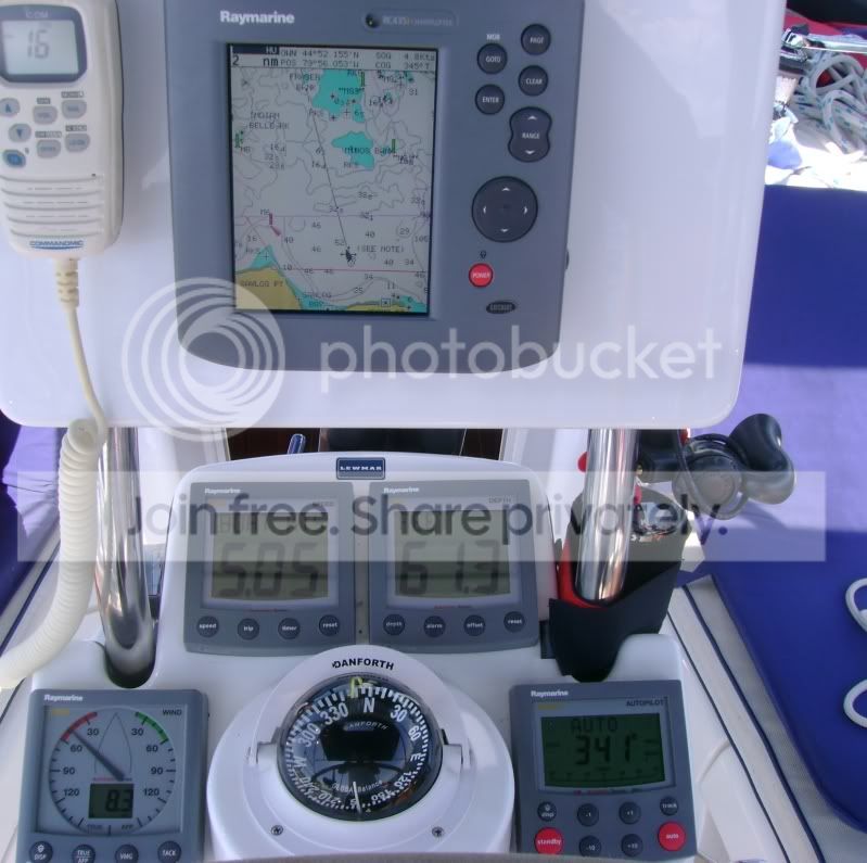

It kills me that all the marine manufacturers use proprietary networks. It would be wonderful if they made components that spoke through a usb-based network--or better yet, a wi-fi wireless network. Computers are destined to replace the plethora of instruments that are currently out there. The computer can live down below and display the data to multiple touch screens around the boat. Mil-spec displays will be able to withstand the weather.

I'd point out, that in favor of the iPad is its relatively long battery life and the fact that the Navionics navigation app is already out there... However, I think most boaters would be far better off with a small chartplotter rather than using the iPad. The chartplotter would be a single use, less prone to failure and waterproof device that would cost less than the iPad.
BTW, only the more expensive "WiFi + 3G" model of the iPad has an integrated GPS IIRC. So, if you don't want to add a bluetooth GPS to the budget, you're looking at $599-699, not $499...which is for the WiFi only model with no GPS.
BTW, only the more expensive "WiFi + 3G" model of the iPad has an integrated GPS IIRC. So, if you don't want to add a bluetooth GPS to the budget, you're looking at $599-699, not $499...which is for the WiFi only model with no GPS.
Agreed on the problem we've had with proprietary systems, but am heartened in my current research of upgrading autopilot, GPS, and several other instruments that the adoption of NMEA 2000 standards by most of the big manufacturers in 2007 is allowing much simpler, "open architecture," "best of breed" systems. For example, I can mix a Simrad autopilot with a Garmin GPS and Raymarine MFD as well as my flat screen TV and tie in a new Furuno digital radar and the engine instruments for my new Yanmar (sore subject) and they can work with each other reasonably well over a NMEA 2000 wiring backbone. Not quite USB, but getting there.
- Status
- Not open for further replies.