Set your watch back 20 years
- Thread starter Tiffany
- Start date
I go sailing to enjoy "sailing" and see the scenery. Not to play with electronics.
Garmin GPSMAP 2006C and Autohelm ST4000+ is the limit of my electronics (beyond radio and the basics). Tells me everything I could possibly want to know and they are NOT linked. That's what gets you into BIG BIG trouble.
Stuck in the past ? Nope. Just not a sucker for useless electronic gadgets and I really do enjoy sailing.
Garmin GPSMAP 76Cx and Autohelm ST3000 is the limit of my electronics (beyond radio and the basics). Tells me everything I could possibly want to know and they are NOT linked. That's what gets you into BIG BIG trouble.
Great minds think alike.
That setup got me from San Francisco to British Columbia. "Gee, sir, they said with tears in their eyes, How could you possibly go that far with such inferior instrumentation?!?" "I am a sailor, not a gadget geek," I replied.
Great minds think alike.
That setup got me from San Francisco to British Columbia. "Gee, sir, they said with tears in their eyes, How could you possibly go that far with such inferior instrumentation?!?" "I am a sailor, not a gadget geek," I replied.
Now that you mention it, that pretty well describes most of the people I see in our marina who are well loaded with electronics."I am a sailor, not a gadget geek," I replied.
Last year we had a guy in a 40'+ gin mill plow into one of the pilings of our Second Narrows Bridge. The piling is the size of a tall building.
I wonder if that was his problem.
Couldn't be, naw...I'm sure the Second Narrows Bridge piling just jumped out and bit him!!!I wonder if that was his problem.

He will, of course, tell his insurance company that it was an autopilot failure.
20 years? A good many of us started sailing pre-GPS. Try 40 years ago or more.The world is complicated, sailing shouldn’t be... With all the new tech available today is sailing getting better or just more complicated?
Was boating better in the nostalgic "good ol' days"?
GPS is like cheating. Many days I leave it off, not like I'm going to get lost anywhere with a day of home. I always liked paper charts and looking for landmarks. But I'll keep GPS as an improvement for trips, and it is nice for documenting double-diet speeds. But a $5000 plotter seems absurd. I was thrilled when we got lon/lat.
Autopilots can really relieve the tyranny of the tiller, making longer trip so much more practical for singlehanders. Running off a wind sensor is nice, but just magnetic is enough. Yes, there were wind vanes, but they have always been fussy and impractical for many things. I certainly wouldn't call them simple.
Depth sounders are pretty nice. How vital depends on where you sail, draft, and coastal piloting skills. I don't use it much, but I sail familiar waters and the bottom is sand or mud. My first two boats had no sounder, and I circumnavigated the Delmarva with one of the them, including running the entire Virginia Inside Passage, which is a lot of shallow water. I watched the chart and ATNs. I'm not even sure GPS would have helped that much, since much of the charting was old and things move. You really sensed the depth mostly by really looking at color and waves, and getting a feel for where sand deposits. You had to think your way through it. And mostly I was running too fast for a depth sounder to save you.
---
I would be OK with going back to nothing electrical for day sailing at least. Kind of nice. In fact, often I don't turn any of it on. I've known people to cancel even short cruises when their nav suite or autopilot went out. Silly. Embarrassing, actually.
Last edited:
I don't know if that will cut it.He will, of course, tell his insurance company that it was an autopilot failure.
I bet he lost the whole thing as no doubt his insurance was denied for not having any competency certification. Power boaters never bother with Canadian PCOC.
If so, do they realize they may not have liability insurance ............or any insurance for that matter. Not good for people in Canada without a simple PCOC.

The instrumentation he needed was the highly advanced mark III eyeball. It's actually quite amazing.Now that you mention it, that pretty well describes most of the people I see in our marina who are well loaded with electronics.
Last year we had a guy in a 40'+ gin mill plow into one of the pilings of our Second Narrows Bridge. The piling is the size of a tall building.
I wonder if that was his problem.
I'm not going to say I've never hit anything, only that I know who's fault it was.
 I didn't use the mark III eyeball.
But when they started linking the GPS to the autopilot, that was the cause of many, MANY crashes around here. In the incident below, one of the descriptions in the Vancouver news was that the Tollycraft suddenly turned in front of the ferry and maintained its course to the very bitter end.But I'll keep GPS as an improvement for trips,
Sure sounds like his GPS obeyed instructions of a predetermined route and ordered the autohelm to turn at that particular lat./long. Unfortunately, the route did not show a ferry would be in their course at that particular location.
Breakfast was great until the damn BC Ferry showed up.
While I may have some of the new tech on my boat (chartplotters, AIS), I still practice and enjoy the fine art of sailing. There's nothing wrong with the Mk 1 Mod 0 eyeball! 
jssailem
SBO Weather and Forecasting Forum Jim & John
- Oct 22, 2014
- 24,464
SAILING can be enjoyed as a sensory experience.
The challenge for many sailors is that they have not learned or trained their senses to provide the information they seek. For sailors who lack sensory skills, technology offers precision and accuracy sensors that exceed the human body's. While this level of performance may be necessary in a competitive environment, giving a racing skipper the edge, it is more data than necessary and often, if not filtered, distracts rather than enriches the experience.
For example, the Beaufort wind chart, such as this NOAA version reprinted here, can provide an adequate understanding of the sailing conditions for most non-racing experiences. Practicing looking at the sea state can provide the needed information regarding the time to reef (i.e Beaufort 3-4).
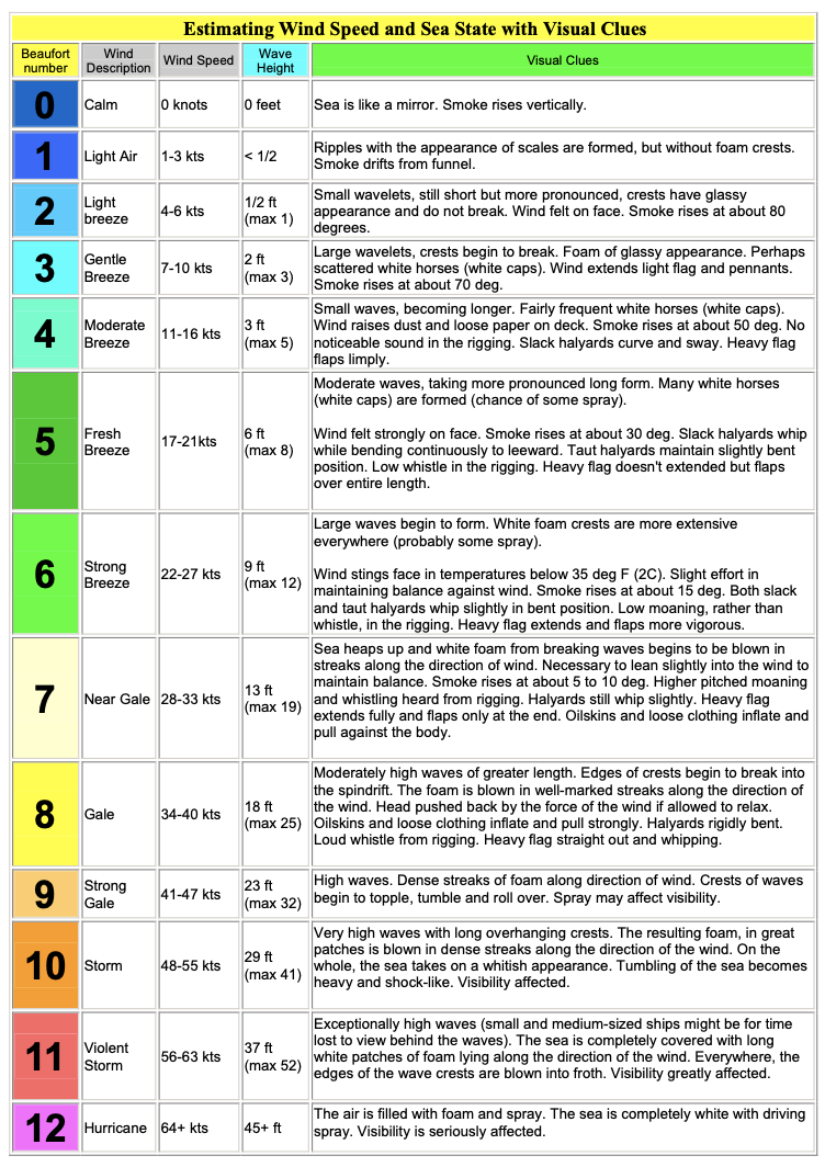
Do you really need to know the wind is blowing 13.2 mph, 270º magnetic or can you feel the breeze on your cheek or neck hairs and know when you need to tack and how to trim your sails.
Sure this comes with experience. Yet, it is a skill you can learn if you get out on the water and practice. Getting your eyes off of the cockpit chart plotter and scanning the water is the key. Who knows maybe you'll see that crab pot hidiing just off the bow, waiting to snag your rudder. Sitting there feeling smug because the crab pot knows it can not be seen on the chart plortter.
The challenge for many sailors is that they have not learned or trained their senses to provide the information they seek. For sailors who lack sensory skills, technology offers precision and accuracy sensors that exceed the human body's. While this level of performance may be necessary in a competitive environment, giving a racing skipper the edge, it is more data than necessary and often, if not filtered, distracts rather than enriches the experience.
For example, the Beaufort wind chart, such as this NOAA version reprinted here, can provide an adequate understanding of the sailing conditions for most non-racing experiences. Practicing looking at the sea state can provide the needed information regarding the time to reef (i.e Beaufort 3-4).
Do you really need to know the wind is blowing 13.2 mph, 270º magnetic or can you feel the breeze on your cheek or neck hairs and know when you need to tack and how to trim your sails.
Sure this comes with experience. Yet, it is a skill you can learn if you get out on the water and practice. Getting your eyes off of the cockpit chart plotter and scanning the water is the key. Who knows maybe you'll see that crab pot hidiing just off the bow, waiting to snag your rudder. Sitting there feeling smug because the crab pot knows it can not be seen on the chart plortter.
We have a depth sounder (there are some shallow reefs where we day sail and I draft 6'). That's about it -- navionics on a cell phone just to see how much farther toward shore we can go, but we don't use it that often. And a manual wind vane. Though I would love to have an electronic one so I can sail with the bimini up (it's 90 deg F here right now, and we're used to 70s) and still have an idea of where the wind is -- hills on both sides of the lake we sail in, so it can move around quite a bit. Once out into open water, it's not that big of a deal.
The first cruise I took on my brand spanking new Tanzer 22 was across Lake Ontario, about 50nm. We were well equipped with a boom box, compass, and charts, real paper charts. Forty years later, we're pretty well teched out, chart-plotter, AP, Radar, AIS, StarLink. And for some those we have backups, just incase one of the 7 gps's fail.
We have all of that equipment because we're out cruising and it remarkably helpful in spotting marks, watching for shoals, and communicating with other boats, especially the really big ones, like this one passing us just outside of the Eisenhower Lock on the St Lawrence Seaway. AIS is also a great entertainment source, you can see where boats are going and coming, whether you're gaining or losing on the boat ahead of you, and as a way to make social connections at the dock.
While I have the ability to do so, I never set a route in the chart-plotter and never set the AP to follow a route. Except in open waters, the AP's steering is vigilantly monitored and frequently corrected. The AP steers because it is less prone to distractions than the skipper and it is less tiring on long passages.
The question isn't technology or not, it is the technology you need and how the technology is used. The technology we have and use, helps us to be safe and saves us the time it would take to plot courses and calculate distances.
Novice sailors will be better sailors if they learn without the all the gee whiz technology. The biggest drawback to tech is the tendency for it to keep eyeballs in the boat and not out on the water where they belong. Those big Nav pods with all the information 2 feet away are an abomination, they are a huge distraction and make it difficult to shift gaze, from the water and back.
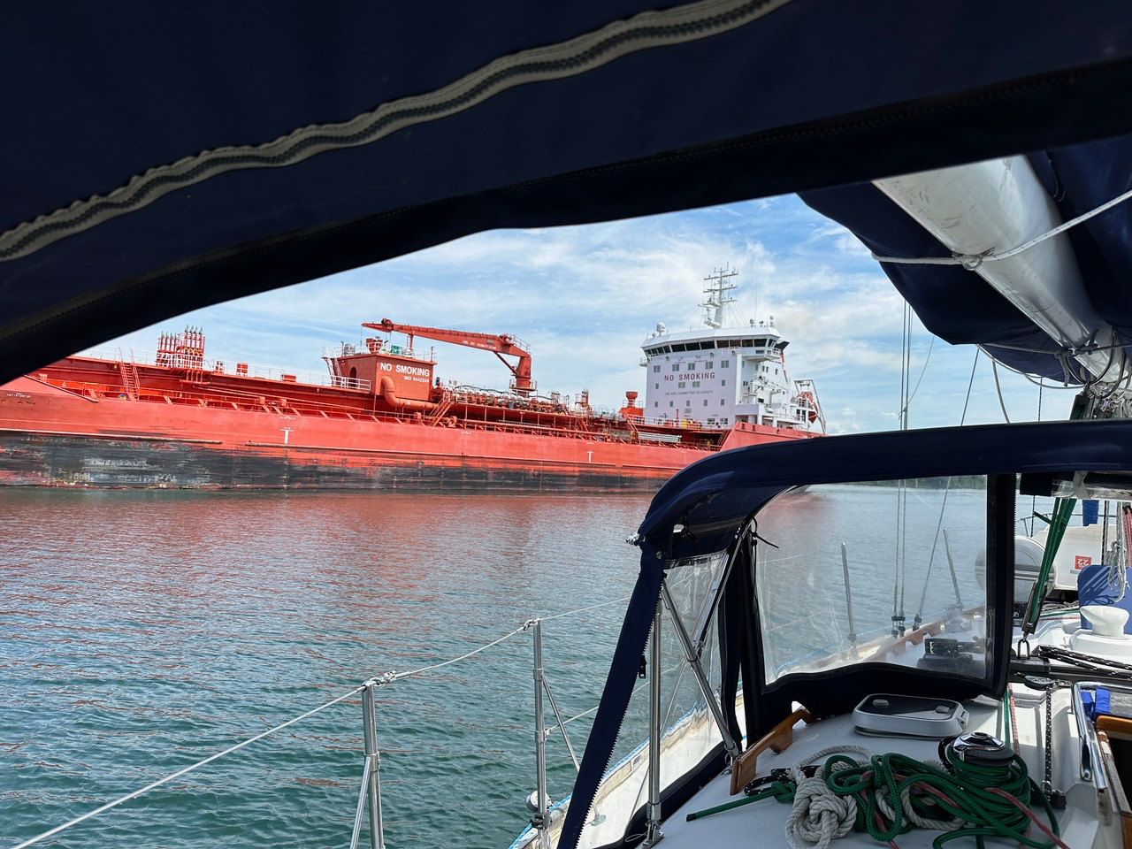
This article just shows up in my news feed. What caught my eye was the fifth paragraph:

 www.oswegocountybusiness.com
The Sooner State power couple docked their yacht — equipped with radar, sonar, automatic identification system (AIS), VHF radio, GPS, fish finder and chart plotter — in the Eastside Marina en route to the St. Lawrence River to Montreal then Quebec and Nova Scotia, Prince Edward Island and Halifax after traveling the Intercoastal Waterway from Florida.
Former Oklahoma Gov. Mary Fallin Finds Solace in the Port City
Governor and her husband, en route from Florida to Halifax, make a stop in Oswego By Tom and Jerry Caraccioli [caption id=attachment_7673 align=alignright width=450] This is the governor’s first-ever foray traveling solo after she and her husband purchased “Lady Gov” in August 2023. The yacht...
Speaking of Old School ... I was going thru a drawer lately and ran across my old Power Squadron materials. Many years ago I laminated some of the PS tables such as: 1. Tide height correction (Possibly useful in anchoring). 2) Distance of Object by Two Bearings 1 to 3. 3) Height of Tide at desired time work sheet. 4). Distance by Vertical Angle ( Useful for lighthouses, radio towers, etc.). 5) Distance of horizon. 6) Set and Drift of Current at Desired Time (Good for timing passages). 7) Velocity of Current At Any Time (East Coast). 8) Interval Between Slack and Maxi mun Current. 9) Duration of Slack.
Obviously this information is available on easier to use sources but these tables can be fun for those who like to observe natural phenomenon. Also fun on coastal cruises.
There is also a Nautical Slide Rule (Weems & Plath. USPS Star finder with all the acetate inserts a USPS LHAT Computer (Not electronic - more like a slide rule.).
I'm giving this away for postage to anyone who might enjoy. It's very unlikely I'll use them again and my descendants would just throw them away not knowing what they are.
For Chrissake, there's an accident madly looking for a place to happen.What caught my eye was the fifth paragraph:
Oh, for a second Chrissake, what is this guy, a lap dog ? Yes dear, no dear, right away dear, three bags full dear. Sounds like an Oklahoma Gigolo.
If anyone were to hang that title on me, I'd shoot myself today.
Well, I'm glad to see they had a fish finder installed. That's bound to get them out of any distress they may finds themselves in.
Yes dear. Very good dear.
While we have the usual electronic suite, my most electronic "toy" is the Bluetooth stereo. The volume and music can and IS selected by me at the helm... Nothing like Jimmy Buffett while sailing.. but the Pure Oldies 104.5 on Tune In always has the tunes we like...
Missed that in my first mouth foaming rant. I have one as well.my most electronic "toy" is the Bluetooth stereo.
Yes, the Bluetooth Stereo. Perfectly acceptable as it is completely detached from navigation or anything else to do with the boat.