I am newly back into sailing just purchasing a C&C 33 that we are keeping in Winthrop Harbor this season. I want to purchase waterproof charts for the Great Lakes as I intend to introduce my family to cruising and also need to transport the boat from Lake St. Claire to our home port. Can anyone recommend a good chart book? I don't want to simply rely upon GPS. Thanks-Alternate Reality
Great Lakes Navigation
- Thread starter Alternate Reality
- Start date
On Lake Ontario, there is only one, Richardson's Chart Book. You can buy a vinyl cover for it. The only waterproof chart books I've seen are pretty lame and mostly used for locating hot fishing spots.
@Alternate Reality welcome to the sailboatowners.com crew!
The idea of a waterproof chart sounds great, you can keep it at hand, at the helm in the rain. The reality is paper (waterproof or not) does not provide very good situational awareness compared to a chart plotter. Paper is great for route planning, sitting at the chart table, marking out your route or recording your track. Under way a chart plotter is far superior. I have paper charts on board, I grew up plotting and navigating on paper, tucking the charts under the cockpit cushions to keep them from blowing away. I have a set of paper charts beside me at the moment. These days I exclusively use a chart plotter under way. If you are interested in redundancy, sure, keep a copy of paper charts on board, but also download a charting app on all your mobile devices and onboard computers. I use Navionics on my phone and tablet but there are others that work just as well.
I've had the boat's batteries die on passage due to a bad alternator, the chart plotter was no good without power. On that passage we had 7 GPS handheld devices including phones, tablets, dedicated GPS. We really didn't miss the chart plotter and yes, I had the appropriate chart book on board but I never opened it.
There is a great thread here about chart plotters vs. portable devices for navigation. A lot of people are using waterproof tablets at the helm these days. I have raced on boats without dedicated chart plotters and I just kept my tablet in a heavy duty zip lock bag which kept it dry in the rain.
Your C&C33 has a good sized chart table. I'd suggest keeping the paper charts down below.

jssailem
SBO Weather and Forecasting Forum Jim & John
- Oct 22, 2014
- 24,491
You might want to investigate a membership in the Great Lakes Cruising Club. They publish harbor reports for all the Great Lakes and they are wonderful. Information on how to enter each harbor, places to anchor, marinas to dock, information about the towns, hazards and more.
They use member input to update the harbor guides.
They use member input to update the harbor guides.
Four years ago I moved from San Francisco to Vancouver Island, B.C. My son & I sailed our boat up. We used a series of ocean charts borrowed from a friend for route planning, two books (Charlie's Charts and Douglass) and a hh GPS Garmin GPSMap76Cx. Yes, the charts were helpful for long range planning but were also used to track our hourly progress up the coast. Some days were only 5 hours, some were twice as long and one was 13.The reality is paper (waterproof or not) does not provide very good situational awareness compared to a chart plotter. Paper is great for route planning, sitting at the chart table, marking out your route or recording your track. Under way a chart plotter is far superior.
When we got here and I started cruising locally in the Gulf Islands, we were reminded that our Garmin's charts were US charts and ended essentially at the US border (although there are some overlaps). They didn't cover more than half of the Southern Gulf Islands and none of the northern ones.
I bought the Canadian Chart Book 3312, Gulf Islands.
I decided that it simply didn't warrant the expense of getting electronic charts of the area I sail in now.
The chart book is excellent, and works for my purposes. This has worked just fine for the four seasons I have used this excellent chart book.
I completely disagree that "...paper (waterproof or not) does not provide very good situational awareness compared to a chart plotter..." and "...Under way a chart plotter is far superior."
Perhaps this is because I learned to sail before chartplotters were invented. My first electronic aid was a West Marine Loran, which only displayed lat/lon and I continued to use charts.
Chartplotters can only show a small area on their screens, and, of course, they are excellent in showing a great level of local detail.
Situational awareness is the responsibility of the skipper, and has nothing to do with the type or method of display.
Charts are just fine for my use.
I disagree with the sweeping generalizations made.
Exactly. When I worked as a dockmaster, folks often called on the VHF to get directions to the Marina. I couldn't legally give directions, so I usually told them to check their charts. One fellow was at an intersection of two channels, and had no idea which way to go. He said he had a chartplotter, but no paper charts. As mentioned previously here, relying solely on chartplotters is never a good idea.Chartplotters can only show a small area on their screens, and, of course, they are excellent in showing a great level of local detail.
On our first trip up the East Coast from FL to MA, we used a handheld GPS that didn't have charts, and had the paper charts open on the campanionway. My wife kept track of our position on the charts, and never missed a mark. On our last trip up the coast, we had a real live chartplotter, and the paper charts were still on the companionway. We never did trust the plotter completely.
jssailem
SBO Weather and Forecasting Forum Jim & John
- Oct 22, 2014
- 24,491
@Alternate Reality The other day I was thinking about your challenge. Seems you could get one of the free NOAA charts downloaded into your home computer. You could then print out the charts you need to cover the route you plan to sail. Staple or spiral bind your own booklet. You could use water resistant paper. Or just print up copies and keep them dry inside the boat until you need them.
A low cost chart system.
 www.noaa.gov
A low cost chart system.
Free NOAA PDF nautical charts now permanent
Charts are part of a new wave of navigational products and services
Hi @Stu Jackson - Hey, it's just one man's opinion. Anyone certainly can navigate the same way we did in the 70's, or completely with their head in the chart plotter, or anywhere in between. I like having paper charts on board, to the point of bringing a chart booklet with me when I sail on other people's boats because I know not everyone carries paper charts. My father taught Power Squadron navigation in the 70s and 80s so I had a pretty good education in coastal and DR navigation sailing on the Great Lakes and Caribbean.I disagree with the sweeping generalizations made.
When Loran was introduced I used to plot our position on TD charts because I didn't trust the TD to Lat/Long translation in the machine. I plotted positions on paper charts in the early days of GPS as well, and sometimes still do.
I stand by what I said in the statements you took exception to. Again, just my opinion based on my limited experiences.
Situational awareness has a great deal to do with the tools you use. For example, let's say someone sets you down on a boat, in the distance you see land and some buoys. You have nothing with you, just you on a boat. You have very limited information about your situation. Now they hand you a paper chart. You really have not improved your knowledge much unless you have some idea where on the chart you are, even then, you would have very low location accuracy. The next thing they hand you is a hand bearing compass. Now you have a much better chance of locating yourself on the chart, assuming you have an idea of where on the chart you are and what the landmarks and buoys you can see represent on the chart. The next thing this mysterious person hands you is a hand held GPS. Bingo, now you can place yourself on the chart within a few meters. You make a bearing line on the chart, look at your compass and start sailing towards the buoys marking the entrance to the harbour. Suddenly the wind and rain picks up, visibility drops to a few hundred meters and you are focused on your compass. You have to tuck the chart under the dodger to keep it from blowing away. After a few minutes you start wondering about current and how much leeway that howling wind is causing. The handheld GPS is showing your course doesn't match your compass heading. You better counteract your steering to compensate, but how far off track are you? That channel entrance looked pretty narrow and it was shallow on one side and a partially submerged breakwater on the other. Time to bail out, wait out this blow. But how far did you travel? How far off track are you? Better plot the lat/lon on the chart to figure out where you are now. But wait, your benefactor now hands you a chart plotter and generously fastens it to the steering pedestal. Wow, now you can very quickly see how close you were to that breakwater, better turn 50 degrees to port and head for deep water. But wait, there's more! You now have AIS enabled on your chart plotter and see there are a couple fishing boats heading back in out of this nasty weather and they are going to cut across your path, the AIS alarm sounds because the closest approach is within the 200 meters you set. Time to adjust course again. Now suddenly radar shows up in an overlay on the chart plotter. Crap, there is a 50 foot barge anchored ahead. No problem, head off to port a bit more and now you are heading for safe water. I won't get into how wind instruments can improve your sailing.
I know, I rambled a bit in that paragraph, but the point is, the right tools can greatly increase your your situational awareness and keep you up to date in real time. Paper charts won't do that. I have no problem with people that want to navigate old school, more power to them. I will use a chart plotter and have back ups in portable devices (and I will still keep my paper charts for planning ... and just in caseSituational awareness is the responsibility of the skipper, and has nothing to do with the type or method of display.
 ).
).Thank you all. I have ordered the paper charts that covers my journey and forgot to mention that I also have a Garmin onboard that I will us to plot points along the way. I just don't like relying solely upon electronics. I grew up sailing before GPS and want to go through the process of mapping out the route and figuring out daily travel times between harbors so I can book overnight moorings before transient slips are all taken. I am a big fan in redundancies, especially considering that I will be crossing the lake.
jssailem
SBO Weather and Forecasting Forum Jim & John
- Oct 22, 2014
- 24,491
Have you looked at the "OpenCPN" software on your computer? The software is free. The charts are free (NOAA raster or vector charts).
You can plot your route and modify as you need. When you are happy with the route for the day you print the one map out and everything is there at your convenience.
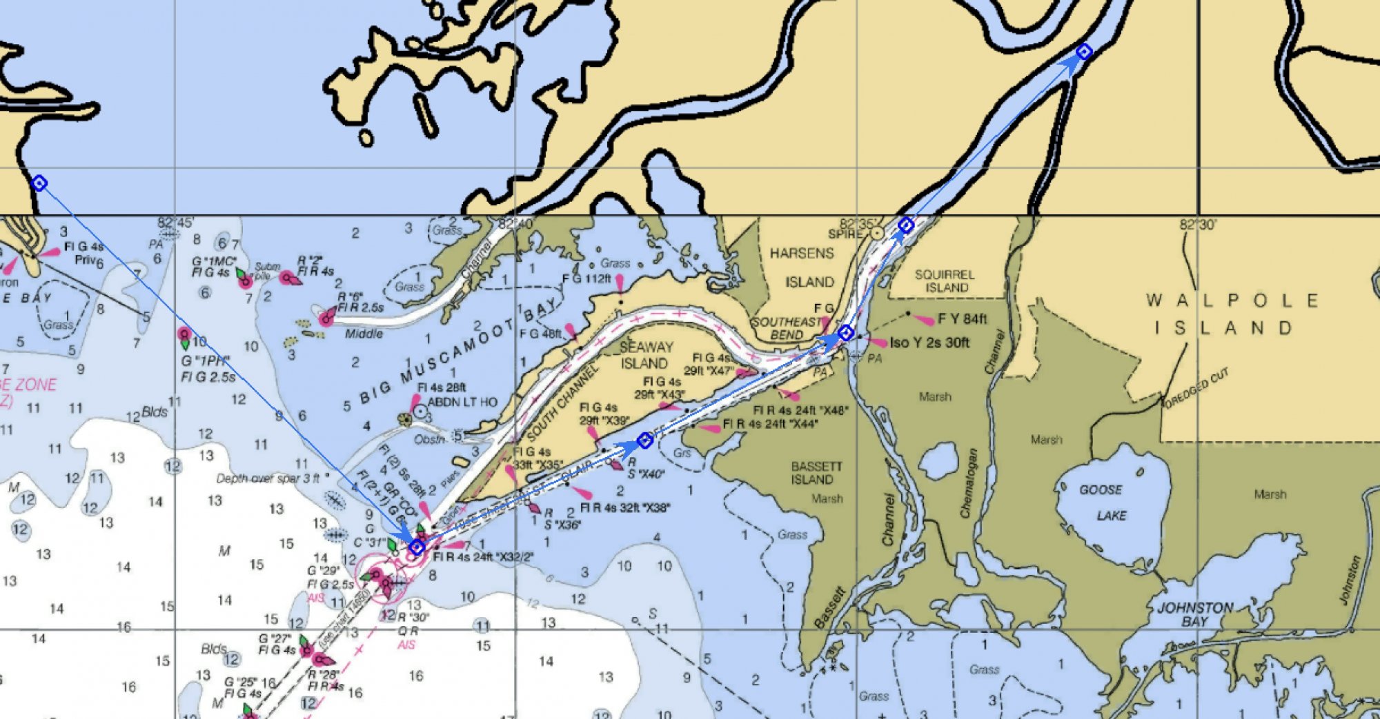
Here is a little example. Point Huron to the St Clair River connecting Lake St Clair to Lake Huron.
You can plot your route and modify as you need. When you are happy with the route for the day you print the one map out and everything is there at your convenience.
Here is a little example. Point Huron to the St Clair River connecting Lake St Clair to Lake Huron.
I often sail in shallow waters where there are no channel markers or other nav aids. I need my charts to find my way through shoals and have to keep them in the cockpit for immediate use.
To protect the charts and keep them from blowing away I went to the local plastics store and bought clear vinyl sheets and a glue that works with vinyl.
After laminating the charts I find they stay legible even in the rain and spray and don't blow around.
To protect the charts and keep them from blowing away I went to the local plastics store and bought clear vinyl sheets and a glue that works with vinyl.
After laminating the charts I find they stay legible even in the rain and spray and don't blow around.
jssailem
SBO Weather and Forecasting Forum Jim & John
- Oct 22, 2014
- 24,491
That is a good idea. @sloughsailer . I borrowed my wife's laminating equipment she used while teaching. Laminate a NOAA chart of harbors. Easy to refer to when approaching a marina.
I downloaded several NOAA pdfs for free. Printed them out large format color plotter at my wife's work in 24"x36" size. Laminated them at Fedex Kinkos for $10 a piece. Keep them in a tube. Good for planning. Works great as backup to my Zeus 2 chartplotter, Mirrored Zeus charts on Ipad and INavX on Iphone.
Last edited:
NotCook
.
- Dec 29, 2008
- 806
Zackly! When sailing offshore from the Chesapeake to Bermuda and the BVI, we plotted our position on the paper chart every watch change - just in case the power failed or the chart plotter was otherwise inop. It also made a great souvenir of the trip...planning but were also used to track our hourly progress up the coast.
Great discussion on redundancy, which is necessary if you want to make your dockings equal to your un-dockings! As they say, "on a boat, one is none". I do not like the print quality or timeliness of most chart books that I have seen, and prefer the old paper charts. Now that the US Gov't no longer prints them, they are printed under license by private printers. Here's the cheapest and best service I have found - Frugal Navigator (Official NOAA and NGA Nautical Charts). They have a good interactive web site for chart selection. I have no interest in the company, only a satisfied customer.
jssailem
SBO Weather and Forecasting Forum Jim & John
- Oct 22, 2014
- 24,491
This is one of the free PDF charts from NOAA at Chart Locator
It is the chart of the St Clair river.
You can print it as a single page, multiple page, or you can save it as a PDF file.
Many options while they still exist.
It is the chart of the St Clair river.
You can print it as a single page, multiple page, or you can save it as a PDF file.
Many options while they still exist.
Good find!Great discussion on redundancy, which is necessary if you want to make your dockings equal to your un-dockings! As they say, "on a boat, one is none". I do not like the print quality or timeliness of most chart books that I have seen, and prefer the old paper charts. Now that the US Gov't no longer prints them, they are printed under license by private printers. Here's the cheapest and best service I have found - Frugal Navigator (Official NOAA and NGA Nautical Charts). They have a good interactive web site for chart selection. I have no interest in the company, only a satisfied customer.

About $10 less than charts from Landfall Navigation.
Good point, 'cept in my case the charts were borrowed from a friend. Interestingly enough, they were used by at least one other crew who in some cases went to the same places we did, not that there are that many places TO go on that coast! I think they may have been traveling in the opposite direction, but the rhumb lines between ports of call / bar entrances were similar.It also made a great souvenir of the trip...
Had to return the charts, but I made doc files of screen shots of our track up the coast off our GPS track files. Could be even better than HUGE charts to be able to pick up an 8 1/2 x 11. True, makes for great memories.