• Sailing is all about the Weather.

    Big into the exploration of Atlantic Hurricanes since Katrina came uninvited into his world, James (Jim) Gurley (JamesG161) has followed every Tropical Storm birthed in Atlantic, Gulf and Caribbean waters since. Being a boater, he knows that we often need more time to prepare than we get from the TV weather folk. Jim relies on the science of storm development to share early warning info with friends and fellow boaters.

    Early in 2018, Jim and John Shepard, (JSSailem) started to chat about the weather data available. John asked Jim to help forecast Pacific NW storms, and this morphed into discussions on weather forecasting.

    For John, sailing in the PNW is sometimes hit and miss. One day is ugly, then a string of beautiful days but no wind, followed by a series of blue-sky days and 12 knot breezes. Being ready for those great sailing days means you need to look to the Pacific Ocean and what is brewing. John has been into Pacific NW Weather since the 1970’s when his first PNW November storm hit bringing more than 40 days and 40 nights of continual rain.

    Together we want to share information, new APPs, safety, and thoughts about letting the weather help you. Identify some of the resources for sailors and help prepare you for your next sailboat outing.

    It is far better to go out on the water knowing what to expect in weather terms, than to be out on the water and see dark ominous clouds suddenly appear, unprepared.

Hurricane Sally <--- TS Sally

Feb 14, 2014
7,399
Hunter 430 Waveland, MS
This storm is NOT tropical. It was un-used moisture tail of the South Carolina Invest 94L.

We had noted "Rain Over Miami" to follow in 4 days later.
This is that moisture. [ note: please don't steal my new song title:mad:]

The Hurricane Hunters just finished a low level flight mission.
recon_AF308-0119A-CYCLONE.png


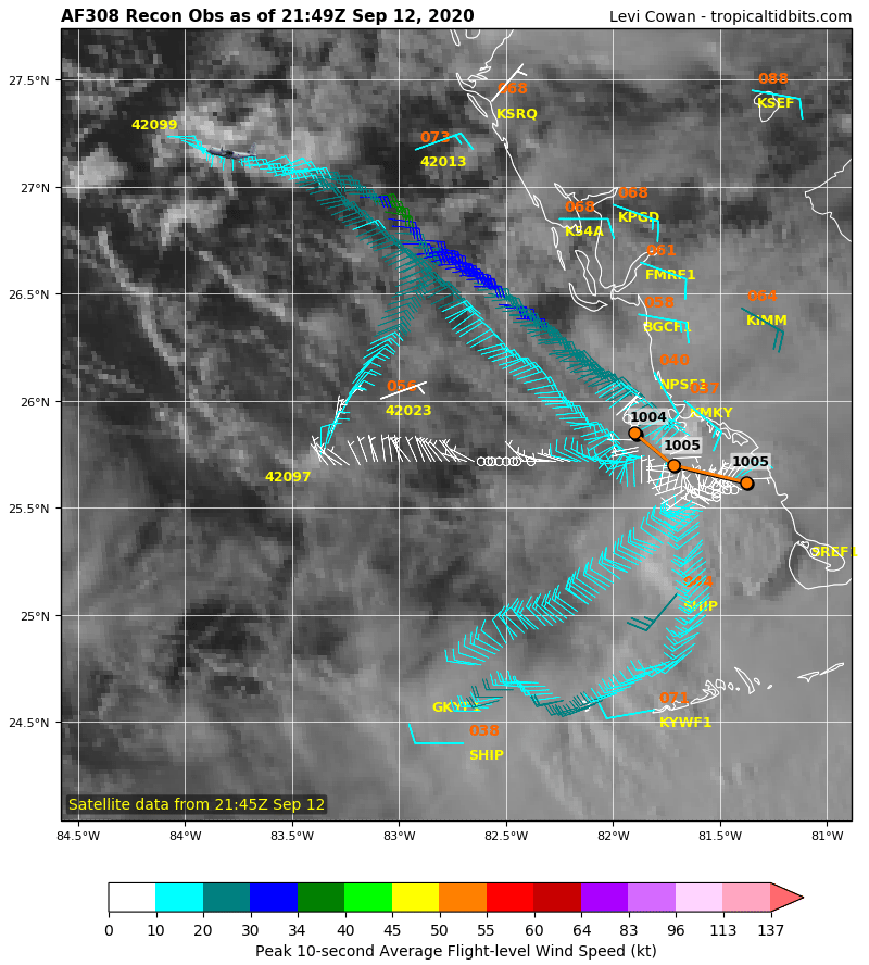
The barometric pressure is ≈1004 mbar.
I will be linking the Buoy's data later.

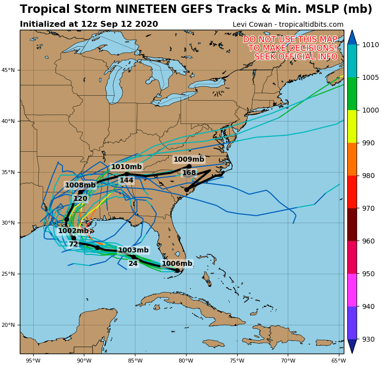
A bit early but key models say Mouth of Mississippi River on Tuesday morning 15th.

19L_gefs_latest.png


Jim...

PS: Credit Tropical Tidbits
 
Nov 6, 2006
9,884
Hunter 34 Mandeville Louisiana
Keep ya head down, Jim,. Looks like we are in for a bit of a mess.
 
Jun 21, 2004
2,532
Beneteau 343 Slidell, LA
[QUOTE Looks like we are in for a bit of a mess.
[/QUOTE]

Yes! Here we go again. Not much prep for the boat this time; canvas still off & buttoned up from threat of Laura a few weeks ago. Somewhat concerned about storm producing higher surge & rainfall because of slowing forward motion once it approaches Coast. The impact of each of these systems is different depending on wind intensity, surge, & rainfall as well path & time that it lingers. Difficult to extrapolate effects of one storm to another.
 
Last edited:
  • Like
Likes: kloudie1
Feb 14, 2014
7,399
Hunter 430 Waveland, MS
Models are trending Eastward now.

Sally.jpeg


That HIGH movement speed will determine how far East before TS Sally follows behind.

No new HHunter flight since last update.
Jim...
 
  • Like
Likes: BigEasy

HMT2

.
Mar 20, 2014
899
Hunter 31 828 Shoreacres, TX
Yes! Here we go again. Not much prep for the boat this time; canvas still off & buttoned up from threat of Laura a few weeks ago.
Just got everything back up and on, yesterday after prepping for Laura
 
Feb 14, 2014
7,399
Hunter 430 Waveland, MS
HH's found the "center" to be farther North than last flight and BP falling some to 1001 mb.

recon_AF308-0219A-SALLY-2.png


That shifted models back West again.

This is a buoy, with camera, to watch thru Sunday.
NDBC - Station 42036 Recent Data
______
The worst effect forecast for TS Sally is that is stalls out for 1.5 days as it makes the NE turn.
Huge amounts of rain and flooding low areas.

Jim...
 
Feb 14, 2014
7,399
Hunter 430 Waveland, MS
Seas and wave heights are building at that buoy...
Talk about Ominous Dark Clouds as TS Sally approaches that buoy!!

Ominous Clouds of Sally.jpeg


Rock and Roll....
_____
People here are beginning to panic. Stay Calm.

Several marinas are issuing Mandatory Evacuations along the MS coast.

At least our boat is still stripped for action, since TS Marco. We can move and tie up for a 10 foot surge in less than 2 hours.

Dammit Jim...
 
Feb 14, 2014
7,399
Hunter 430 Waveland, MS
Well I just got a mandatory marina evacuation for Monday morning.
It will take about 2 hours to move and tie up.
Here the before picture of a canal about 100 yards away.

Sally tie up.jpeg

And through the magic of Apple, the after tie up picture for tomorrow.:cool:

Sally tie up.png

Yes that is my boat to scale.:pimp:

This is a picture taken for Hurricane Nate, in that canal.
NateReady.JPG
I am allowing for a 10 foot storm surge.

Dammit Jim...
 
Feb 14, 2014
7,399
Hunter 430 Waveland, MS
Two models differ.
1) Eye passes over
2) Eye passes to the east

Tie up is easier on #2, since winds stay out of North East mainly.

Heading to boat now...

Gosh darn Jim...
 
  • Like
Likes: jssailem
Nov 30, 2016
25
Hunter 31 Madisonville
Are there any gauges or buoy's that I can monitor to see the real time storm surge in Lake Pontchartrain? My boat is kept on the noth side of the lake in Mandeville. During storms with surge I travel back and forth to marina to check and adjust dock lines to accommodate surge/flooding. By monitoring surge height I could determine when I need to go to marina to make adjustments.