• Sailing is all about the Weather.

    Big into the exploration of Atlantic Hurricanes since Katrina came uninvited into his world, James (Jim) Gurley (JamesG161) has followed every Tropical Storm birthed in Atlantic, Gulf and Caribbean waters since. Being a boater, he knows that we often need more time to prepare than we get from the TV weather folk. Jim relies on the science of storm development to share early warning info with friends and fellow boaters.

    Early in 2018, Jim and John Shepard, (JSSailem) started to chat about the weather data available. John asked Jim to help forecast Pacific NW storms, and this morphed into discussions on weather forecasting.

    For John, sailing in the PNW is sometimes hit and miss. One day is ugly, then a string of beautiful days but no wind, followed by a series of blue-sky days and 12 knot breezes. Being ready for those great sailing days means you need to look to the Pacific Ocean and what is brewing. John has been into Pacific NW Weather since the 1970’s when his first PNW November storm hit bringing more than 40 days and 40 nights of continual rain.

    Together we want to share information, new APPs, safety, and thoughts about letting the weather help you. Identify some of the resources for sailors and help prepare you for your next sailboat outing.

    It is far better to go out on the water knowing what to expect in weather terms, than to be out on the water and see dark ominous clouds suddenly appear, unprepared.

Trop Dep - 7 --> TS Fiona --> Hurricane Fiona

JamesG161

SBO Weather and Forecasting Forum Jim & John
Feb 14, 2014
7,911
Hunter 430 Waveland, MS
John and I have looked at the Science this morning.
Here is our best information now.

storm_07.gif


NOAA's forecasts it as just a Storm then back to a Depression over Haiti.
Thus low intensity from lack of HEAT fuel,

h26_aQG3_latest_natl.gif


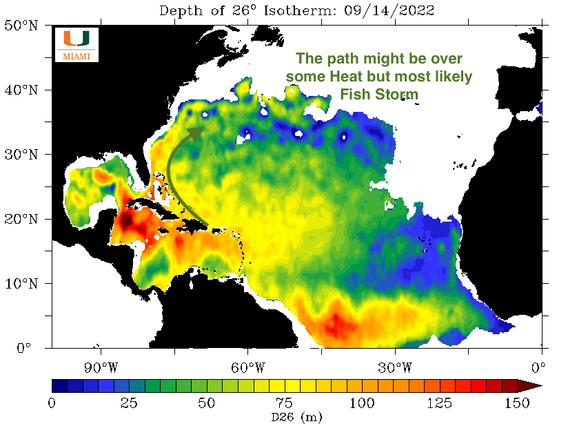
The above picture is a bit different than what we have shown before.
This the 26°C isotherm or how deep the Atlantic area Solar Energy is Stored.

Normal Heat shown next.
ohc_aQG3_latest_natl-2.gif
Note: Each of the "Training Tropical Waves" consumes HEAT. [a good thing]
_____________________
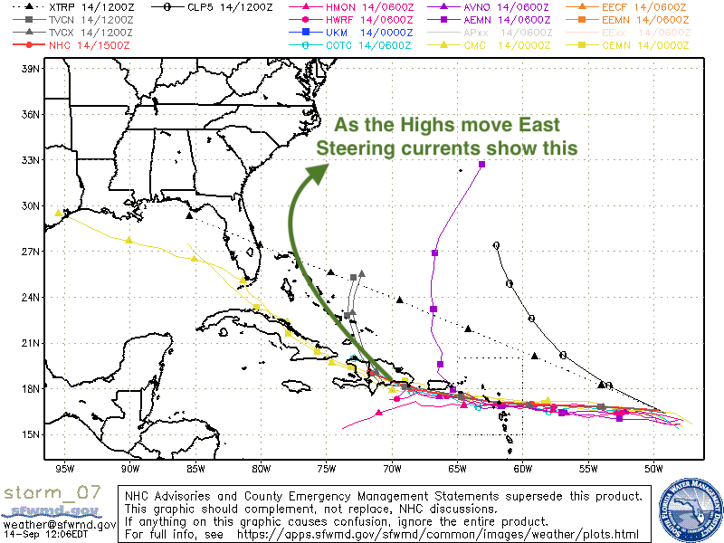
If TD 7 does not turn as both ECMWF and GFS forecast show, then we may see more discussions in about 3 days.

Otherwise our combined knowledge is shown on the pictures above for simplicity.

Jim and John
 

JamesG161

SBO Weather and Forecasting Forum Jim & John
Feb 14, 2014
7,911
Hunter 430 Waveland, MS
As we forecast, Tropical Storm Fiona will follow curves in pictures we showed above.

LOWs follow the Low pressure trough between the HIGHs.

It is the timing of those West EAST moving Highs that Models cannot accurately predict.

Easily seen now on the GFS model for the 23rd. Possibly Hurricane Fiona then.

FionaFC.png


Jim...

PS: It is the HIGH over NY state that protects the East Coast.
 
Last edited:
  • Like
Likes: kappykaplan

JamesG161

SBO Weather and Forecasting Forum Jim & John
Feb 14, 2014
7,911
Hunter 430 Waveland, MS
Pure Fluid Dynamics in action, plus the Earth's spin and a bit of Stored Solar Energy.
How simple is that? :facepalm:
Jim...
 
May 1, 2011
5,197
Pearson 37 Lusby MD
Your prediction matches what I've been seeing in local wx forecasts since last night. I'm a happy guy. Tks!
 

JamesG161

SBO Weather and Forecasting Forum Jim & John
Feb 14, 2014
7,911
Hunter 430 Waveland, MS
Your prediction matches what I've been seeing in local wx forecasts since last night.
John and I have had that Tropical Wave [Fiona] in our Radar for 2 days before this post or the 12th.
But we watch the movements of the 500 mb winds or steering winds.

Also the Hurricane Hunters are heading to TS Fiona now. That normally means intensifying is expected in the next 24 hours.

Since @jssailem have been looking long range too, we did forecast this late season trend in Mid August.
[Pats ourselves on the Back :pimp:]

I will state it again...

3 La Niñas in a annual row. Last seen in the 70's.

Jim and John
 
  • Like
Likes: jssailem

JamesG161

SBO Weather and Forecasting Forum Jim & John
Feb 14, 2014
7,911
Hunter 430 Waveland, MS
We are going to use this thread as a warm up.

Looks like Puerto Rico well gets some strong winds

recon_AF302-0407A-FIONA.png
Re

Recon Flight that finished
_______
Next is a from the National Buoy Data center and has a Camera aboard too
NDBC - Station 42060 Recent Data

This is the data from that buoy.

plot_wind_pres.php.png


Note time of that data and the Pressure is dropping.

The curve is starting now.

Jim...
 

JamesG161

SBO Weather and Forecasting Forum Jim & John
Feb 14, 2014
7,911
Hunter 430 Waveland, MS
As the change in direction or curve starts, TS Fiona slows down.

The islands are disturbing the Eye formation.
All Hurricane Hunter flights are low level, which means no really significant strengthening, yet.

I like this link for more updated weather and mariner warnings
nowCOAST™: NOAA's Web Mapping Portal to Real-Time Coastal Observations, Forecasts, and Warnings

A picture of that link info.
Screen Shot 2022-09-17 at 8.35.47 AM.png

as of now.

The blue rectangles are Map Areas [more info on the new Map Zones soon]
Jim...
 
  • Like
Likes: jssailem

JamesG161

SBO Weather and Forecasting Forum Jim & John
Feb 14, 2014
7,911
Hunter 430 Waveland, MS
The slow turn to the North West in the Heat Fueled area of the Caribbean did the Push to Hurricane Fiona.

Even the tall mountains for Hispaniola did not prevent the Eye forming.

Torrential Rains hitting Puerto Rico now.

The parts of the Bahamas and now Bermuda are in for a pounding of a Major Hurricane.

Screen Shot 2022-09-19 at 12.55.29 AM.png

I have noticed that NOAA's and Hurricane Hunters Aircraft are landing and taking off from here...

Island of Curaçao

Shorter flights now to the Caribbean Area.
Some have left Florida and landed there.

Longer times in the storm.
recon_AF306-1307A-FIONA.png

Dammit Jim...
 
  • Like
Likes: jssailem
Mar 20, 2015
3,279
C&C 30 Mk1 Winnipeg
What are you seeing with Fiona now?

I saw some twitter storm chaser reports today saying Euro and GFS models are showing pressure as 921 mb at landfall in Nova Scotia, and 124mph wind gusts with 46 foot waves on the south coast of Cape Breton.

Isn't that pressure like a cat 5 in southern latitudes?

Wow. I wish the residents luck. (the horses on sable Island will be in very serious trouble.)
 
Last edited:
  • Like
Likes: All U Get

JamesG161

SBO Weather and Forecasting Forum Jim & John
Feb 14, 2014
7,911
Hunter 430 Waveland, MS
What are you seeing with Fiona now?
Very closed central Eye.

Bermuda is experiencing 65 mph winds and lot of rain right now.

Nova Scotia and Sable Island [on the worst side of the storm] Cat 3 hit.

Screen Shot 2022-09-23 at 7.58.40 AM.png


Note the continental shelf shallows quickly and storm surge will be huge for Sable Island.

Since this very rare hit for that area, I hope and pray they stay safe.

Hurricane Fiona is now being monitored and warnings issued by the Canadian Hurricane Centre.

Listen to them now.

Dammit Jim...
 
  • Helpful
Likes: Leeward Rail

jssailem

SBO Weather and Forecasting Forum Jim & John
Oct 22, 2014
23,630
CAL 35 Cruiser #21 moored EVERETT WA
Big waves. Fall surfing along the East Coast.... 10meter wave action in Nova Scotia and Newfoundland as the storm proceeds along it's path.

Pray the rugged folk up there prepare.