Proposed Removal of USCG Navigational Aids

Dave

Forum Admin, Gen II
Staff member
Feb 1, 2023
92
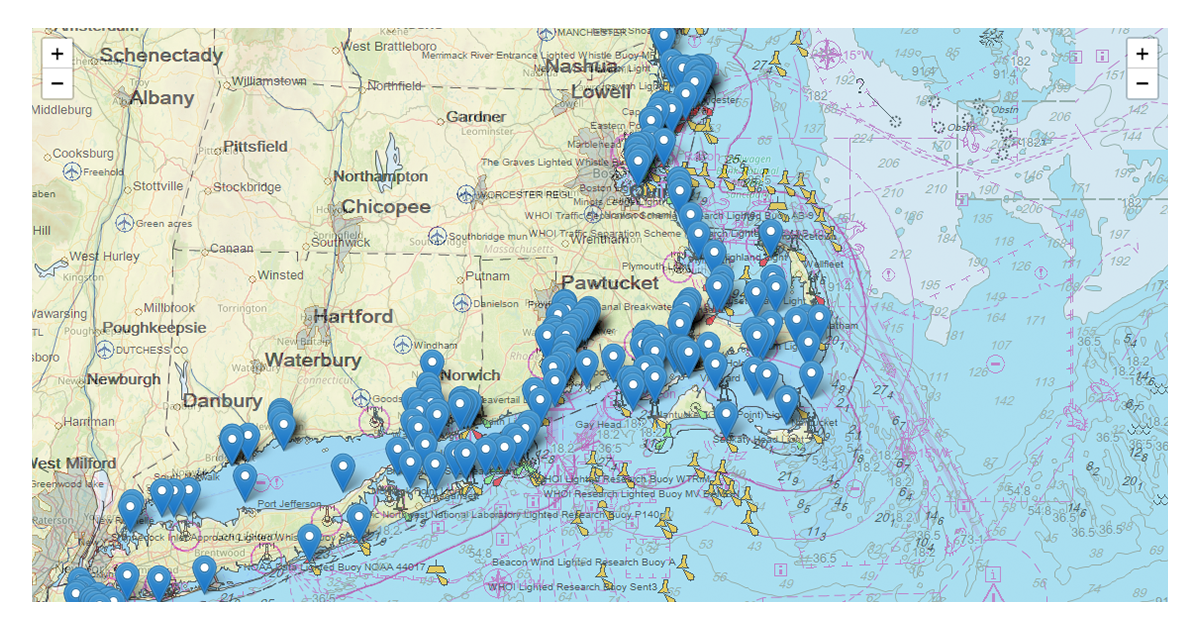
The USCG is considering the removal of a large number of navigational aids in the NE and perhaps other sectors. The link below shows the ATONs targeted for removal in District 1, Northeast US. The CG is soliciting feedback on their removal, the details are on the web page linked below.

Other CG districts may also be affected. I did not search for all possibilities. If you find your district or other districts have targeted ATONs for removal please share the links.

Finally, as a gentle reminder this is a sailing forum, not a political forum. The issue is whether some or all of the targeted ATONs should be removed and the effect on safe navigation, not the politics surrounding their removal.

 
Jun 14, 2010
2,286
Robertson & Caine 2017 Leopard 40 CT
Note they gave the following statement: "To make your comments as impactful as possible, please include the type and size of your vessel (recreational or commercial), how the aid supports your navigation, and the distance at which you typically begin to rely on it."

Email sent.
Some excerpts. Please use your own words so they don't think people are sending form letters:
Your experience and use of nav aids.

Most (if not all) of these Nav Aids were placed strategically to warn of hazards that aren’t visible to the naked eye under most conditions. Those hazards have caused considerable damage and loss to vessels or loss of life over the years to justify the placement of the Nav Aids as chart references and visual aids.

These Nav Aids are primarily used within line-of-sight conditions to verify and measure relative position, set and drift. They are critical to the safety of vessel and crew in event of a GPS malfunction or power failure aboard the vessel. Under that circumstance the relative positions of these Nav Aids would be important to navigate using manual chart references and triangulation methods with the known Lat/Long references of those aids. In many locations they are positioned near shoals in places with narrow channels and swift currents (often crosscurrents that would sweep unwary vessels onto reefs). Examples of such specific locations: (Your list)

(Specific Buoy names) These are placed where large ships and private vessels are converging close together - these buoys provide visual guidance to recreational vessels as a clear reference of demarcation to stay out of the way of the ships.)

Thank you for considering my letter in your decisions.
 
Jun 17, 2022
210
Hunter 380 Comox BC
The fact is with easy and reliable electronic charting available in the palm of our hand, visual aids to navigation don't have the true necessity that they've had in the last few hundred years. Plus with the advent of electronic ATON (place a marker with an AIS signal, anywhere, anytime), the electronic ETON will be a huge improvement in safety for all mariners, can't wait for it to start! This will allow them to instantly place hazard ATON if there's a wreck, reposition an electronic virtual buoy if a sandbank moves, etc....

Just like United can fly you coast to coast with near zero visibility by following their charts and with modern and accurate navigation systems, I don't think it's a far cry for us to do the same with our boats.

Change is tough, we have a natural tendency to resist change, but if the charts provide the information on the hazard, and we know exactly where we are on the chart, it kind of makes the ATON redundant? For the record, I sail in tidal waters mostly in BC where aids to navigation can move around laterally by 100 feet, how useful is that? I've also sailed the east coast of the US... I'd consider all the lobster trap floats a much bigger hazard to my navigation.

Canada is going big on digital ... CCG e-Nav - AIS AtoN - What is an AIS Aid to Navigation (AIS AtoN)?
 
Jun 8, 2004
1,061
C&C Frigate 36 St. Margarets Bay, Nova Scotia
The idea that visual aids to navigation can be replaced by electronic aids is the result of a specific kind of blindness - the inability to see common sense! Good old visual navigation works regardless of the state of charge of the batteries or the politics in play on earth or in space.
 
Jun 21, 2004
2,777
Beneteau 343 Slidell, LA
There is a significant number of boats that do not use electronic navigation, but rely on line of sight navigation & ATONS to safely traverse a body of water. Also reminds me of an acquaintance who was so focused on his chartplotter that he ran into a day mark! Kind of like texting & driving. Boaters need to stay focused on the water, not a screen. Electronics should be used as a supplement to visual navigation methods.
Very disappointed; the coast guard knows this and should advocate to maintain ATONS.
 
Last edited:
Jan 11, 2014
12,724
Sabre 362 113 Fair Haven, NY
The fact is with easy and reliable electronic charting available in the palm of our hand, visual aids to navigation don't have the true necessity that they've had in the last few hundred years. Plus with the advent of electronic ATON (place a marker with an AIS signal, anywhere, anytime), the electronic ETON will be a huge improvement in safety for all mariners, can't wait for it to start! This will allow them to instantly place hazard ATON if there's a wreck, reposition an electronic virtual buoy if a sandbank moves, etc....

Just like United can fly you coast to coast with near zero visibility by following their charts and with modern and accurate navigation systems, I don't think it's a far cry for us to do the same with our boats.

Change is tough, we have a natural tendency to resist change, but if the charts provide the information on the hazard, and we know exactly where we are on the chart, it kind of makes the ATON redundant? For the record, I sail in tidal waters mostly in BC where aids to navigation can move around laterally by 100 feet, how useful is that? I've also sailed the east coast of the US... I'd consider all the lobster trap floats a much bigger hazard to my navigation.

Canada is going big on digital ... CCG e-Nav - AIS AtoN - What is an AIS Aid to Navigation (AIS AtoN)?
Using ETONs exclusively, introduces a single point of failure in the navigation system. To be safe all boats will need to have multiple devices to guard agains failure. And all devices rely on the global satellite navigation systems, if those signals are degraded, accurate navigation is impossible.

There are places where ETONs make a lot of sense. Offshore buoys that align shipping channels is one that comes quickly to mind. These buoys are there to manage shipping lanes, not to warn of hazardous conditions.
 
Jun 2, 2004
3,506
Hunter 23.5 Fort Walton Yacht Club, Florida
I think there is some confusion here. Periodically the Coast Guard will opt to discontinue individual ATONs and seek public comments on whether the marks in question are actually of little use or no use.

The Aids to Navigation guys are some of the hardest working guys in the Coast Guard and do a marvelous job of maintaining the system. Mike Rowe did a segment on his Dirty Jobs TV show that is well worth watching.

The ATONs I am familiar with that have been discontinued were in areas that were seldom traveled and often vandalized or destroyed requiring repair or replacement.

If there is an ATON in your area that is being considered and of some necessity by all means respond and let the Aids to Navigation Team know how it is a valuable resource and should be maintained. Important information would be how often you pass by it, what hazard alerts you to, and how it helps you to navigate safely through the area.
 
Jun 8, 2004
1,061
C&C Frigate 36 St. Margarets Bay, Nova Scotia
I think there is some confusion here. Periodically the Coast Guard will opt to discontinue individual ATONs and seek public comments on whether the marks in question are actually of little use or no use...

The ATONs I am familiar with that have been discontinued were in areas that were seldom traveled and often vandalized or destroyed requiring repair or replacement...
I'm Canadian, so I don't really have a dog in this fight. But having sailed to Maine in the past I had a quick look and was surprised by how many 'ATONs' in the Penobscot Bay area were being slated for decommissioning.
1745503231943.png
 
Sep 24, 2018
3,275
Catalina 30 MKIII Chicago
What happens when one of these malfunctions and someone runs into the hazard? How much maintenance do these devices require?
 
Jun 2, 2004
3,506
Hunter 23.5 Fort Walton Yacht Club, Florida
What happens when one of these malfunctions and someone runs into the hazard? How much maintenance do these devices require?
Been a while but from memory.

Depends, many require minimal maintenance but must be verified. Unlit sign boards or buoys require quarterly checks to make sure first it is there, not faded, and the reflective appliques are present. If it is a lit marker, it also is checked to make sure the light is illuminating properly. In areas subject to shoaling depth is also checked to make sure it is in the appropriate location. The time required when an ATON is way up or down a river or bayou is not insignificant

Buoys are lifted periodically to clean the growth and check the anchor and chain.

The lights are really interesting the incandescing bulb type have a wheel that rotates when a bulb burns out. Most run off of a solar powered battery. They probably use LED bulbs now.

This is but one of the responsibilities of the Coast Guard. When from time-to-time other missions become more critical resources are shifted and the economy of remaining resources are deferred, reappropriated or, sometimes eliminated.
 
Apr 25, 2024
359
Fuji 32 Bellingham
So ... my question is, "Why?" Removing a nav aid is not inherently a bad idea. It depends on why it is being removed. For example, if it represents a hazard that is no longer extant, then sure, remove it. If the removal is just a cost-cutting measure, that is a different story. Also, if the removal, alone, would increase risk, then what is the plan to mitigate that risk?

I am firmly in the camp of those who make the observation that visual aids are valuable regardless of electronic failures or politics. They just work. The simple fact that they are low-tech is not a point in favor of phasing them out. People who would argue this do not understand how vulnerable electronic systems are, in general, to all sorts of failures. They are generally reliable, but nearly as robust as people generally believe. GPS is a fine "plan A, but it cannot be the only plan except for casual travel.

But, that said, I briefly looked at the map of proposed removals. Most of those removals would not affect my safety if I were in that area. But, some would.

Then, the question I ask myself is, if those were removed, how would I mitigate the increased risk? Actually, in almost every case, this would not be a practical problem for me. I would simply adjust, accordingly.

Looking at the map, I think there is a handful of markers that are worth fighting for, but honestly, most are not, in my estimation. I think some might affect larger commercial vessels, but I don't know enough to make that assessment.

For comparison, I think about our region (San Juans), where navigation is even more complex. Of all the markers in the region, I can just about count on my fingers the number that I actually care about. There are a few places where they mark a hazard that is not obvious, even when you are looking at the chart, due to the deceptiveness of the landscape. And, there are some narrow channels that benefit from markers. But, generally, they do not contribute to my safety. (At night, it is a different story, but I would adjust.)
 
  • Like
Likes: Art12050

BarryL

.
May 21, 2004
1,057
Jeanneau Sun Odyssey 409 Mt. Sinai, NY
Hello,

At this point the CG is looking for comments. Certainly some of the ATONs will be discontinued. This will save money. The ATONS DO require maintenance - they get blown off station in storms, or shoals shift and the ATON needs to be relocated, bells, whistle, lights, need maintenance, etc. In my local waters (Long Island Sound) just about every harbor has some sort of buoy marking the harbor. My home port is Mt. SInai, NY. When I started sailing in 2003 there was a red and white ball that marked Mt. Sinai. The local sailing association used the ball as a race mark. Then, probably 10 years ago the ball vanished over the winter. Instead of replacing it, the CG just discontinued it. Before GPS this might have been a problem, but I don't believe anyone got lost or could not find Mt. Sinai harbor because the RW Ball "M" was removed.

Now one of the ATONS that might be removed is the Port Jefferson approach lighted whistle "PJ". Again, I'm sure that no one will miss finding Port Jefferson because that ATON is gone.

Barry
 
Apr 12, 2007
203
Hunter 420 Herrington Harbor South
For those of you in the affected area PLEASE respond to the CG they actually listen. We had the same thing down here a few years ago when they want to discontinue a few and asked for input. They got a lot and kept the ATONs.
 
Jun 2, 2004
3,506
Hunter 23.5 Fort Walton Yacht Club, Florida
For those of you in the affected area PLEASE respond to the CG they actually listen. We had the same thing down here a few years ago when they want to discontinue a few and asked for input. They got a lot and kept the ATONs.
When your comment is submitted referring to a single ATON or a group in a single location if that is what is being considered, precisely how it aids navigation, and the frequency of its use will get more traction. A blanket statement like " They are really good and all of them kept.

Four or five fact filled sentences, bullet statements are even better and are more likely to be read than most of a page with thoughts and feelings.