• Sailing is all about the Weather.

    Big into the exploration of Atlantic Hurricanes since Katrina came uninvited into his world, James (Jim) Gurley (JamesG161) has followed every Tropical Storm birthed in Atlantic, Gulf and Caribbean waters since. Being a boater, he knows that we often need more time to prepare than we get from the TV weather folk. Jim relies on the science of storm development to share early warning info with friends and fellow boaters.

    Early in 2018, Jim and John Shepard, (JSSailem) started to chat about the weather data available. John asked Jim to help forecast Pacific NW storms, and this morphed into discussions on weather forecasting.

    For John, sailing in the PNW is sometimes hit and miss. One day is ugly, then a string of beautiful days but no wind, followed by a series of blue-sky days and 12 knot breezes. Being ready for those great sailing days means you need to look to the Pacific Ocean and what is brewing. John has been into Pacific NW Weather since the 1970’s when his first PNW November storm hit bringing more than 40 days and 40 nights of continual rain.

    Together we want to share information, new APPs, safety, and thoughts about letting the weather help you. Identify some of the resources for sailors and help prepare you for your next sailboat outing.

    It is far better to go out on the water knowing what to expect in weather terms, than to be out on the water and see dark ominous clouds suddenly appear, unprepared.

Invest 95L --> TD #2 --> TS Beryl --> Hurricane Beryl

JamesG161

SBO Weather and Forecasting Forum Jim & John
Feb 14, 2014
7,561
Hunter 430 Waveland, MS
This bears watching for sure.

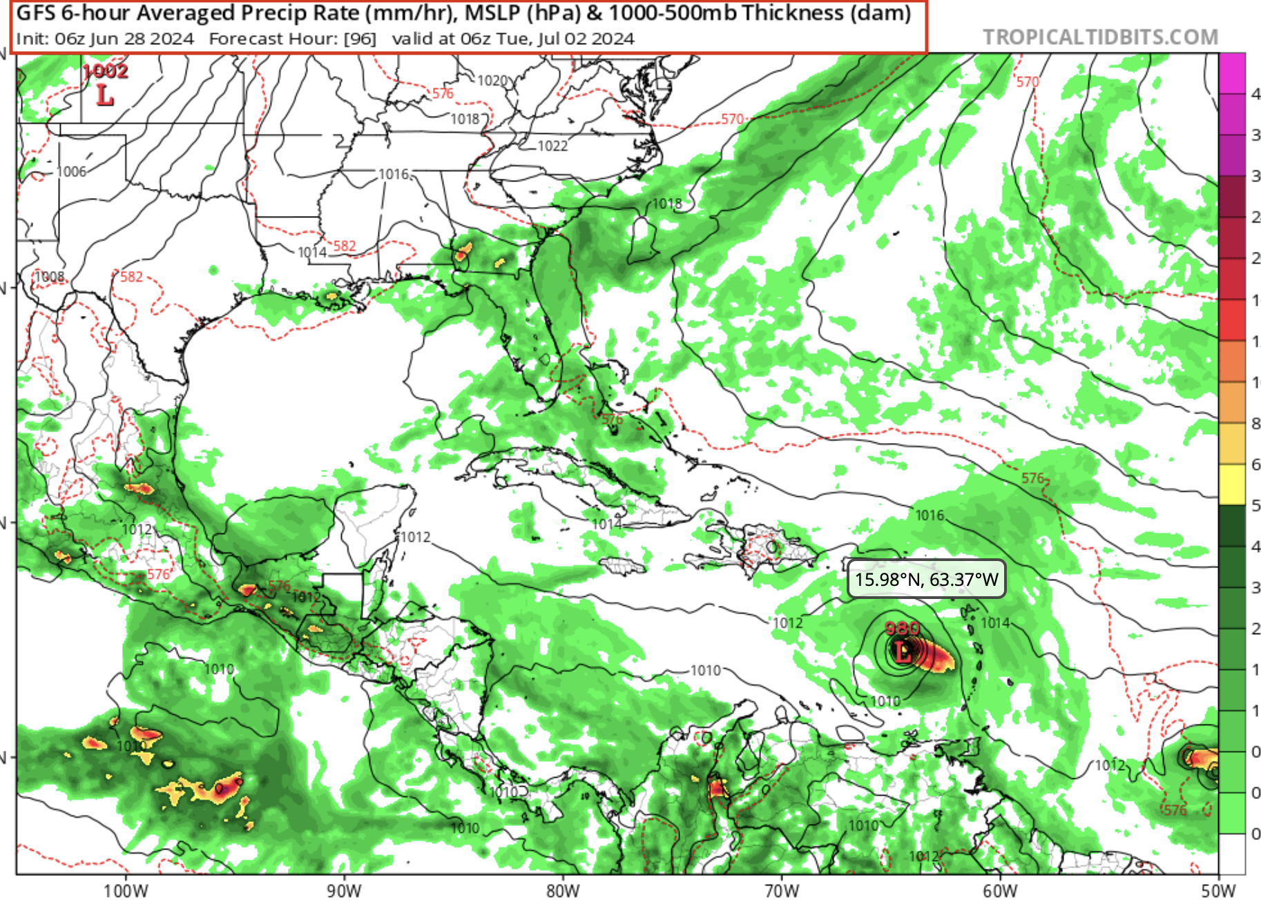
We are posting 96 hours models today or 3 days out.

Both GFS [NOAA] and ECMWF [European] are almost matching.

GFS first...

TS Beryl GFS 96.png


_____________

ECMWF model...

TS Beryl 96hr.png


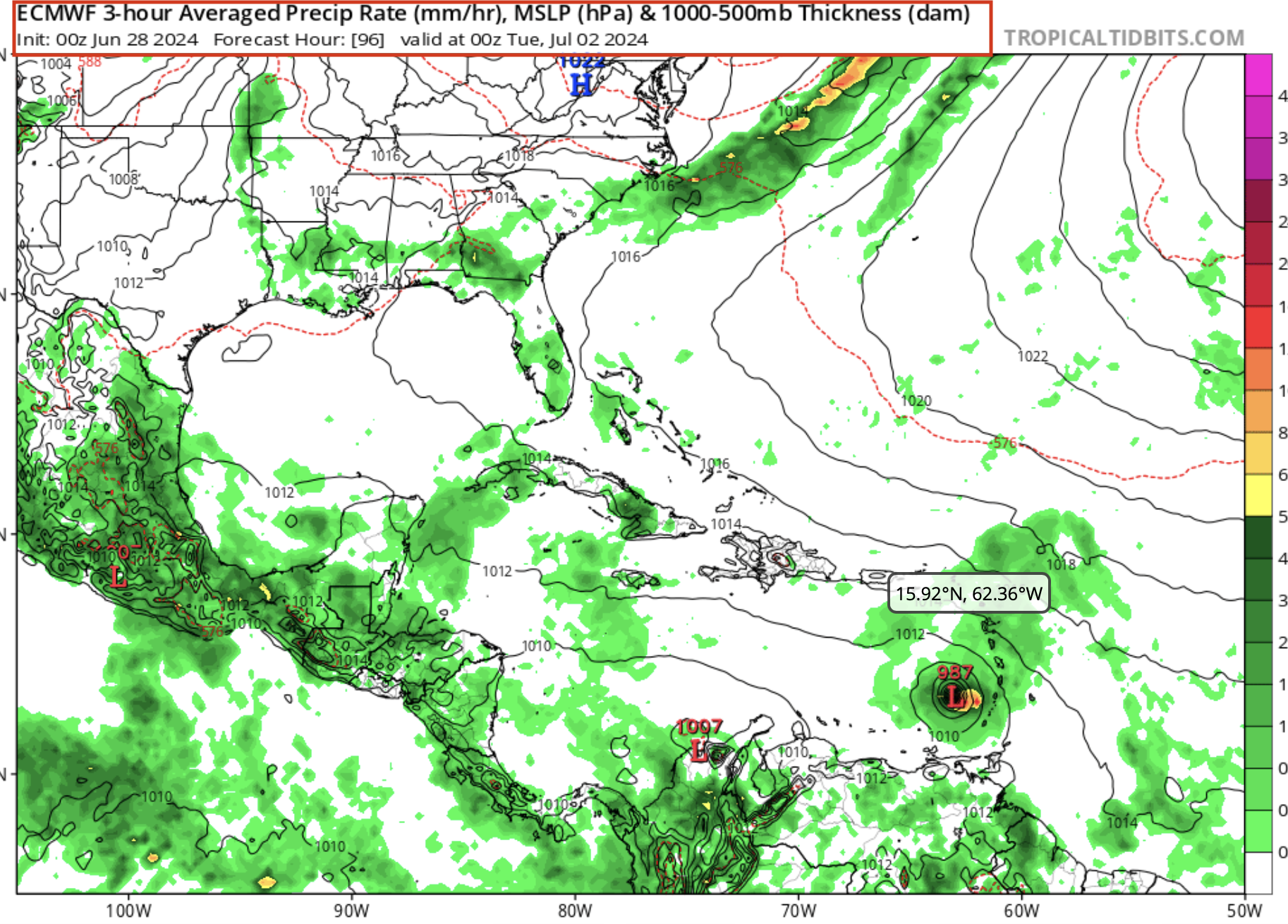
This will be Named BERYL or pronounced "Bear Rill"

More info coming each day on this Storm.

But showing the Hurricane Fuel or HEAT today.

ohc_aQG3_latest_natl.gif


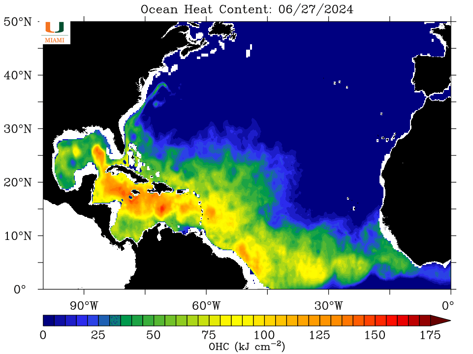
So time to prepare for the Season now.

Jim and John

PS:
Hurricane Preparedness
 

WayneH

.
Jan 22, 2008
1,045
Tartan 37 287 Pensacola, FL
I've been watching this one for a while. It looks like it is going to mess up my family reunion week and cause me to drive the 3/4 ton pickup halfway across the country. UGH! This might be the one time I hope it hits Central Texas. The lakes around here are low. Lake Medina is at 2.3% of conservation level.
 

JamesG161

SBO Weather and Forecasting Forum Jim & John
Feb 14, 2014
7,561
Hunter 430 Waveland, MS
I've been watching this one for a while. It looks like it is going to mess up my family reunion week
My Bet is on the ECMWF Model.

John and I bet different.

3 more days Wayne, but your reunion in Central Texas should be ok. [I hope :biggrin:]

Windy.com will be your best bet for the reunion forecast.

Jim...
 

JamesG161

SBO Weather and Forecasting Forum Jim & John
Feb 14, 2014
7,561
Hunter 430 Waveland, MS
Now just happened ....

Tropical Depression #2

Here we go for a fun filed July 4th week.

Jim...
 

jssailem

SBO Weather and Forecasting Forum Jim & John
Oct 22, 2014
21,404
CAL 35 Cruiser #21 moored EVERETT WA
Wayne, If your reunion is in Texas around 5 July, you should be ok no matter which model you follow. Here is the forecasted storm location for 5 July 2024. It is seven days away, and anything can happen. There is even talk about Invest 95L blowing through the Lesser Antilles and dying in the Caribbean Sea. The rationale for observing this storm and getting prepared to address such events is to prepare now so you're not rushing when supplies might be gone at the last minute.

Screenshot 2024-06-28 at 16.19.19.png


Screenshot 2024-06-28 at 16.17.24.png
 
  • Like
Likes: JamesG161
Jan 1, 2006
7,165
Slickcraft 26 Sailfish
Jim & John, looking at the OHI it looks to me that the North Atlantic doesn't have as much heat as feared. But I don't have a sense of what normal is. The tropical Atlantic looks very warm, as does the Caribbean and that tongue of warm water in the Gulf. But again how abnormal is that?
 

JamesG161

SBO Weather and Forecasting Forum Jim & John
Feb 14, 2014
7,561
Hunter 430 Waveland, MS
The tropical Atlantic looks very warm, as does the Caribbean and that tongue of warm water in the Gulf.
Let me do a Separate Post on HEAT and Surface Temperatures. The tongue of water = Gulf Stream.
Jim...
 

JamesG161

SBO Weather and Forecasting Forum Jim & John
Feb 14, 2014
7,561
Hunter 430 Waveland, MS
Tropical Storm Beryl is forecast to be 2024 first Hurricane.

There is a Second Tropical wave following it. John told me it was like a "Comet's Tail" trailing behind Beryl.

ECMWF model is the best to follow for now.

TS Beryl.png


48 hours forecast

When the Hurricane Hunters fly into the Storm we will know much more data.

Jim...
 

JamesG161

SBO Weather and Forecasting Forum Jim & John
Feb 14, 2014
7,561
Hunter 430 Waveland, MS
Hurricane Beryl

It is small and compact moving West at 23 mph.

The Hurricane Hunters heading to the Storm now.

Island impact still 1.5 days away.

203825.png


Check back for more information soon.

Dammit Jim...
 
  • Like
Likes: jssailem

JamesG161

SBO Weather and Forecasting Forum Jim & John
Feb 14, 2014
7,561
Hunter 430 Waveland, MS
This is the first data from the Recon Flight into Beryl

recon_AF300-0102A-BERYL.png


Small Eye formed in this Compact Storm.
ohc_aQG3_latest_natl.gif


The 96 hour path takes it over the HEAT fuels area.

115045_current_wind_sm.png


Dammit Jim...
 

JamesG161

SBO Weather and Forecasting Forum Jim & John
Feb 14, 2014
7,561
Hunter 430 Waveland, MS
The fact that Beyrl so Compact , many of the Islands will not even see tropical force winds.

Note Last Pictograph, above.

Dammit Jim...
 
  • Like
Likes: jssailem