• Sailing is all about the Weather.

    Big into the exploration of Atlantic Hurricanes since Katrina came uninvited into his world, James (Jim) Gurley (JamesG161) has followed every Tropical Storm birthed in Atlantic, Gulf and Caribbean waters since. Being a boater, he knows that we often need more time to prepare than we get from the TV weather folk. Jim relies on the science of storm development to share early warning info with friends and fellow boaters.

    Early in 2018, Jim and John Shepard, (JSSailem) started to chat about the weather data available. John asked Jim to help forecast Pacific NW storms, and this morphed into discussions on weather forecasting.

    For John, sailing in the PNW is sometimes hit and miss. One day is ugly, then a string of beautiful days but no wind, followed by a series of blue-sky days and 12 knot breezes. Being ready for those great sailing days means you need to look to the Pacific Ocean and what is brewing. John has been into Pacific NW Weather since the 1970’s when his first PNW November storm hit bringing more than 40 days and 40 nights of continual rain.

    Together we want to share information, new APPs, safety, and thoughts about letting the weather help you. Identify some of the resources for sailors and help prepare you for your next sailboat outing.

    It is far better to go out on the water knowing what to expect in weather terms, than to be out on the water and see dark ominous clouds suddenly appear, unprepared.

Invest 94L --> PTC Two --> TS Bonnie-?

Feb 14, 2014
7,445
Hunter 430 Waveland, MS
This tropical LOW Pressure began in Mid Atlantic.

storm_94.gif


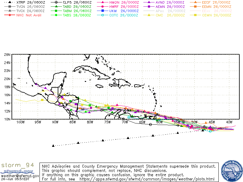
I like this tracking graph for best predictions in next 96 hours. The 3-Green models or TABx were graded best prediction in 2021.

This storm started too far South which will cause it to split the LOW, half on Land. Thus minimum HEAT Fuel.
____
The Westerlies are moving at ≈25 mph, making Invest 94L a fast moving Storm. [Good Thing]

It should be named Bonnie around July 1st, as it enters the HEAT South of Cuba.

ohc_aQG3_latest_natl-2.gif

Jim...

PS: The Sahara Dust and Low HEAT seem to be controlling the Atlantic Season so far.
 
Last edited:
Feb 14, 2014
7,445
Hunter 430 Waveland, MS
NOAA just flew their exploratory mission into...

Potential Tropical Cyclone Two

recon_NOAA2-01BBA-INVEST.png


PTC Two is still weak, but it will strengthen in next 2 days.

AL022022_5day_cone_no_line_and_wind.png


It is moving West very fast at 18 mph. [Typical 10-12 mph]

It will be named Bonnie on Friday.

Time to think about the Hurricane Season...
Jim...
 
Feb 14, 2014
7,445
Hunter 430 Waveland, MS
PTC #2 is happening like our first post. Skimming South America is killing it.

Tip: In order become TS Bonnie it must have a closed circulation, which is not happening, yet.

NOAA on a flight training mission looking again.

recon_NOAA9-WXWXA-TRAIN_dropsondes.png


Jim...
 
  • Like
Likes: jssailem
Feb 14, 2014
7,445
Hunter 430 Waveland, MS
As we predicted [bragging, better that NOAA], it barely became a Tropical Storm late Friday.

TS Bonnie got anTropical Atlantic area Name and a Letter designator "L".

At this time, it is now in the East Pacific and now given Letter designator "E".:doh:

To make this really confusing, for the Statistics, we now have this...

TS Bonnie L
and
TS Bonnie E which will become a Pacific Hurricane soon.

That is the reason I put in the Title of this Posting "?"

Oh well...
Jim...

PS: NHC has responsibility for World Wide monitoring on areas L and E.
 

Johann

.
Jun 3, 2004
424
Leopard 39 Pensacola
Simple
Oh My Gosh! :doh::yikes::eek:o_O:puke::wow3:

Boy NOAA is bored.

They must of measured the 40 mph wind speed on a kids beach Kite

I can not find that wind speed on Windy.com

Jim...
Anything to get through the alphabet it seems. Are they sure it wasn’t 34.9 kts?
 
Oct 22, 2014
21,141
CAL 35 Cruiser #21 moored EVERETT WA
Maybe they have a pool going on how far they get through the storm list. Or a christmas bonus on the number of named storms during the season.
 
  • Like
Likes: Johann