• Sailing is all about the Weather.

    Big into the exploration of Atlantic Hurricanes since Katrina came uninvited into his world, James (Jim) Gurley (JamesG161) has followed every Tropical Storm birthed in Atlantic, Gulf and Caribbean waters since. Being a boater, he knows that we often need more time to prepare than we get from the TV weather folk. Jim relies on the science of storm development to share early warning info with friends and fellow boaters.

    Early in 2018, Jim and John Shepard, (JSSailem) started to chat about the weather data available. John asked Jim to help forecast Pacific NW storms, and this morphed into discussions on weather forecasting.

    For John, sailing in the PNW is sometimes hit and miss. One day is ugly, then a string of beautiful days but no wind, followed by a series of blue-sky days and 12 knot breezes. Being ready for those great sailing days means you need to look to the Pacific Ocean and what is brewing. John has been into Pacific NW Weather since the 1970’s when his first PNW November storm hit bringing more than 40 days and 40 nights of continual rain.

    Together we want to share information, new APPs, safety, and thoughts about letting the weather help you. Identify some of the resources for sailors and help prepare you for your next sailboat outing.

    It is far better to go out on the water knowing what to expect in weather terms, than to be out on the water and see dark ominous clouds suddenly appear, unprepared.
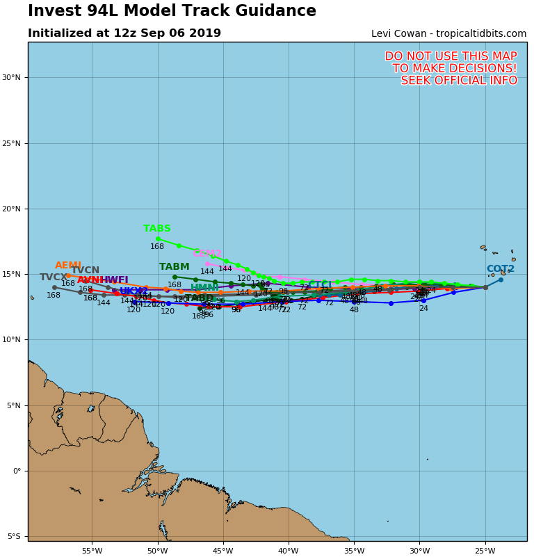
Invest 94L

Feb 14, 2014
7,418
Hunter 430 Waveland, MS
NOAA beginning to track an small disturbance off West Africa. This is a West moving disturbance.
Two of the reliable models are conflicting on what happens by Sept 11.

There is very little wind shear to slow down its formation.
94L_tracks_latest.png

We will see more by Sunday.
Jim...
 
Feb 14, 2014
7,418
Hunter 430 Waveland, MS
After reviewing the models and information...
This blip appears to run into negative wind shear.
So...
Bye bye 94L
Jim...

PS: There is a new wave expected off Africa by Wed 11.
ALL clear for next 10 days:biggrin:
 
  • Like
Likes: jssailem
Oct 2, 2008
3,807
Pearson/ 530 Strafford, NH
Could you remind me of why those wind disturbances are numbered in the 90’s.
 
Oct 1, 2007
1,858
Boston Whaler Super Sport Pt. Judith
My guess would be a limit on some app. 100 too many characters. 80 would make it look too old. 90 is the sweet spot.
 
  • Like
Likes: jssailem
Feb 14, 2014
7,418
Hunter 430 Waveland, MS
Could you remind me of why those wind disturbances are numbered in the 90’s.
The Northern Hemisphere is spilt up [4 parts] for the tropical season and computer model tracking numbering.
They start at 90, my guess is the top 90° Latitude.

Rare, but it happens, to have a NON-Tropical disturbance.

The very Active Pacific has used 94 already, but 94W.

INVESTigation 94L will go away.:snooze:

Next up, 95L... probably by Wednesday. [Double secret info for 95L :snooty:]
______
Believe It Or Not [BION]...
Equatorial Pacific and Atlantic are cooler than normal:pimp:
That helps keep any disturbance lower in intensity.

Tip: 10 day forecasting is a long stretch. NOAA sometimes says 5-7 days.

Jim...

PS: El Niño lasted for ≈6 months. The Pacific is cooling so fast it is almost La Niña conditions.o_O
 
Feb 14, 2014
7,418
Hunter 430 Waveland, MS
Here is National Hurricane Center glossary of terms.
Glossary of NHC Terms

My Favorite is...

Tropical Wave

I was shocked by that one.
Thought it was that tan beauty, waving at me, while I sipped my third "Bahama Mama" beverage at the beach.:laugh:
 
Oct 22, 2014
21,088
CAL 35 Cruiser #21 moored EVERETT WA
Yes we have Sasquatch alive and well out here. I was in Kingston WA last Friday and I came across...

IMG_5364-1.JPG


IMG_5969.jpg