Tropical Season 2017 Atlantic and Gulf of Mexico

Feb 14, 2014
7,418
Hunter 430 Waveland, MS
Any activity for this season should be generally low in intensity.
Our Sun is cooling on it natural Energy cycle.
Cycle22Cycle23Cycle24big.gif

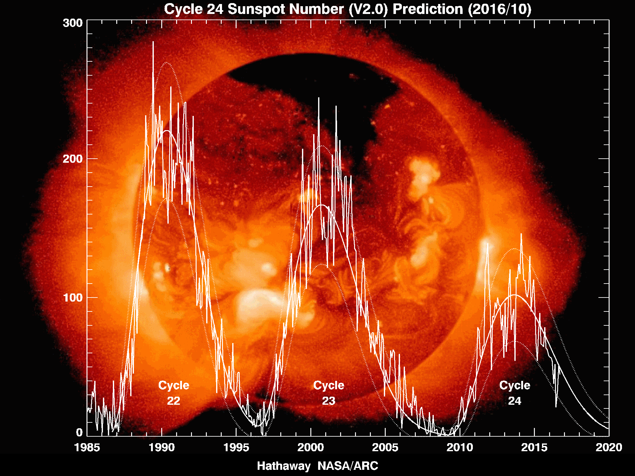
Many real scientists are predicting the ≈11 year cycle to continue through cycle #26 or ≈22 yrs
The above graph is from...
https://solarscience.msfc.nasa.gov/predict.shtml [NASA]

Many scientists are stating this is the coolest our SUN had been in over 100 years.

Since Tropical Intensity is powered only by the Sun [ Solar energy can be stored by our oceans] we all should still prepare.
_________
Trivia: A now famous person predicted in 1998 a disaster. Remember the "hocky stick" curve he declared (above graph starting in 1995) would continue forever?

Oh well, so much for Trivial things.;)
_________
Many factors are now being Modeled to help us forecast Tropical waves. Models are being improved with much more information, now available to scientist.

This is just my humble opinion of 2017 outlook and tropical weather only.

Wishing all a Safe 2017!
Jim...
 

Gunni

.
Mar 16, 2010
5,937
Beneteau 411 Oceanis Annapolis
NASA CO2 graph.jpg
Since Tropical Intensity is powered only by the Sun [ Solar energy can be stored by our oceans] we all should still prepare.
Well, only if you ignore the changes in our atmosphere's gas mix and related ability to hold solar heat...and the affect that has on the jetstream.

Trivia: A now famous person predicted in 1998 a disaster. Remember the "hocky stick" curve he declared (above graph starting in 1995) would continue forever?
Yep, the CO2 hockey stick...looks pretty much right on track to 500 ppm!


Hmm, the sun is cooling but the earth is getting hotter? Must be a lot more complex that whatever is going on with the Sun!
GlobalTemps-NASA.png
 
Last edited:
Nov 6, 2006
9,892
Hunter 34 Mandeville Louisiana
We are hoping for a quiet season down here.. Thanks for the note, Jim.. We had right at +5 feet of water on the North Shore of Pontchartrain for the little tropical storm a few weeks ago.. but no serious wind.. Keeping fingers crossed
 
Feb 14, 2014
7,418
Hunter 430 Waveland, MS
I didn't mean global warming issues, but CO2 may hold the Suns heat in, seasonally.

Only the Sun provides significant energy to oceans, and the hockey stick was Temperature climb in the Arctic [ not Antarctic] in 1998. The CO2 model was a best guess back then.
_______
So the key to storm intensity is ACE.
https://en.wikipedia.org/wiki/Accumulated_cyclone_energy


Which is essentially Solar energy stored in our oceans to power storms. Thus NOAA uses ACE to predict 2017 storm potential.

Trivia: How long would the world oceans stay liquid at the surface, if our SUN went out?
________

Jim...


Scientific answer to trivia...
< 24 hours.

3 days to freeze to deepest spot.:yikes:
 
Feb 14, 2014
7,418
Hunter 430 Waveland, MS
El Nino has diminished out in the Pacific
:plus:
Actually we barely had La Niña which intensifies ACE. Now we are inter-Pacific effects.

I use this forum to forecast ahead of the wimps to help when I can help prepare the local people too.

So you will never get :poke: or :kick: from me, but I do the science.
I did this here in 2016 too.
Jim...
 
  • Like
Likes: kloudie1
Nov 6, 2006
9,892
Hunter 34 Mandeville Louisiana
Jim... 3 days?? You obviously are not taking into account the heating that would occur when millions of people had the crap scared out of them (by the dark) and all flushed at the same time !
 
  • Like
Likes: JamesG161
May 24, 2004
7,131
CC 30 South Florida
I don't know about the Sun cooling down but here in FL it has been hotter than previous years and the Eastern Gulf water temperature is 90 F. Based on years of previous experience when the Gulf water temperatures are this warm I would not count out, nor dismiss the possible formation of strong systems.
 
Oct 1, 2007
1,858
Boston Whaler Super Sport Pt. Judith
One thing we can seemingly depend on is that whatever the "experts" predict, it is very unlikely that they will be correct in their forecasts. Ergo, prediction for more storms, history shows likely less, and vice versa. Mind you their predictions lean to the aggressive side. On top of that their ability to actually forecast storm formation and development seems to be struggling. Witness recent 94L and the follow on tropical wave. It could be they are trying too hard.
 
  • Like
Likes: JamesG161

Gunni

.
Mar 16, 2010
5,937
Beneteau 411 Oceanis Annapolis
the Eastern Gulf water temperature is 90 F.
Yes, and although that is not altogether odd, what is different is that decreasing upper atmospheric shear from a dying El Nino will leave us vulnerable in the Atlantic to storms that are free to build and grow in the warm waters of the gulf and the tropical Atlantic. A formerly strong El Nino effect protected us on the east coast in the last few years, no more.
 
Feb 14, 2014
7,418
Hunter 430 Waveland, MS
I don't know about the Sun cooling down but here in FL it has been hotter than previous years and the Eastern Gulf water temperature is 90 F. Based on years of previous experience when the Gulf water temperatures are this warm I would not count out, nor dismiss the possible formation of strong systems.
:plus::plus::plus:
For dang sure.

One tool I find useful to watch ACE, as you suggest... local water temps too.
Here is the Temperature Anomoly as of today a 7pm CST....
Temps.jpg

Water temperature anomalies mean, Change from the long term averages at this Date and H or L which are pressure fronts.
White or pale = average
Reds shades show darker as the water temp is higher than normal.
Blue shades show cooler or lower than average.
Also note the thin blue trace along the coasts, this is cooler rain water entering the ocean and surf cooling. This is Wundermap from...
https://www.wunderground.com/
Wundermap lets users adjust, display various data, and ZOOM in.
____
Ok here is My take on current Water temperatures in hurricane kindergarten areas which I have shown.
Slightly warmer than normal.:)
The water is much hotter (than normal) south of Mobile Al than currently around Florida. Tampa area a bit warmer (than normal) too.
______
Hopefully all the effects that would increase ACE, continue to be ≈NORMAL This is MID July and thus solar intensity is falling, but stored solar energy in the oceans is increasing.:confused:

Rain is natures way of removing stored ocean energy. Not much ocean rain storms yet.

We want more rain but not with high winds.:clap:
Jim...

PS: As noted by many comments above, there are many factors, but the SUN is the driving force.
 
Jun 21, 2004
2,533
Beneteau 343 Slidell, LA
I mostly ignore all of the experts' opinions. All it takes is one hurricane strike in your locale and it's an absolutely disaterous storm season, not to mention the years that it takes to put your life in order again.
 

Gunni

.
Mar 16, 2010
5,937
Beneteau 411 Oceanis Annapolis
People in Slidell don't need a weatherman to tell them they are in the sights of devastating tropical storms and the one protection they have, the marshes, are being sliced and diced by man.
 
Last edited:
  • Like
Likes: My Mistress
Feb 14, 2014
7,418
Hunter 430 Waveland, MS
People in Slidell
:plus:
And note my hailing port of Waveland, MS.

The main eye of Katrina passed directly between Slidell LA and Waveland MS. ≈12 yrs ago and, we are no where near recovered.

Editorial Note: The terrifying emotional scars left on my friends, is the main reason I began my personal scientific studies of Hurricanes. They have found I give them better, earlier, and calming forecasts than the News. I decided to share the same info here. Located 12 miles from both Slidell and Waveland is NASA Space Center and now houses the US Navy's Globals weather center. That is where all Naval missions get their unified, top secret, weather data etc. I have friends that link non-classified , trusted, weather data sites.;)
In addition, my son-in-law is top electrician that manages LA oil rig maintenance. He has linked me to their weather services that forecast open Gulf Waters too.
If we get such a large storm potential again, I plan to move my boat up the Pearl River, near NASA Saturn V fuel locks, tie off to a tree bigger than 14" diameter, dual anchor ground tackle, put a old iPad aboard (gps follow me) and leave her to do as designed, take 10 meter waves like a cork.:pray: @BigEasy and @kloudie1 are welcome to join me.
_______
I am not out on a limb forecasting lower Intensity than NOAA for the season.:)

Jim...

PS: Check out "Mission to Mars" on the NASA link. When they tested the main engine, my house vibrated.:yikes:
 
  • Like
Likes: BigEasy
Jun 21, 2004
2,533
Beneteau 343 Slidell, LA
Jim,
Thanks for posting the weather data; always interesting looking at the statistics. Any guess why as to why CO2 levels spiked approximately 67% 100,000, 250K, and 350K years ago? Not many cars, factories, population, etc. contributing to CO2 levels then. I do believe that sensible efforts to safeguard the environment is a prudent thing; however, it is obvious that there are factors that are well beyond our control that have far greater effects on climate than man made causes.
Weather is always a big consideration when sailing, especially offshore. I do believe, as sailors, that we should be more knowledgeable than the average person. I took an online course, that is sponsored by the US Power Squadron , a couple of years ago. Well worth the cost and efforts. The course is available from the Universtiy of West Florida thru their online portal. After registering for the course the USPS headquarters will mail the 250 page course/workbook. The course covers atmospheric considerations, wind-pressure-waves, humidity-fog, clouds -precipitation, thunderstorms-tornadoes-lightening, mid latitude weather, tropical weather-storms, and forecasting. It is aworthwhile effort and adds a new dimension to your knowledge when watching weather forecasts & looking at local conditions when you're on the water.
Finally, thanks for the heads up on your hurricane hole! If necessary, I plan to move the boat over to a new marina in Slidell that has floating docks & strip off the sails & bimini. Double lines & fenders. I faired very well with the previous boat with the same plan; however, didn't do so well with Katrina. Another option is to move it to Seabrook Marina and haul out for a major storm---the yard is enclosed within the New Orleans 20+ feet flood system. The time constraints are always the biggest factor for storm preparations. Usually by the time there is an accurate storm forecast, you have two days---one day to secure everything (boat & house), find a place to evacuate to, pack up your valued possessions, and get the hell out of Dodge. The boat only gets a half day for storm prep. Been through this too many times; I hope your storm forecast holds up!!
 
Feb 14, 2014
7,418
Hunter 430 Waveland, MS
Any guess why as to why CO2 levels spiked approximately 67% 100,000, 250K, and 350K years ago? Not many cars, factories, population, etc. contributing to CO2 levels then.
BTW most of that data was taken from Arctic Ice coring data that entrapped various gases. Not many cows back then either.;) Volcanic activity is best guess by most geologist, since they also track limestone deposits that match. High CO2 consumers like, coral, oysters, etc that eventually make Limestone (Ca/Mg Carbonates from CO2) are traced during drilling coring too.
BTW our Oceans consume most of the CO2 and in turn makes most of the O2 (95+%) using our Sun energy to help do the transformation. I will not offer more info on the now Political discussion in the news and will just discuss Hurricane info. I will stick to science.
_________
Slidell that has floating docks
One caution... look at the dock's guide bollard's elevations.. once water floats the dock higher than the bollard top, they become spears to puncture your hull. (another post showed that in a Matthew damaged boat, I didn't chime in to that one, but it was on a floating dock)

Storm surge should be minimal 30 miles or more up the Pearl River. Most boats there survived Katrina. Most boats on the hard didn't.

If we all go up the Pearl, we can hoist a few Pearl beers too.
Jim...
 
  • Like
Likes: kloudie1
Nov 6, 2006
9,892
Hunter 34 Mandeville Louisiana
Appreciate the thought, Jim.
We did pretty well for Katrina on the North Shore.. Our quaint, old marina is off the lake front by about a quarter mile and is surrounded by trees .. the trees break the wind at the surface a lot so we have to deal with the hurricane surge more than the wind; still significant wind, but not like close to the lakefront.. .. I have been in that marina since 1978 and Katrina was the worst.. I lost the top port side lifeline when it fouled the top of the 9 foot (above normal water level) tall piling, as the water was falling. I'd not had any damage from any previous storm. Lucky.
 
Feb 14, 2014
7,418
Hunter 430 Waveland, MS
same weight as the weatherman's.
That is why I posted it in this forum.

No need to listen ever to my non-wimp forecast when the storms are near. You pay for NOAA, I am just an amateur batting 950.:waycool:
_______
Science Trivia: Temperature is just an attempt to measure the Heat/Energy content of something. By itself it tells you nothing about the Built up or stored Energy, in say water. Thus the advent of weathermen saying

"Feels like..".

The real forecast hurricane models use ACE. See post #4 above.
_________
Have a safe Hurricane season and prepare now!:)
________
That is the key.

Jim...
 

Gunni

.
Mar 16, 2010
5,937
Beneteau 411 Oceanis Annapolis
Any guess why as to why CO2 levels spiked approximately 67% 100,000, 250K, and 350K years ago? Not many cars, factories, population, etc. contributing to CO2 levels then.
Those spikes follow the pattern of our planetary ice ages, warming oceans release CO2. What you see is the natural CO2 release spike of ocean CO2. Then you see the industrial age and the unprecedented CO2 effect of mankind burning off stored carbon (coal, petroleum)...setting off even more warming ocean CO2. Atmospheric CO2 reached 409ppm in June.