Swinomish updates?
- Thread starter forbin
- Start date
Brian,
Have not been through the "ditch" since last year. I am planning to head through the first part of August. Let me know if you hear anything. The 2 skippers I know up there are both up in the Islands. One keeps his H42 up in Shelter Bay. I would have heard something if there was a serious issue. Suggest you consider his guidance... "never run the ditch on a minus tide".
For safe passage I look for a plus 1ft tide at La Conner.
Here are my log notes from last year at this time.
Navigation
Estimate the time of slack water and duration of current flow in the Swinomish Channel at La Conner.
The tugboat operators base their estimate on the tide tables. Slack water at La Conner Landing occurs between 2 and 3.5 hours after high or low water. For example, if High Water at La Conner occurs at 5 a.m., slack will be sometime between 7 a.m. and 8:30 a.m. at periods of a minor tide change, the slack will occur closer to 2 hours after the predicted high or low. When there is a large change in tide, the current turns almost 3.5 hours later. The current flows north for 2 to 3.5 hours before high water until 2 to 3.5 hours after high water; it flows south for 2 to 3.5 hours before low water until 2 to 3.5 hours after low water.
The 1.5-hour leeway leaves a lot of room for guessing, and some local boaters prefer to use a different method as their guide. Slack water occurs when the high water drops 2 feet. Similarly, low water slack occurs after the low water has risen 2 feet. When the tide change is less than 2 feet, one can expect an accordingly small amount of current.
When running during low tides in the southern part of the Swinomish Channel, boaters should favor the east side of the channel from the southernmost house in the Shelter Bay Community to the entrance of Shelter Bay itself. There is a rock wall breakwater on the east side, which should be favored. The western 2/3 side of the channel is very shallow from sediments deposited by the nearby Skagit River.
Have a safe passage.Estimate the time of slack water and duration of current flow in the Swinomish Channel at La Conner.
The tugboat operators base their estimate on the tide tables. Slack water at La Conner Landing occurs between 2 and 3.5 hours after high or low water. For example, if High Water at La Conner occurs at 5 a.m., slack will be sometime between 7 a.m. and 8:30 a.m. at periods of a minor tide change, the slack will occur closer to 2 hours after the predicted high or low. When there is a large change in tide, the current turns almost 3.5 hours later. The current flows north for 2 to 3.5 hours before high water until 2 to 3.5 hours after high water; it flows south for 2 to 3.5 hours before low water until 2 to 3.5 hours after low water.
The 1.5-hour leeway leaves a lot of room for guessing, and some local boaters prefer to use a different method as their guide. Slack water occurs when the high water drops 2 feet. Similarly, low water slack occurs after the low water has risen 2 feet. When the tide change is less than 2 feet, one can expect an accordingly small amount of current.
When running during low tides in the southern part of the Swinomish Channel, boaters should favor the east side of the channel from the southernmost house in the Shelter Bay Community to the entrance of Shelter Bay itself. There is a rock wall breakwater on the east side, which should be favored. The western 2/3 side of the channel is very shallow from sediments deposited by the nearby Skagit River.
Thanks for the notes. There's no way I'd attempt to go through at a minus tide! We're thinking about 5 PM on Saturday (pending all other variables) which would get us through at high tide (+10-ish) but not sure where to go on the other side. I don't really want to stay in Anacortes. My preference is still crossing the strait and secondly Deception Pass, but we'll wait to see how the weather looks.Suggest you consider his guidance... "never run the ditch on a minus tide".
Looking up your boat on saildata.com I see it draws about 5.5 MAX Draft. My tide chart at La Conner indicates a +2ft rising on or after 14:00 22 July. I would think you are good to go anytime after 14:00. You will ride an incoming tide which will be flowing through the ditch. At least till you get beyond La Conner. Then it will be against you. As I remember the rate is about 2-3 knots at max flow. The slack is 2-3.5 hours after high tide at La Conner. According to my chart High Tide is 18:21. Be safe and stick to the center channel unless you see a TUG hauling through the ditch. Then I figure it is everyman for himself... (They usually prefer traveling the ditch at high tide and at night from what I have heard. Good reason to get an inside spot in La Conner.)
I like to stay in La Conner. Fair rate for overnight and I have always found them very friendly. The last time I stopped they had my name on the dock and a young lad to tend lines as I came in. Besides the brew pub is a short walk from the marina.
(They usually prefer traveling the ditch at high tide and at night from what I have heard. Good reason to get an inside spot in La Conner.)I like to stay in La Conner. Fair rate for overnight and I have always found them very friendly. The last time I stopped they had my name on the dock and a young lad to tend lines as I came in. Besides the brew pub is a short walk from the marina.
This one is one of the earlier models when the deep draft was available...so we're 6.5'. Last time I went through, at least at the south end, the depth several feet lower than I expected while I was right in line with the range markers so I like to give myself a lot of margin, especially with other boats around (luckily no tugs so far...)Looking up your boat on saildata.com I see it draws about 5.5 MAX Draft. My tide chart at La Conner indicates a +2ft rising on or after 14:00 22 July. I would think you are good to go anytime after 14:00. You will ride an incoming tide which will be flowing through the ditch. At least till you get beyond La Conner. Then it will be against you. As I remember the rate is about 2-3 knots at max flow. The slack is 2-3.5 hours after high tide at La Conner. According to my chart High Tide is 18:21. Be safe and stick to the center channel unless you see a TUG hauling through the ditch. Then I figure it is everyman for himself...
I like to stay in La Conner. Fair rate for overnight and I have always found them very friendly. The last time I stopped they had my name on the dock and a young lad to tend lines as I came in. Besides the brew pub is a short walk from the marina.
I was going by this...
"Current flows north from 2.5 to 4 hours before high tide to 2.5 to 4 hours after."
...so I was thinking the current would be flowing with us the whole way (assuming we entered at 5 and given high tide at 18:21)...no?
I did have a good pizza at the brewery there...as well as some of the brew.
Based on my limited observations.. I see the tidal flow is stronger and earlier in the day through Deception Pass than Guemes Channel. So the tide rises earlier at La Conner (flowing north earlier in the day) than at the north Swinomsh Channel entrance Padilla Bay, Washington (the train swing bridge). So yes you'll have the current with you from 14:00 on. By 17:00 there should be 9 plus feet of incoming tide in La Conner. Plenty deep for your 6.5' boat.
Here is Terry's post from last year... It might add to your planning knowledge.
https://forums.sailboatowners.com/i...siting-the-ditch-er-swinomish-channel.176907/
Here is Terry's post from last year... It might add to your planning knowledge.
https://forums.sailboatowners.com/i...siting-the-ditch-er-swinomish-channel.176907/
RR bridge construction. Beware Swinomish closures 6 hr. dailey from now to end of August. Will try to find internet construction closure schedule
Charles
Charles
Hey - one more question...how is the depth at the Deception Pass State Park floats? I can't seem to find much about it. This is another option we're looking at. Seattle - Langley - Deception Pass (4 PM slack) but if we got delayed or the wind kicked up too much we'd need a good spot to stay up by Deception Pass to try for a morning transit...thoughts?
My chart (NOAA 18427) has the float depth at 4.1 Fathoms. Friends have also used Hope island as a spot to wait the tide out. There are park buoys on the north side of the Island in 2-4 fathoms. The south side has pretty skinny water
Tidal Current chart on 22 July (measured at the bridge) goes above 4.0 knots against your passage (water moving west to east) at 10:00 and doesn't slow below 4 knots until 15:06. 4 knots is about the max I like to play with in that narrow passage. Slack occurs about 16:00 and after that you will get assistance. Bowman Bay (state park) is pretty cool on the west side of the passage. Depths are good (2 fathoms) on the west half of the bay. They have mooring buoys. As long as the swell is not out of the south west you should have a comfortable evening.
Tidal Current chart on 22 July (measured at the bridge) goes above 4.0 knots against your passage (water moving west to east) at 10:00 and doesn't slow below 4 knots until 15:06. 4 knots is about the max I like to play with in that narrow passage. Slack occurs about 16:00 and after that you will get assistance. Bowman Bay (state park) is pretty cool on the west side of the passage. Depths are good (2 fathoms) on the west half of the bay. They have mooring buoys. As long as the swell is not out of the south west you should have a comfortable evening.
Brian - If it were me, coming from Eliot Bay, I'd take the route via Port Townsend. In 30 years I've only gone the Swinomish Channel twice, once going north and the second time going south, and didn't like it either time. One is "supposed" to go slow and not kick up a big wake; however, that's typically not for the other guys. This is a very popular powerboat route and being a channel they pass close abeam and you get stuck with their wake with no way to maneuver out of it. Not a very nice scenario. The winds and currents going the Port Townsend route aren't necessarily all that bad depending on how one works it.
I'd get an early start on Saturday catching the ebb, slack at Pt. Wilson is a bit before 11:30 am, then get out in the main channel to catch the flood going north. The morning winds are forecasted to be out of the south then the afternoon winds past Point Wilson will be out of the Strait and be blowing up toward Anacortes along with the flood from the -2.9 tide (-3.1 on Sun).
If one leaves Elliot Bay kinda late as was indicated being a possibility, it's not all bad. Head over to the Kitsap side and hug the shore to get the back eddies, power around Point No Point, then hit the Skunk Bay back eddy. If you get past Foul Weather Bluff and it's a minus tide, then either (1) beat it over to the cut between Indian Island and the Olympic Peninsula and go under the bridge. With the flood at Pt. Wilson the current here will flow north (depending on the timing). With the bridge one has to check for clearance and there isn't a whole lot of boat traffic there. With the flood at Pt Wilson this is the back eddy route. Or (2), if one misses the minus tide and can't get under the bridge then hug the Marrowstone Island shore and catch the back eddies but check the chart for rocks - there's a couple of 'em. Speed over ground with the help of the back eddies is better than at slack. I actually prefer the back eddy route vs the bridge. There is a lot of current at the Marrowstone Light.
With the long daylight hours if one isn't too late there is time to power past Pt Wilson against the flood (3.3 kt at 2:40 PM on Sat or 3.4 kt at 3:30 on Sun) and get out into the Strait a bit to catch the flood to the San Juans. The wind in the Strait starts to kick up after around 2 PM but not too bad, probably around the 14 to 16 kt range and of course part of it veers down the main channel past Marrowstone Island. The Sunday morning SailFlow forecast shows a strong northerly in the San Juans but decreasing later in the day.
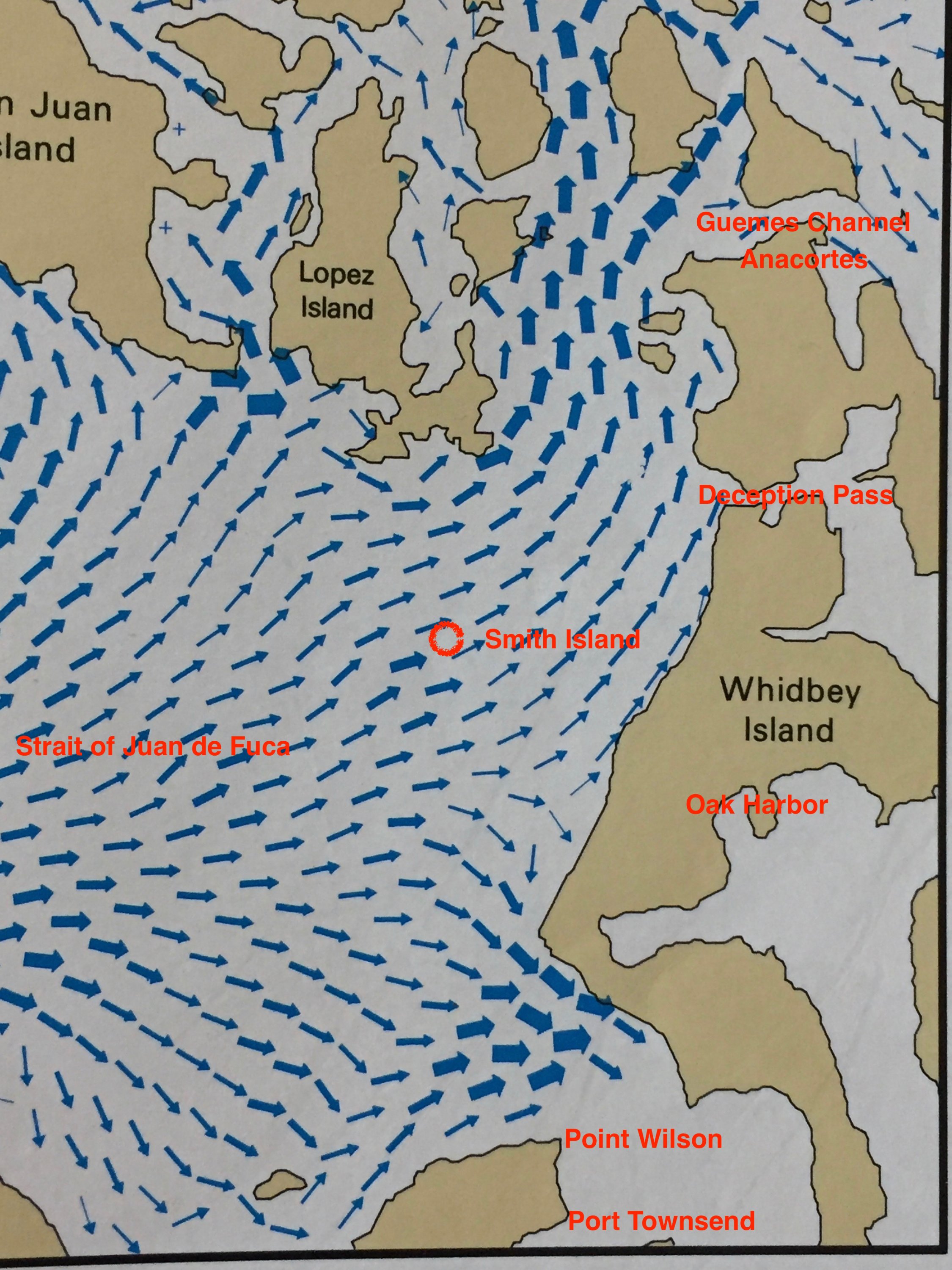
Couple other notes: Wouldn't want to fight against the current through Deception Pass with these minus tides and the area around Smith Island can get pretty lumpy from the various currents. Port Townsend anchorage: avoid the eel grass protection areas.
I'd get an early start on Saturday catching the ebb, slack at Pt. Wilson is a bit before 11:30 am, then get out in the main channel to catch the flood going north. The morning winds are forecasted to be out of the south then the afternoon winds past Point Wilson will be out of the Strait and be blowing up toward Anacortes along with the flood from the -2.9 tide (-3.1 on Sun).
If one leaves Elliot Bay kinda late as was indicated being a possibility, it's not all bad. Head over to the Kitsap side and hug the shore to get the back eddies, power around Point No Point, then hit the Skunk Bay back eddy. If you get past Foul Weather Bluff and it's a minus tide, then either (1) beat it over to the cut between Indian Island and the Olympic Peninsula and go under the bridge. With the flood at Pt. Wilson the current here will flow north (depending on the timing). With the bridge one has to check for clearance and there isn't a whole lot of boat traffic there. With the flood at Pt Wilson this is the back eddy route. Or (2), if one misses the minus tide and can't get under the bridge then hug the Marrowstone Island shore and catch the back eddies but check the chart for rocks - there's a couple of 'em. Speed over ground with the help of the back eddies is better than at slack. I actually prefer the back eddy route vs the bridge. There is a lot of current at the Marrowstone Light.
With the long daylight hours if one isn't too late there is time to power past Pt Wilson against the flood (3.3 kt at 2:40 PM on Sat or 3.4 kt at 3:30 on Sun) and get out into the Strait a bit to catch the flood to the San Juans. The wind in the Strait starts to kick up after around 2 PM but not too bad, probably around the 14 to 16 kt range and of course part of it veers down the main channel past Marrowstone Island. The Sunday morning SailFlow forecast shows a strong northerly in the San Juans but decreasing later in the day.
Couple other notes: Wouldn't want to fight against the current through Deception Pass with these minus tides and the area around Smith Island can get pretty lumpy from the various currents. Port Townsend anchorage: avoid the eel grass protection areas.
Last edited:
Back when I left from SEA, my mantra was be at Smith Is at slack. You might have to leave on the tail end of the flood to do it, but the farther north you get the less impact there is of the opposing current before it changes. This works if the slack after flood is early morning and assuming the tide times cooperate or you could be running during some night hrs. (Assuming you want to work the currents). Stay out of the VTS lanes. Those big guys are sneaky! My first preference is to cross the strait instead of dealing with the channel even if it costs a day due to WX. I've also seen some nice sized "crosswise" logs moving in that channel. Pt. Townsend is a nice layover also..
jssailem: Thanks for the compliment.
Mark -
Normally, around this time of the year we're starting to get into fog, maybe another week or so?
For anyone who is contemplating boating in this area the "bible" for currents" is "Current Atlas, Juan de Fuca Strait to Strait of Georgia" coupled with the annual "Waggoner Tables" counterpart.
Attached is a picture of what the currents look like shortly after things start flooding this weekend. Don't leave home, er .... dock, with out 'em.
It doesn't show all the little counter currents but using one's knowledge of how they are caused one can deduce where to find them. If not, then local knowledge helps. Integrate the current info with wind forecasts and it can help make for better passage making.
Mark -
What can I say .... Amen! It's easy to not want to leave Port Townsend.My first preference is to cross the strait instead of dealing with the channel even if it costs a day due to WX. ...... Pt. Townsend is a nice layover also..
Normally, around this time of the year we're starting to get into fog, maybe another week or so?
For anyone who is contemplating boating in this area the "bible" for currents" is "Current Atlas, Juan de Fuca Strait to Strait of Georgia" coupled with the annual "Waggoner Tables" counterpart.
Attached is a picture of what the currents look like shortly after things start flooding this weekend. Don't leave home, er .... dock, with out 'em.
It doesn't show all the little counter currents but using one's knowledge of how they are caused one can deduce where to find them. If not, then local knowledge helps. Integrate the current info with wind forecasts and it can help make for better passage making.
Last edited: