Have electronic charts changed the way you sail?

TomY

Alden Forum Moderator
Jun 22, 2004
2,759
Alden 38' Challenger yawl Rockport Harbor
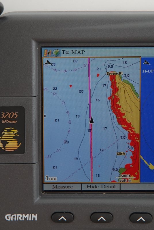
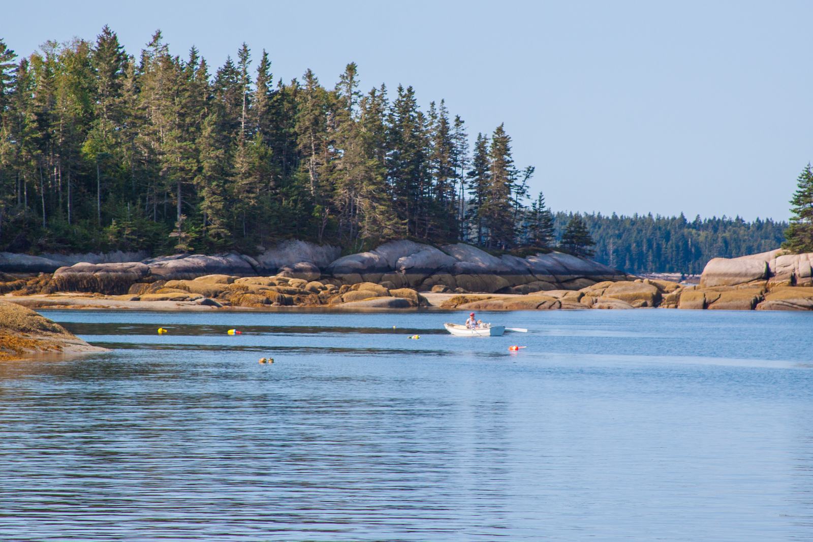
We are coastal sailors and I rely on electronic charts to get us around the rocky coast of Maine. Chart plotters free us up to do things like sail into our anchorage and onto our anchor, which we did here, the night before.

Hells Half Acre circumnavigation #2 (1 of 1).jpg

In the typical Maine morning zephyr, we raised sails and hoisted the anchor to sail out, just for fun again. But the light wind meant we couldn't sail the well marked, Deer Island Thoroughfare on our way east. We'd have to adjust the sails onto a close reach, and tack through places we've never gone before.

Ipad failure .jpg

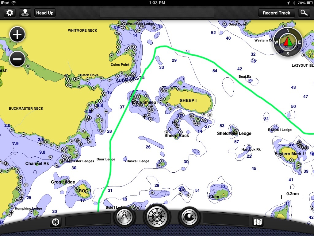
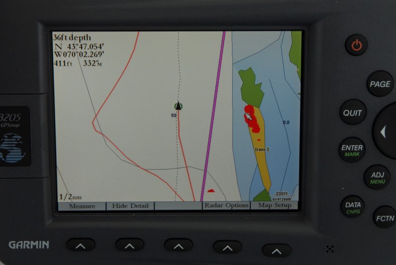
You'll notice on this Ipad with Garmin Blue Chart, the track shows us going right over some rocks. An easy explanation: Our Ipad has an external GPS antenna (bad idea, I think), and the battery went dead. At first you think you're where you boat icon is, and just keep going.

When I noticed the difference on a mounted GPS CP, I figured it out (this has happened before). I also double checked my Iphone to confirm where I was which gave me time to go below and plug the Garmin Glo antenna into the charger(that's were the Ipad track shot straight through the rocks), check depth sounder to E charts, took visual bearings on obvious islands. No panic.


Outside the Deer Isle Thoroughfare (1 of 1).jpg


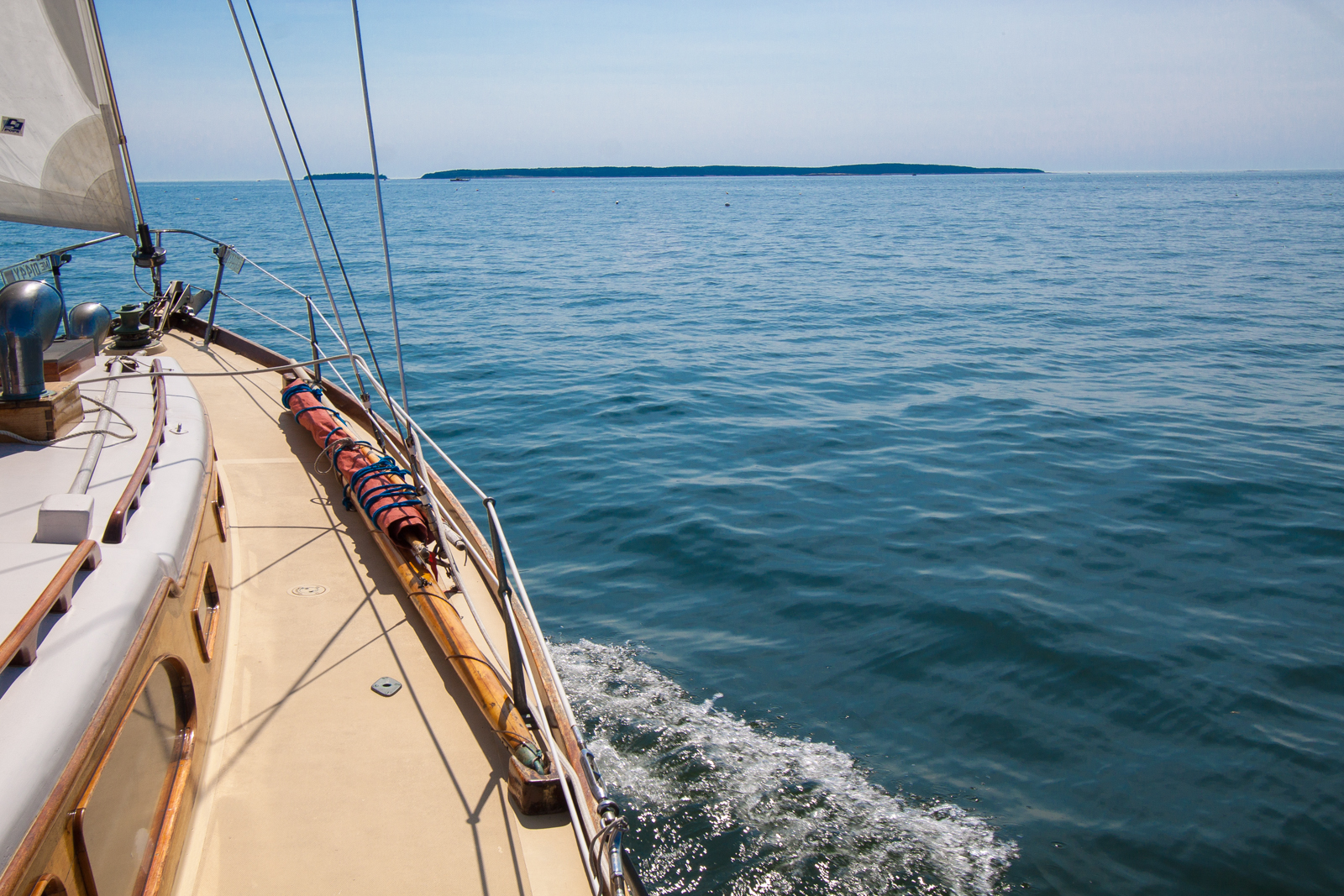
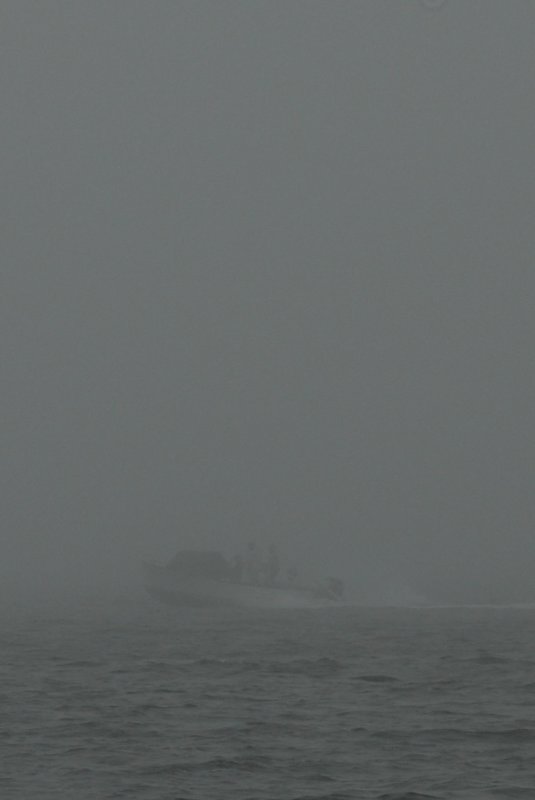
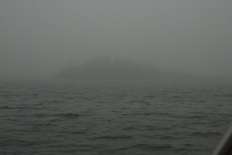
That meandering slow sail, which covered 10.4 miles of water that we've never sailed; outside of the marked channels and through hundreds of unmarked (but well charted) rocks around the edges of Jericho bay, lasted about 4 1/2 hours. The typical Southwest wind never filled in that day (which is,...pretty typical).

I think back to when we first sailed, even without Loran. Piloting on a chart to keep our position - with all those rocks around, I don't think I would have tried this sail without E-charts and CP's.

The new tech has changed the way we sail. How about you?
 
Nov 26, 2008
1,966
Endeavour 42 Cruisin
Yep. Same idea. In many areas, a small error in plotting can lead to big problems.
IF IF IF the charts are accurate, you can be more aggressive in some places. Then there are those places where paper and elec charts are inaccurate.

But more common, its just easier to make a quick check of the plotter to see exactly where you are. We also keep a track on a paper chart 90% of the time and update the marks as appropriate.
 
Nov 6, 2006
9,893
Hunter 34 Mandeville Louisiana
Here is the "ALERT" picture.. same day, same Bayou Lacombe.. a few hours later .. note boat icon is in the marsh.. GPS says 411 feet from course.. in both instances, I was pretty much in the middle of the bayou.. I have posted this one before just as a "heads up".
. P1030264.JPG
 
Nov 26, 2008
1,966
Endeavour 42 Cruisin
Yep, I have tracks on my updated Garmin plotter that are over hard ground on the ICW
 
Mar 1, 2012
2,182
1961 Rhodes Meridian 25 Texas coast
LOL and vice versa. Was using my Garmin 76 while driving from Port Lavaca to Rockport (Texas). On the causeway crossing Copano Bay the Garmin showed me running about a mile out in the bay.
 

scoob

.
Dec 9, 2016
15
Sage, Montgomery 17, 15, SageCat and 17 Denver
I only trust, and there with a grain of salt, paper charts. if follow up paper charts using the local's knowledge. not at all a fan of electronic with the errors i find and issues with GPS inaccuracies. i do have a small chartplotter ... and i use it as a knot meter, a log of distance/time traveled and to give time-to-destination information; not as the primary source of navigation information.
 
Jan 1, 2006
7,074
Slickcraft 26 Sailfish
Same with Fisher's Island Sound. Lot's of clumps, Dumplings, reefs, rocks, shoals with a wicked tidal current and fog. Very happy to have position on a chart in real time there at the helm. Technology has changed the way I sail. But I do understand it's not perfect. As a rule I'm not testing the accuracy. So it's more about where not to be. The only time I can remember the GPS put me over land was when the datum was changed by a gremlin.
 
  • Like
Likes: TomY
May 12, 2004
1,505
Hunter Cherubini 30 New Port Richey
The more information you can gather, the better. But, in the end, it all comes down to prudent seamanship. When sailing unfamiliar waters, an accurate as you can get chart plotter is indispensable for real time info but the paper chart is always on hand and updated regularly. No batteries required! Seems that too many boaters now rely strictly on electronic navigation....until the power goes out.
 
  • Like
Likes: scoob

Gunni

.
Mar 16, 2010
5,937
Beneteau 411 Oceanis Annapolis
Marine GPS has made it possible for me to navigate to unfamiliar locations on a moonless night, sometimes without nav aids. I have made foggy inlets in zero vis. Every image on a plotter is relative, subject to error, and possibly very wrong but the location of a GPS waypoint is very accurate if you have a quality receiver. If you know where a waypoint is relative to your selected course (because you have a chart) you can navigate like a pro all the time. I would not trust any phone pad or tablet application for GPS acquisition or navigation. I would use them to study and assemble my list of waypoints and import the lat/lons to a purpose-built marine GPS .
 
Jan 19, 2010
12,370
Hobie 16 & Rhodes 22 Skeeter Charleston
I'm to cheap to buy a chart plotter. Maybe someday. I have a hand-held GPS that I keep on board just as an insurance piece but I usually download the booklet charts or order from those print-on-demand sites. The beauty of a swing keel is that I don't really lose much hair worrying about the bottom.
 

Gunni

.
Mar 16, 2010
5,937
Beneteau 411 Oceanis Annapolis
rg; that foggy inlet, zero visibility, late-night approach was done during an expedition race with a Garmin 76 GPS handheld floating between my legs in a sailing sea kayak. You don't have spend a lot, you just need to have the right gear for the job. Waterproof marine GPS.
 
Jan 19, 2010
12,370
Hobie 16 & Rhodes 22 Skeeter Charleston
rg; that foggy inlet, zero visibility, late-night approach was done during an expedition race with a Garmin 76 GPS handheld floating between my legs in a sailing sea kayak. You don't have spend a lot, you just need to have the right gear for the job. Waterproof marine GPS.
Yeah I hear you. My hand-held is a waterproof garmin. I just don't use it that much. But I do turn it on and double check my position a few times a day. And I did get spooked in the fog once trying to leave Ocracoke Island. For some reason I got my head totally turned around that day. Ended up going back to the pier and waiting for the fog to lift. I wished I had set some "bread crumbs" on my GPS on my way in but I didn't. But right now my next upgrade will be a new set of sails... I already have a new VHF but I have not installed it yet... so that is also near the top of the list. Then maybe a chart plotter. I'm not poo-pooing them... The OP asked if it has changed how we sail much and so far for me... not much. BUT I do see how it could/will some day.
 

Gunni

.
Mar 16, 2010
5,937
Beneteau 411 Oceanis Annapolis
So a little hint: Use USCG nav aids for your navigation in the USA. Here is a link to the Light List website. Study that and take your marine navigation skills to the next level.
 
Jan 19, 2010
12,370
Hobie 16 & Rhodes 22 Skeeter Charleston
So a little hint: Use USCG nav aids for your navigation in the USA. Here is a link to the Light List website. Study that and take your marine navigation skills to the next level.
I've actually taken the Navy ROTC nav. course. That day in the fog I could not see at all and I was trying to hit a day mark by compass only. Missed it and as I looked back I saw the nav. lights of a larger boat ghosting (crossing) just behind my stern... totally didn't see it until it was 15 feet from my boat....decided it was stupid to be out in that fog and went back in.
 
Oct 1, 2007
1,858
Boston Whaler Super Sport Pt. Judith
I use my paper charts for strategic planning and my cockpit and below GPSs for tactical purposes, such as Gunni described above. I plan my route using the paper charts, which I keep up to date, then enter my planned route into the GPSs.
 
May 4, 2005
4,062
Macgregor 26d Ft Lauderdale, Fl
I use to go into the everglades with paper charts. & I got lost a few times. (small skiffs). I took my macgregor there many times and without a gps would have been stuck many times.

the gps chart plotter was a game changer. gave me confidence to run oyster bars and narrow high current channels.
 
Jan 1, 2006
7,074
Slickcraft 26 Sailfish
....decided it was stupid to be out in that fog and went back in.
One of my clients, who is a professional ferry captain, told me hates GPS because it encourages other boats to leave the dock in pea soup fog, when they really shouldn't go out. Even with radar operating in dense fog is scary. Add the noise of some really big diesels getting closer and it's terrifying.
 
Feb 6, 1998
11,672
Canadian Sailcraft 36T Casco Bay, ME
One of my clients, who is a professional ferry captain, told me hates GPS because it encourages other boats to leave the dock in pea soup fog, when they really shouldn't go out. Even with radar operating in dense fog is scary. Add the noise of some really big diesels getting closer and it's terrifying.
Sadly this is 100% true and very dangerous. In the "good old days" the only folks in the pea soup were folks who actually knew how to navigate in fog. Today it has become extremely dangerous out there.

I know I have posted this before but it bears repeating:

From 2009:
Ok this is going to be a little bit of a frustration rant, but mostly at folks who probably do not participate in these forums anyway.. I'm sure you guys don't behave like this..

I just returned from a rather foggy cruise and the growth of the GPS plotter is causing some rather inflated man jewels, (brass balls), on the water. No, make that big reckless man jewel's.

As one who grew up navigating in the fog, before the advent of GPS plotters and even Loran, and also one who spent thousands of hours working the foggy waters of the North East as a commercial lobsterman, and while fishing for Blue Fin Tuna, I am alarmed at the new quality of boaters who are willing to venture out in this stuff, totally ill prepared, being guided by nothing more than blind faith and a GPS screen.

Thick fog deserves RESPECT and you need to use some common sense when out in the soup.

Here's a short list of things I witnessed, not just once, but many times over just one week, in visibility from 70 feet to about 400 feet.

Boat #1 - Sailboat from MA in 100 feet of visibility = No running lights, no radar reflector, no radar, no fog signals/horn, boat not a good radar target & barely showing up about every third sweep, not monitoring VHF 16 or any of the standard channels.

Boat #2 - Sea Ray from South Portland doing 30+ knots in 150 feet of vis. Picked up at 1 mile out as a random sea clutter type of return, tracked it, and realized it was a vessel moving at a high rate of speed directly towards me. Made hard turn to stbd and Sea Ray passed seconds later within 70 feet. Did not slow down, did not respond to VHF 09, 13, 16 or 72 hails. No fog horn, no radar, no running lights no radar reflector boat showed up like sea clutter at best. If my radar screen was anywhere other than the helm he might have run us down.

Boat #3 - Center console from the mid coast doing close to 30 knots and heading straight for a nun. This is what all the "inexperienced in fog boaters" do in fog. Do yourself a favor and STAY AWAY FROM MARKS IN THE FOG! Set your course well proud of any widely used nav aids. All the "new bravado" guys with plotters & no radar head straight for them. "Hey baby, see how cool this GPS thingy is, we almost hit that can!":D

I could go on and on and on from just a short trip. Please don't get me wrong we did meet plenty experienced skippers of boats who were using proper fog etiquette, communications, lights & signals but there seem to me more and more people who have NO CLUE how dangerous they really are to themselves and others.

If your one and only tool for navigation in the fog is a plotter, please, please, please STAY PUT! You don't absolutely need radar, though more so today than in the 70's or 80's because inexperienced people did not go out in the fog as they do today, but you DO need some other items to communicate and let others know of your presence.

If you can afford a boat, and to risk your life and the life of others, in 100 foot visibility, you can certainly afford a VHF, a fog horn/signal, running lights and a radar reflector. Are these items too much to ask for? Apparently they are for many these days..:doh:

Things to do when in fog to be a good boater and to be courteous to others.

Radar Reflector
= BUY ONE AND USE IT!!!! Just because you choose not to have radar does not mean you should choose to be invisible or nearly invisible to the rest of the world who may be practicing good collision avoidance.

VHF = USE IT and by that I mean turn the darn thing on and monitor VHF 16. PLEASE! I don't have your cell number on speed dial. If you have a VHF on-board monitoring VHF 16 is FEDERAL LAW!

Running Lights
= When the visibility drops USE THEM!!! They do help and can add another 50-100 feet of warning.

Fog Signals = For Christ sake Wal*Mart sells sports air horns for $6.00. Please get one and use it properly. The best option is a permanently installed automated fog horn. This is also LAW in restricted visibility.

Slow Down = A single sailboat traveling at 6 knots is covering 10.1 feet per second. In 100 feet of visibility the collision time to a fixed object is roughly 11 seconds from your first physical sighting. Now take two sailboats converging, each traveling at 6 knots, your collision time in 100 feet of visibility, from your first physical sighting, becomes just 5 seconds.

A power boat traveling 30 knots, on a collision course, will collide with a sailboat doing six knots, at 100 feet of visibility, in under two seconds from the first sighting! You will NOT have enough reaction time to avoid a collision with a clown like this other than to have radar and already been tracking him. Think people don't go fast in the fog? Think again..

Some photo examples of what these reckless boaters look like:

There really is a boat here a few hundred feet off my stern. No radar, no reflector, no running lights, no horn signals and not even a VHF response. "Dumb dee dumb, sailing awayyyy, dumb dee dumb, doh', a boat, how'd that get there?":confused::confused::eek:


Here's a radar shot of that boat when it was actually showing up. It's the red spec just above the 18 foot spot off my stbd stern quarter. The two targets ahead and to port and stbd were two J Boats traveling together both of which had reflectors when they went by. SOME BOATS JUST DO NOT SHOW UP ON RADAR!!! The guy behind me owns one!


1st class clown (see speed above), no radar, no lights, no horn signals, no reflector and also not showing up well, and not monitoring VHF!


For reference this is 400 feet of visibility from yesterday morning (400 feet is generally fairly good vis for Maine fog):


And here's the screen shot with the cursor just over the closest radar image at 411 feet (upper left corner measures distance).:


Also please remember that AIS is NOT a substitute for RADAR.

It scares me how many people are just plain dangerous and have no clue they are being so reckless. If they succeed once they do it again only this time with a greater level of comfort, confidence & yes SPEED.....


Oh yeah,

Electronic charting has not changed the way we sail other than made plotting courses and making decision changes faster and easier. More of a convenience factor..
 
  • Like
Likes: Captmayhem
Nov 9, 2008
1,338
Pearson-O'Day 290 Portland Maine
Having started sailing at a time when GPSs are readily available, I think it has made me safer and a little more likely to venture out or closer. Don't get me wrong. I am fairly careful, not a yahoo at all. But a couple of times the fog was patchy and the sun was bright. Visibility at about 500 feet and we were in familiar waters. We have a fog horn and blow it every two minutes or in response. Once though, we were sailing past Eagle Island and the fog set in, thick. That wasn't expected. I did exactly what you're not supposed to do (and what I no longer do);sailed to the ATON. Then up the sound to Stover Cove, just a couple of miles, to hunker down. I will say the GPS was spot on for location.
 
Mar 3, 2003
710
Hunter 356 Grand Rivers
Last spring, I left Leatherwood Creek early and in fog to go north to Lighthouse Landing, a cruise of about 47 miles. I have radar and AIS and am usually more concerned with tows than other boats,- both are visible on radar and the tows on AIS. Fog was as thick as Maine in the photos above and I checked AIS before leaving the cove at Leatherwood. I wasn't expecting other traffic in that environment. To my surprise after reaching the Tennessee River, I heard several bass boats flying along in the fog and tracked several on my radar. Seems they were having a bass tournament at Paris Landing and the bass boats were flying blind in the fog and going as fast as they go in the clear to their favorite fishing spot. I was glad to get out of that situation. None of those bass boats had radar and none got close enough to be a problem but I was nervous until I cleared the area. I am doing a similar trip in early March and I'll be checking to make sure whether a tournament is going on that morning. If it is, I will stand down until the fog has cleared.