Best practices for entering a new harbor

Nov 8, 2010
11,386
Beneteau First 36.7 & 260 Minneapolis MN & Bayfield WI
Instead of filling up the chartplotter thread, I figured maybe best to create a thread on best practices when entering a new harbor.

For me, the most important thing is to gain good SA (situational awareness) BEFORE getting there. So before heading to say Union Island for the first time, I:

1) Studied charts for a basic understanding
2) Read the water pilot for the area. Find and get the best!!!
3) Check social sites like Noonsite and Active Captain for more current info
4) Talked to other sailor for current local knowledge
5) Set the depth alarm to a safe value based on the days transit
6) Check to see if on-board charting (papers or e.charts) match what I’ve been hearing

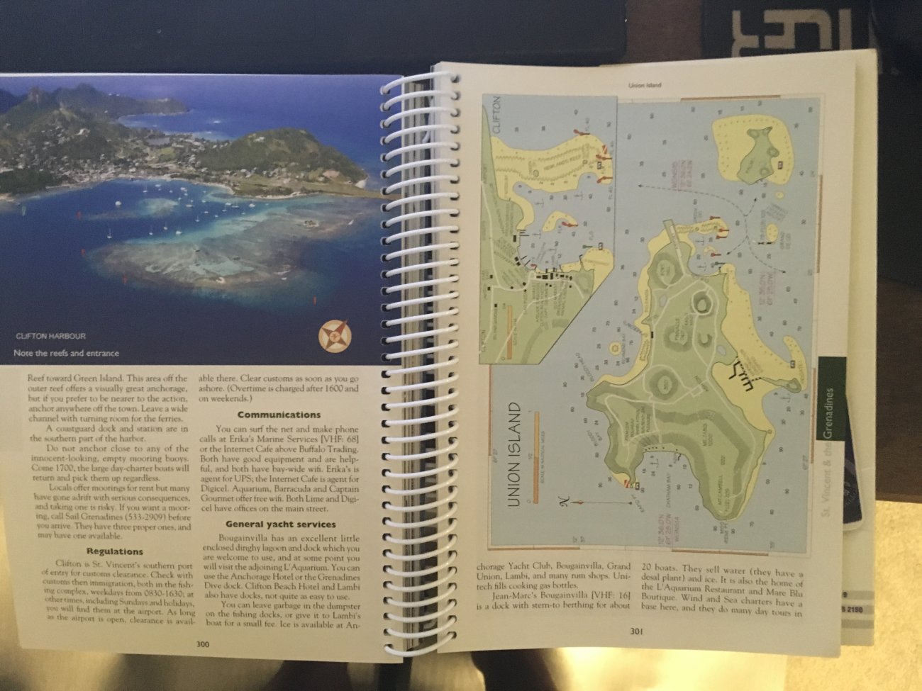
The Windward Islands Pilot shows high-level pics and lots of good info, but you have to remember this is 1-3 years old already, even the current version.

3DFD5CAE-B780-4B6F-819F-A58DC572BFDE.jpeg


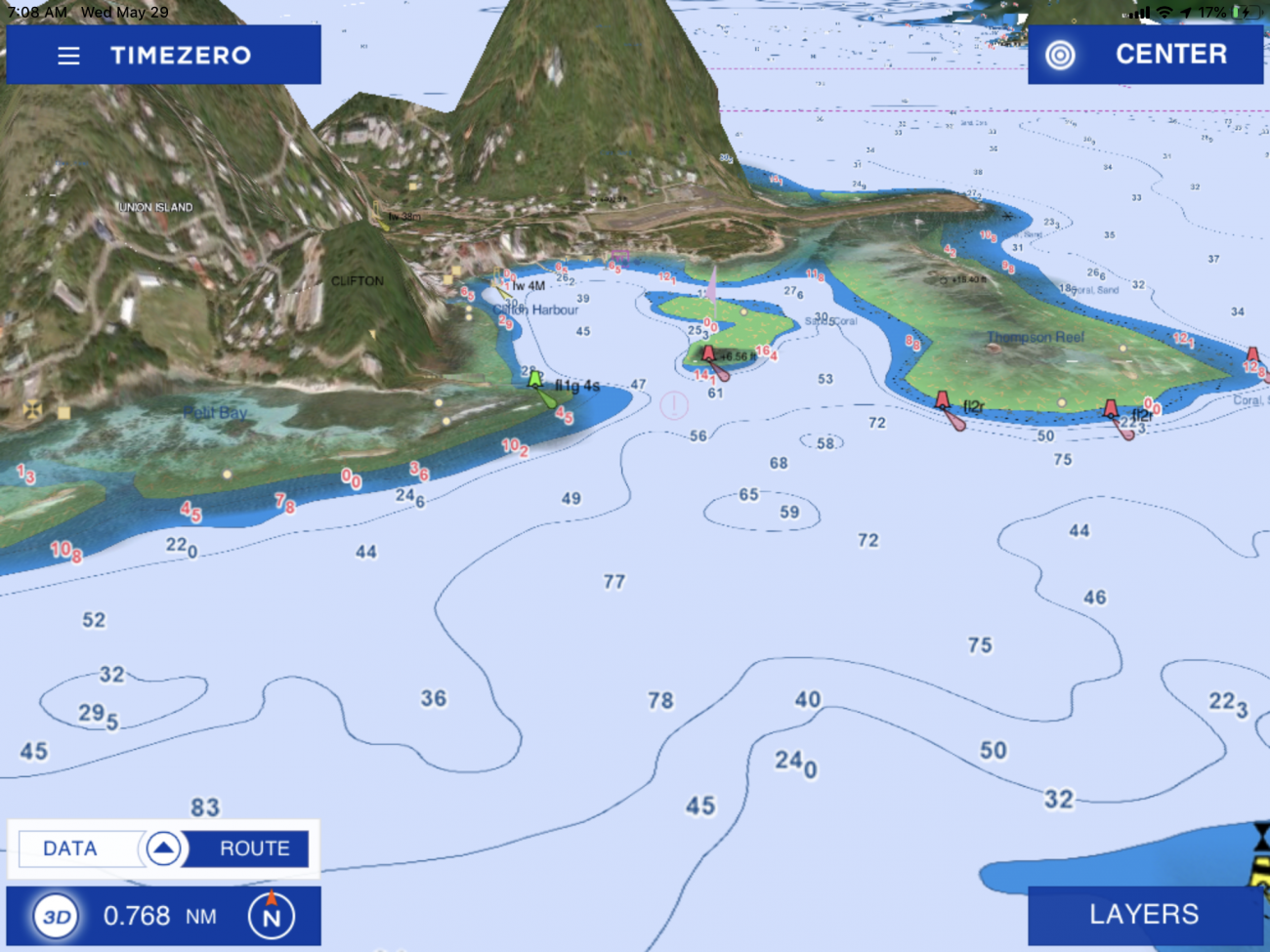
While not my fav, TimeZero is superb for SA, with land elevations and photo realistic views you can turn and tilt to get a water-level perspective.

98928FAE-6ADB-44A0-8D41-2C5847B61460.png


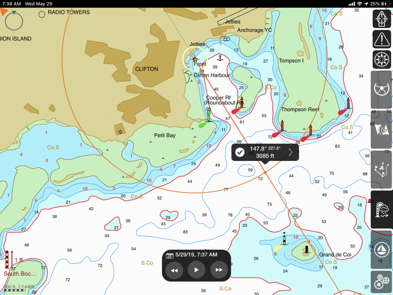
My go-to is iSailor, even though they pissed me off and changed the chart license policy. Anyway, they always have the best charting, and with overlayed tides and currents, makes a great way to know what to expect. Entering from the SW, expect to see what will seem like a straight line of starboard hand laterals in front of you before passing a west quadrant cardinal mark. It shows a couple of shallow mounts, but expect good water on the way. You can plan to turn when the light/day mark on the jetty hits 327 true on your bearing compass (adjust for dec!). Stay channel center passing between the two laterals at harbor entrance.

225B2375-FD88-49B1-81CA-4ECD71B8789D.png


Then you go. Landfall in daylight please. I could write forever, but others please jump in with tips, tricks, etc etc on how plan and execute.
 
Last edited:
Oct 19, 2017
7,744
O'Day 19 Littleton, NH
Nice subject, Jackdaw.

Nothing to add beyond the obvious, pay attention and look around you (360 deg. near and far).

-Will (Dragonfly)
 
  • Like
Likes: StargazerP303

JRT

.
Feb 14, 2017
2,046
Catalina 310 211 Lake Guntersville, AL
Following to learn. I have learned to watch the water color changes on our lake and if I see a bunch of fishing boats clustered in an area I know that is a shallow. No chart plotter on my C310, but I have a paper chart that I familiarize myself.
 
May 17, 2004
5,070
Beneteau Oceanis 37 Havre de Grace
I have learned to watch the water color changes on our lake and if I see a bunch of fishing boats clustered in an area I know that is a shallow
Yes, and in areas like inlets breaking waves can also be an indicator.
To all of the good tips already presented I'll add Go Slow. Trouble and confusion can come up quicker at 7 knots than at 3 or 4.
 

JRT

.
Feb 14, 2017
2,046
Catalina 310 211 Lake Guntersville, AL
Go slow is great one, my wife took the helm this weekend all the way into our slip for the first time with our C310 (she did it before with our O'day 25). She was slow and smooth, and with just a bit guidance did excellent. She took her time, followed the channel markers, avoided jet skis, fishing boats and power boat traffic like a champ. I sat back and helped guide, but her taking the helm and learning what to look for while under command of the boat was the best lesson to learn.
 

JRacer

.
Aug 9, 2011
1,333
Beneteau 310 Cheney KS (Wichita)
In flying, I learned never to taxi faster than a walk! Good advice for the taxiway and the harbor.
 

Mikem

.
Dec 20, 2009
820
Hunter 466 Bremerton
In the Pacific Northwest a terrific go to source is Waggoners cruising guide. It has entrance details of nearly every place a boat can go. Two other items to check are weather and especially around here tides and currents.

Winds, tides and currents can be your best friend or your worst enemy...know them.
 
Nov 8, 2010
11,386
Beneteau First 36.7 & 260 Minneapolis MN & Bayfield WI
In the Pacific Northwest a terrific go to source is Waggoners cruising guide. It has entrance details of nearly every place a boat can go. Two other items to check are weather and especially around here tides and currents.
yep, job#1 is figuring out what the best pilot guide is and getting it. Is Waggoners still available as a free download? Hope so, thats an amazing reference for free. I have it on my iPad. Most others cost US$30-60 in print form.
 
  • Like
Likes: jon hansen
Jul 12, 2011
1,165
Leopard 40 Jupiter, Florida
Like all things that may develop faster than you can think, visualize your plan, then make a good Plan B or bailout plan in case it all goes to $#!^. I know, "there's no such thing as a good Plan B, or else it would have been Plan A", but at least you can think through some alternatives to docking where you think you'll go.

I also call the harbor on radio, or preferably on the phone, to chat with the harbormaster / attendant about the planned approach, and ask any advice. Then I start making Plan B for backing out. All of these happened just last summer: What happens if the nice kid's not on the dock to catch your line like he said? What happens if the harbormaster on the radio did not understand that your sailboat really does have a six-foot draft, and you can't make it over into those shallow docks? What if there are weeds in the harbor, and your depth sounder shows three feet on approach? What if ...
 
Jul 27, 2011
5,002
Bavaria 38E Alamitos Bay
The last time entering new harbors for me as skipper was in 2017 during me 14-day charter in British Columbia. In addition to the plotter and paper chart, we consulted Waggoners frequently. I typically discuss the approach w/me first mate, and often post a lookout up fwd if there is shallow water about. My 7x50 Polaris (compass) Fujinon is handy if not actually around me neck! I also take notice of where the anchored boats are, their respective orientations, and whether they are riding to one anchor, or fixed by two. The situational awareness that JD mentioned. But the basic idea is, of course, to spot the channel markers and stay between them. (Make sure you know which buoy system you are following.) Entering Gorge Harbor at Cortes Island the first time I applied all of the above!! I’m sure the PNW guys here can attest as to why!!
 
Last edited:
  • Like
Likes: jon hansen

capta

.
Jun 4, 2009
4,772
Pearson 530 Admiralty Bay, Bequia SVG
For a new port, bay or harbor I use the local cruising guide. Charts are often out of date before you buy them wherever commercial traffic doesn't frequent. Most cruising guides have a website to check for updates if you have an older book. Generally, as I'm entering a new place I'm making my own marks on the GPS, so I can reenter anytime in any weather after the first time.
Entering my first coral Atoll in the SoPac (an uncharted interior) I saw a ship ahead and thought that where ever he can go I could too. Fortunately, I realized he was hard aground on a reef and had been for a number of years before I joined him on that reef, so now I NEVER, EVER follow another vessel.
But more than charts, cruising guides, and my chart plotter, my eyes are my number 1 go-to information source.
 

AaronD

.
Aug 10, 2014
723
Catalina 22 9874 Newberg, OR / Olympia, WA
yep, job#1 is figuring out what the best pilot guide is and getting it. Is Waggoners still available as a free download? Hope so, thats an amazing reference for free. I have it on my iPad. Most others cost US$30-60 in print form.
It's not free anymore, but you can buy it in sections for $5 each, which is very reasonable (since few of us will be cruising the full coverage area in any one year). PDFs at https://www.waggonerguidebooks.com/waggonerebooks.html or Kindle versions on Amazon. The spiral-bound print version is $30. Free was nice, but the prices are still very reasonable. No affiliation, just a satisfied customer. (Oh, and a plug for our own @jssailem, who's a reviewer for Waggoners).
 
  • Like
Likes: jssailem
Jan 19, 2010
12,369
Hobie 16 & Rhodes 22 Skeeter Charleston
Yes, and in areas like inlets breaking waves can also be an indicator.
There is a lot more to read than just breaking waves...I read this book with absolute rapture....


For example,...you can "see" shoals by the way the moon light (or a lamp light) streaks across the water and many other very cool tricks.
 
Jul 27, 2011
5,002
Bavaria 38E Alamitos Bay
... so now I NEVER, EVER follow another vessel.
Interesting. I’ve used that with much success. Particularly, taking the “short cut” through the reefs into the anchoring area of the Tobago Cays. Also, following locals through “cuts” in the dense kelp patch off Pt. Loma—a short cut into San Diego Bay when approaching from the north. Getting through Beazley Passage in the PNW, to name a few examples. Of course, I’m fairly close astern or I have just seen them get through.
 
Last edited:
Nov 8, 2010
11,386
Beneteau First 36.7 & 260 Minneapolis MN & Bayfield WI
There is a lot more to read than just breaking waves...I read this book with absolute rapture....


For example,...you can "see" shoals by the way the moon light (or a lamp light) streaks across the water and many other very cool tricks.
Huh. I just bought a copy. Any 400 page book on reading water HAS to have some nuggets!
 
  • Like
Likes: rgranger
Jul 1, 2010
962
Catalina 350 Lake Huron
Thanks for the link. Another book sold!

Besides all mentioned so far, we also like to check Active Captain for any info it might have for approaches, etc and compare that info to the local cruising guide. Sometimes it's very helpful, sometimes not so much.
 
Jan 11, 2014
11,398
Sabre 362 113 Fair Haven, NY
Well, expect Amazon to raise the price soon. Three books sold in the last half hour.